


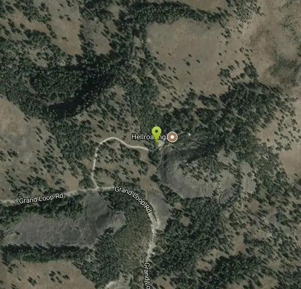
Hellroaring Creek Trail
Yellowstone National Park

| GPS: |
44°56'58.5"N 110°26'6.7"W Maps | Directions |
| State: | Wyoming |
National Park
Camp, Hike, and Swim
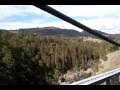
If the name didn't scare you enough, the Hellroaring creek trail begins with an arduous descent down to the the Yellowstone River Suspension Bridge.The suspension bridge is a beautiful sight, and is picturesque for photographers on the hike. This descent is matched with switchbacks, and continues for 1.1 miles through the Douglas-Fir forest. The Douglas-fir trees are indigenous to two types of terrain in the United States, mountainous regions where rocky variety of this tree can be found, and coastal areas where this variety thrives. The fir trees particular to the Hellroaring Trail detail the aftermath of the 1988 Yellowstone fires. The perscevereence these trees have can be seen in the new growth that continues to push through in the area. The trail follows along a sagebrush flat, that is met with the peak of Hellroaring Mountain . The Hellroaring Mountain is the largest slab of granite in Yellowstone.
The trail itself is mild and can be enjoyed by all ages. Along the creek by the trail is quite sandy, which creates a mini beach and a swimming area. There are many swimming holes around the hike that can be a lot of fun for hikers, and a great surprise for kids on the hike. If you loved the area and wish you could stay forever, there are several campsites in the Hellroaring Creek area. You might not be able to stay forever, but you can camp over night and take advantage of its beauty and swimming holes the next day.
Both of the Hellroaring Creek and Yellowstone River are colossal fishing areas, they have cutthroat, rainbow trout, brook,brown, and whitefish. In many areas of Yellowstone, there are fishing restrictions. You need to have a fishing permit that can be purchased at any of the ranger spots in the park. This is the Yellowstone fishers heaven. The Yellowstone River is home to the world's premier cutthroat and rainbow trout and the longest undammed river in the United States. With a variety of fish this large, and exquisite quality, it would be difficult not to go home with dinner! The sight offers plenty of fun for all, even if it sounds a little scary.
Check https://www.nps.gov/yell/planyourvisit/swimming-soaking.htm for closures, regulations, and conditions.
More Information
Be courteous, informed, and prepared. Read trailhead guidelines, stay on the trail, and don't feed the wildlife.
Read More- Plan Ahead and Prepare
- Travel & camp on durable surfaces
- Dispose of waste properly
- Leave what you find
- Minimize campfire impacts
- Respect wildlife
- Be considerate of other visitors
Directions
From Yellowstone National Park
- Head southeast on US-89 SToll roadEntering Wyoming(4.8 mi)
- Turn left onto Grand Loop RdToll road(14.4 mi)
- Turn left (0.2 mi)
From Tower in the Northeastern section of Yellowstone National Park, follow the Grand Loop road north for five miles to a sign for the Hellroaring Creek Trailhead. There is a parking area to your right down a short road. The trail descends one mile from the trailhead to a long suspension bridge over the Black Canyon of the Yellowstone. Once you cross the bridge, watch the Hellroaring Creek trail carefully. A number of intersecting trails meet it in the next mile. (Note, the trailhead is closer to Red Lodge, MT than Jackson, WY).


Other Swimming Holes and Hiking Trails Nearby

Lost Lake Trail
Tower Junction, Yellowstone National Park
2.6 miles SLost Lake Trail is a 2.8 mile hike that can be completed in less than two hours. This is an easy hike with very little elevation change. Hikers can enjoy forests, meadows and a view of Lost Lake...
Hike 8.2 mi
Garnet Hill Trail
Tower Junction, Yellowstone National Park
2.6 miles SEGarnet Hill Trail is a 7.6 mile loop that follows an old, dirt stagecoach road. This trail passes through large meadows, dusty areas with sagebrush, forests and beside the Yellowstone River. This...
Hike 7.3 mi
Agate Creek Trail
Tower Junction, Wyoming
2.8 miles SEAgate Creek Trail is a moderately difficult trail through some of Yellowstone's most beautiful and isolated landscapes. This 7.3 mile hike starts at the Yellowstone River Picnic Area. Parking is...
Hike 0.3 mi
Yellowstone River Picnic Area Trail
Tower Junction, Yellowstone National Park
2.8 miles SEThe Yellowstone River Picnic Area trail is 3.9 miles loop trail. It is called the Yellowstone Picnic Area trail because the beginning of the trail is in a picnic area.This hike features a...
Hike 16.9 mi
Specimen Ridge Trail (2K4)
Buffalo Ford, Wyoming
3.5 miles SESpecimen Ridge Trail is a challenging hike that requires navigational and technical skills to complete. This 17 mile hike is remote, and though it is marked by carins and blazes, it is often...
Hike
Tower Falls
Tower Junction, Yellowstone National Park
4.7 miles SETower Fall is a waterfall on Tower Creek in the northeastern region of Yellowstone National Park, in the U.S. state of Wyoming. Approximately 1,000 yards (910 m) upstream from the creek's...
Camp, Hike 4.0 mi
Specimen Ridge Day Hike and Fossil Forrest Trail
Buffalo Ford, Wyoming
5.9 miles SESpecimen Ridge Day Hike is a strenuous almost 4 mile trail to Specimen Ridge. This trail is rugged with a high elevation, and is not recommended for hikers with respiratory or heart...
Hike 8.5 mi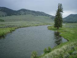
Slough Creek Trail
Tower Junction, Yellowstone National Park
6.2 miles ESlough Creek Trail is a 3.4 mile out and back trail that follows a historic wagon trail through several meadows. This trail is a fairly easy hike that has beautiful views of Slough Creek. The...
Hike
Forces of the Northern Range
Mammoth, Yellowstone National Park
6.5 miles WThis short 1/2 mile boardwalk located on the Blacktail Deer Plateau between Mammoth Village and Tower Junction will open your eyes and educate you about forces of nature that have sculpted the land...
Hike 7.4 mi
Blacktail Deer Creek to Yellowstone River Trail
Mammoth Hot Springs, Yellowstone National Park
7.8 miles WBlacktail Deer Creek Trail is a 7 mile out and back trail that leads to the Yellowstone River. Hikers on this trail will enjoy seeing green open fields, boulder formations and waterfalls at the...
Hike 0.8 mi
Wraith Falls Trail
Mammoth Hot Springs, Yellowstone National Park
9.2 miles WWraith Falls Trail is a less than 1 mile there and back hike that can be taken in under an hour. This is a wonderful family friendly hike that is easy for hikers of all levels. The hike leads...
Hike 4.4 mi
Chittenden Road - Mount Washburn Trail
Canyon Village, Yellowstone National Park
10.5 miles SHiking Mount Washburn via Chittenden Road is the shortest and easiest route to the top. The trail was once a service road and is now a clear well packed trail with a steady, gradual incline. The...
Hike 16.3 mi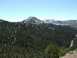
Mount Washburn Spur Trail
Canyon Village, Yellowstone National Park
10.5 miles SWashburn Spur Trail is an exciting 8-mile trail connecting the peak of Mount Washburn to Seven Mile Hole Trail near Canyon Village. Hikers typically hike the trail starting at Mount Washburn and...
Hike 3.4 mi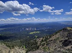
Dunraven Pass - Mount Washburn Trail
Canyon Village, Yellowstone National Park
11.4 miles SHikers looking for a scenic hike to the peak Mount Washburn will be pleased hiking the Mount Washburn Trail via Dunraven Pass. This trail winds through quiet forests to the peak. The trailhead for...
Hike 4.0 mi
Lava Creek Trail
Mammoth Hot Springs, Yellowstone National Park
12.7 miles WLava Creek Trail is a 4.2 mile hike where hikers can enjoy walking along the scenic Lava Creek. The trail passes Undine Falls and the Gardner River. Undine Falls is a beautiful 60 foot...
Hike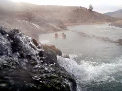
Boiling River
North Entrance, Yellowstone National Park
12.9 miles WThe Boiling River is created where a large hot spring enters the Gardner River, allowing the hot and cool waters to mix into a temperature comfortable enough to bathe in. The natural hot tub makes a...
Hot Springs, Swim
Mammoth/Gardiner Back Road
Mammoth Hot Springs, Yellowstone National Park
13.2 miles WThe only road open in Yellowstone National Park is Highway 89 at Gardiner, Montana to park Headquarters at Mammoth Hot Springs and from Mammoth Hot Springs to Silver Gate and Cooke City, Montana.
Hike, Mountain Bike 0.1-5.2 mi
Mammoth Hot Springs
Mammoth, Yellowstone National Park
13.2 miles WMammoth Hot Springs is a unique sight in Yellowstone National Park. The soft limestone in this area allowed the water to form colorful terraces. The extremely hot running water is clear and smooth,...
Camp, Hike 5.3 mi
Beaver Ponds Trail
Mammoth, Yellowstone National Park
13.2 miles WBeaver Ponds Trail is a wonderful short hike accessible from Mammoth Hot Springs. The trail forms a loop between the two trailheads available at Mammoth Hot Springs. The loop is just over 5 miles...
Hike 8.1 mi
Sepulcher Mountain Trail
Mammoth Hot Springs, Yellowstone National Park
13.3 miles WSepulcher Mountain Trail is an 11 mile loop trail from Mammoth Hot Springs to the peak of Sepulcher Mountain. This is a challenging hike with a 3,500 foot ascent to the 9,652 foot peak. The...
HikeNearby Campsites
Tower Falls
Tower Junction, Yellowstone National Park
4.7 miles SETower Fall is a waterfall on Tower Creek in the northeastern region of Yellowstone National Park, in the U.S. state of Wyoming. Approximately 1,000 yards (910 m) upstream from the creek's...
Camp, Hike
Slough Creek Campground
Tower Junction, Yellowstone National Park
6.3 miles ESlough Creek campground is a small but very popular campground on the Northeast Entrance Road. Most of the campsites are situated right on the banks of Slough Creek where fishing is a favorite...
Camp
Mammoth Hot Springs Campground
Mammoth Hot Springs, Yellowstone National Park
12.8 miles WMammoth Hot Springs Campground is the only campground in Yellowstone that is open to campers year-round. Campsites cannot be reserved and are available on a first come first served basis. It is...
Camp 0.1-5.2 mi
Mammoth Hot Springs
Mammoth, Yellowstone National Park
13.2 miles WMammoth Hot Springs is a unique sight in Yellowstone National Park. The soft limestone in this area allowed the water to form colorful terraces. The extremely hot running water is clear and smooth,...
Camp, Hike
Canyon Campground
Canyon Junction, Yellowstone National Park
15.0 miles SCanyon Campground is a popular choice for visitors to Yellowstone National Park, and it's easy to see why. Located in the heart of the park, the campground offers easy access to some of the...
Camp
Indian Creek Campground Yellowstone
Mammoth Hot Springs, Yellowstone National Park
15.4 miles WIndian Creek Campground is a quiet and secluded wooded campground within Yellowstone National Park, ideal for tent campers. It’s close to lots of hiking and fishing, and only a few miles to...
Camp
Pebble Creek Campground
Northeast Entrance, Yellowstone National Park
15.9 miles EPebble Creek is a popular campground for fishermen and those seeking a more quiet and smaller campground in Yellowstone National Park. The campsites can fill very early, so get there before 11 AM...
Camp 1.5-3.8 mi
Little Gibbon Falls
Norris, Yellowstone National Park
18.9 miles SWIce Lake and Little Gibbon Falls Loop is a 4.5 mile loop trail located near Yellowstone National Park, Wyoming. The trail is good for all skill levels and primarily used for hiking, but there are...
Camp, Canoe, Hike
Norris Campground
Norris, Yellowstone National Park
19.5 miles SWNorris campground is centrally located in Yellowstone National Park and offers a good spot for those planning to visit many of the most famous features in Yellowstone. Norris is a relatively short...
Camp
Fishing Bridge RV Campground
Lake Village, Yellowstone National Park
26.9 miles SThe Fishing Bridge Recreational Vehicle Park is located near the mouth of the Yellowstone River as it leaves Yellowstone Lake. The RV park is named after the Fishing Bridge, a wooden vehicle bridge...
Camp
Bridge Bay
Lake Village, Yellowstone National Park
28.7 miles SBridge Bay Campground was named for its proximity to Bridge Bay Marina on Yellowstone Lake. The area is quite scenic, with wooded areas, open meadows and some limited views of the lake. Because of...
Camp
Madison Campground
Madison, Yellowstone National Park
29.9 miles SWMadison Campground is named for its proximity to the Madison River, which runs through the area in a lush mountain setting rich in wildlife. Madison Campground is at an elevation of 6,800’ and...
Camp
Grant Village
Grant Village, Yellowstone National Park
38.9 miles SGrant Village was built in 1984 and named after Ulysses S. Grant, president when Yellowstone became the world’s first national park in 1872. Located near the West Thumb of Yellowstone Lake,...
Camp, Canoe, Kayak 14.8 mi
Biscuit Basin to Fairy Falls and Firehole Meadows
Old Faithful, Yellowstone National Park
40.3 miles SWFreight Road trail is a almost 15 mile hike that leaves from Biscuit Basin or Fountain Flats Drive. This hike is a beautiful remote hike that passes several unique landmarks, breaking up this hike...
Backpack, Camp, Hike 25.6 mi
East Rosebud Lake
Roscoe, Montana
42.5 miles NEA scenic backpacking trip through some of the most beautiful areas in the Beartooth Mountains of Montana, East Rosebud trail takes hikers into some of the more secluded parts of Montana.
Backpack, Camp, Canoe, Hike 6.9 mi
Heart Lake Trail
Grant Village, Yellowstone National Park
44.4 miles SThe trail is very clear and leads to a moderate eight mile hike to Heart Lake. This hike has many possibilities. Day hikers need to push their time to make sure they are on the trail early to allow...
Backpack, Camp, Hike, Hot Springs 0.1 mi
Lewis Lake Campground
Grant Village, Yellowstone National Park
47.1 miles SLewis Lake is located in the southern part of Yellowstone National Park. It is 4 miles southeast of Shoshone Lake. Lewis Lake offers a plethora great water activities. This lake offers...
Camp, Canoe, Kayak


