


52 Hiking Trails near Big Elk Creek
first prev 1 2 3 next lastShowing Hiking Trails within 50 miles Distance miles of Forest Rd 270, Irwin, ID 83428, USA City, Zip, or Address

Table Rock / Table Mountain
Driggs, Idaho
31.6 miles NAt 11,300 feet, Table Mountain is possibly the most beautiful climb this side of the Tetons and offers what may well be the very best view of the Grand Tetons. It's just far enough away...
Camp, Hike
Poison Flats
Ririe, Idaho
32.2 miles NWHike near Ririe, Idaho
Hike 0.6-2.2 mi
Fish Creek Area
Ririe, Idaho
32.4 miles NWFish Creek is a network of mountain bike trails up in the Big Hole Mountains. The trails are easily accessed from either the Ririe or Rexburg side of the range. The trail system is set up much...
Hike, Mountain Bike 1.1 mi
Hidden Vista / Pine Loop
Ririe, Idaho
32.7 miles NWYou'll find the Hidden Vista trailhead on the South End of the Buckskin Morgan parking lot about a mile past Y Junction. This is a short trail with a little up and a little down for just under a...
Hike, Mountain Bike 1.7 mi
Buckskin Morgan Ridge
Ririe, Idaho
32.7 miles NWGoing up is a little tough because of the rocks, but once you clear the top it is a twisty down hill portion [until] you get to a fenced road. From there you can turn around or keep going strait...
Hike, Mountain Bike 4.9 mi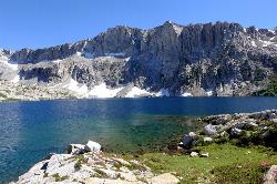
Amphitheater Lake
Alta, Wyoming
32.7 miles NEBackpack and Hike near Alta, Wyoming
Backpack, Hike 3.8 mi
Kelly Mountain Trail
Ririe, Idaho
32.9 miles NWKelly Canyon Trail is a moderate, uphill trail that can be used by hikers, mountain bikers, and ATV riders. The trail features views of hills, mountains, trees, wildflowers, and some wildlife. Dogs...
Cross-country Ski, Hike, Mountain Bike, Snowshoe 0.6 mi

Packsaddle Lake
Tetonia, Idaho
33.1 miles NPacksaddle is one of the less well known lakes/trails in the area. If you've got a good offroad vehicle, you can probably make it all the way to the end of the road, otherwise, it's just an...
Dive, Hike, Mountain Bike, Snowshoe, Swim 3.8 mi
Stinking Springs
Ririe, Idaho
33.2 miles NWStinking Springs is a great early to late season trail. Being at the edge of the Big Hole range, it gets spring earlier and winter later than other trails in the range. It's closed from December...
Hike, Mountain Bike 3.9-14.4 mi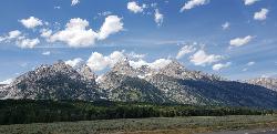
Grand Teton
Jackson Hole, Wyoming
34.1 miles NEAt 13,770 feet above sea level, the Grand Teton towers majestic over Southeastern Idaho and Western Wyoming, making it a life goal of many amateur climbers and outdoor enthusiasts. The...
Backpack, Hike, Rock Climb 13.8 mi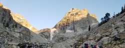
Middle Teton
Jackson Hole, Wyoming
34.1 miles NEAt 12,804 ft above sea level, the Middle Teton is a challenging and beautiful hike from the trailhead all the way to the peak. The first part of the trail is dirt trails through the trees. That...
Backpack, Hike, Rock Climb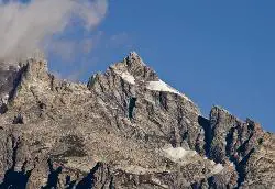
Mount Owen
Jackson, Wyoming
34.1 miles NEHike near Jackson, Wyoming
Hike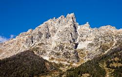
Teewinot Mountain
Jackson Hole, Wyoming
34.1 miles NEBackpack and Hike near Jackson Hole, Wyoming
Backpack, Hike
Blue Miner Lake
Jackson, Wyoming
34.2 miles NEBackpack and Hike near Jackson, Wyoming
Backpack, Hike 0.5-3.5 mi
Webster's Dam
Ririe, Idaho
35.4 miles NWAlso known as Manmade Falls or the Woodmansee Dam, Webster Dam is an abandoned dam located deep in Moody Creek canyon, the dam was abandoned when sediment built up behind the dam which then...
Camp, Hike, Mountain Bike 24.3 mi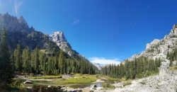
Cascade Canyon Trail
Jackson Hole, Wyoming
35.6 miles NEThis hike starts the same as the Jenny Lake trail, then after you pass the boat dock, it takes off up Cascade Canyon just to the north of Teewinot, Mount Owen, and the Grand Teton along Cascade...
Backpack, Hike 0.3-5.1 mi
Jenny Lake Trail
Jackson Hole, Wyoming
35.6 miles NEOne of the most popular trails to visit in Grand Teton is the Jenny Lake Trail. The Jenny Lake Trail, located near Moose, Wyoming, is an easy trail that loops around the lake. Along with the sheer...
Hike 3.6 mi
String Lake
Alta, Wyoming
37.3 miles NEString Lake is a shallow lake that connects Leigh Lake and Jenny Lake at the base of Mount St. John and Rockchuck Peak. From the lakeshore, you can also take in beautiful views of Teewinot and Mt....
Canoe, Hike, Kayak, Swim
Badger Creek
Tetonia, Idaho
37.3 miles NBadger Creek is a stream located just 13.6 miles from Ashton, in Teton County, in the state of Idaho, United States, near France, ID. Whether you’re spinning, baitcasting or fly fishing your...
Camp, Cross-country Ski, Hike, Mountain Bike, Rock Climb 10.5-16.2 mi
Paintbrush Canyon
Alta, Wyoming
37.4 miles NEBeautiful trail along String Lake, Leigh Lake, and Lake Solitude. For even more solitude, scramble up the rocks to Micah Lake for a beautiful view and even fewer people. You won't find...
Backpack, Hike


