


137 Hiking Trails near Quartz Ridge Trail
first prev 1 2 3 4 5 6 7 next lastShowing Hiking Trails within 50 miles Distance miles of 8A, Phoenix, AZ 85018, USA City, Zip, or Address

Crismon Wash Trail
Mesa, Arizona
23.6 miles EThe Crismon Wash Trail is 1.8 mile trail that is accessible from the south at the Crismon road trailhead. It is also accessible from the Blevins train to the north. There are several...
Hike, Horseback, Mountain Bike 3.6 mi
Toothaker Trail
Goodyear, Arizona
23.6 miles SWToothaker is an easy roller coaster of a trail. It crosses numerous washes ranging from small to large and can be a tad loose and/or rocky in some sections. The end reward is a nice view of Rainbow...
Hike, Horseback, Mountain Bike
Dysart Trail
Goodyear, Arizona
23.6 miles SW$6 entry fee per car.
Hike, Horseback, Mountain Bike
Rainbow Valley to Toothaker Loop Trail
Goodyear, Arizona
23.6 miles SWEstrella Mountain Regional Park has many trails within it, a great beginner to intermediate friendly trail is the Rainbow Valley to Toothaker Loop Trail. This 6.6 mile hike is mostly flat with a few...
Hike, Horseback, Mountain Bike 1.0 mi
Quail Trail
Goodyear, Arizona
23.7 miles SWQuail Trail is the access trail from the Nature Center to the main trail system. It is a pretty steep climb, but smooth and steady. Quail Trail is a spur trail in the Estrella Mountain...
Hike, Horseback, Mountain Bike
Quartz Peak Trail
26.5 miles SW
Hike near
Hike
Wildlife Trail
Waddell, Arizona
28.3 miles WA short trail which terminates at a small pond.
Hike, Horseback
Mule Deer Trail (Maricopa Trail)
Waddell, Arizona
28.3 miles WMule Deer trail is a 3.5 mile out-and-back trail that it part of the Maricopa Trail within White Tank Mountain Regional Park. This is a beginner to moderate friendly trail for both hikers and...
Hike, Horseback, Mountain Bike
South, Bajada, Mule Deer Loop Trail
Waddell, Arizona
28.3 miles WSouth - Bajada - Mule Deer Loop is a 4.1 mile loop trail located near Waddell, Arizona that offers the chance to see wildlife. The trail is rated as moderate and is accessible from...
Hike, Horseback, Mountain Bike
Black Rock Loop Trail
Waddell, Arizona
28.4 miles WBlack Rock Trail is a 1.3 mile loop trail located near Waddell, Arizona and is good for all skill levels. The trail is primarily used for hiking and is accessible year round. Black...
Hike
Goat Camp Trail
Buckeye, Arizona
28.5 miles WGoat Camp Trail is a well-liked mountain biking and hiking trail in White Tank Mountain Regional Park. This is a 16 mile out-and-back trail that is rated as advanced due to the length, as well as the...
Hike, Mountain Bike 4.8 mi
Lost Creek Petroglyph Trail
Buckeye, Arizona
29.9 miles WStarting at Verrado's trailhead, the trail heads a short ways to a petroglyph site. While a little rocky at times, the trail is easy. To deter vandals, a very necessary fence with barbed-wire has...
Hike, Mountain Bike
Siphon Draw Trailhead to Flatiron
Apache Junction, Arizona
31.1 miles EThe Siphon Draw Trail up to Flatiron is a beautiful trail within the Lost Dutchman State Park. It is a 5.5 mile, there and back trail near Apache Junction, Arizona. It is a more advanced hike with...
Hike 3.9 mi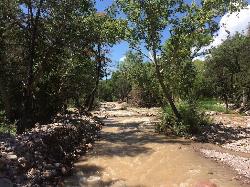
Cave Creek Swimming Hole
Cave Creek, Arizona
31.5 miles NHidden along Cave Creek Trail #4 is a swimming hole deep enough to refresh from the summer heat. It takes almost four miles of hiking in Arizona desert to reach the swimming hole, but the water is...
Hike, Swim 1.4 mi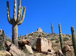
Ballantine Trail
Rio Verde, Arizona
33.8 miles NEthis trail looks a lot better once it moves away from the highway. A somewhat strenuous climb reveals a landscape of knuckle-and-joint, mica-imbedded boulders, deep gorges and a battalion of regal...
Hike 5.4 mi
Denton Trail #69
Tonto Basin, Arizona
43.6 miles NEFrom FR 421, the trail climbs steadily up the east face of the mountain. Some sections are quite steep. The trail eventually tops out at 5,760 feet elevation and then descends to Big Pine Flat for...
Hike, Mountain Bike

Brittlebush Trail
Phoenix, Arizona
46.6 miles SWBrittlebush trail is a flat, 12-mile round trip, out-and-back trail in the heart of the Maricopa Wilderness. It's best used from November - April, and should be avoided in the Summer months...
Hike, Mountain Bike


