


249 Things to do near Badger Creek
first prev 2 3 4 5 6 7 8 9 10 11 next lastShowing results within 50 miles Distance miles of 2480 W 10000 N, Tetonia, ID 83452, USA City, Zip, or Address

Webster's Dam
Ririe, Idaho
25.2 miles SWAlso known as Manmade Falls or the Woodmansee Dam, Webster Dam is an abandoned dam located deep in Moody Creek canyon, the dam was abandoned when sediment built up behind the dam which then...
Camp, Hike, Mountain Bike
The Arcane
Ririe, Idaho
25.4 miles SWRock Climb near Ririe, Idaho
Rock Climb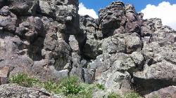
Basalt Bluff / Steve's Rock
Teton, Idaho
25.4 miles WDon't go anywhere marked No Trespassing and Beware of the Attack Bees at the top of the cliffs and the Stinging Nettle at the bottom. About a mile north of Loon Lake/Wentworth Springs Road...
Rock Climb 4.6 mi
Coal Creek Trail
Alta, Wyoming
25.6 miles SEnjoy outstanding views from upper Coal Creek Meadows, this hike description travels just beyond the meadows to the top of Coal-Mesquite Divide where you'll enjoy some rather dramatic views of...
Hike, Mountain Bike

Wolverine Creek Trail
Ririe, Idaho
25.9 miles SWThe Wolverine Creek Trail is a doubletrack trail in Ririe, Idaho. It begins at South Fork Road and ends at Wolverine trailhead. It is commonly used by dirt bikes and four wheelers. This trail is...
Mountain Bike
Marshall's
Saint Anthony, Idaho
26.0 miles WMarshall's Wave is located on the North Fork of the Teton River, where the Teton River splits into the north and south forks. The wave is created by a headgate and is best at flows above 600...
Kayak
Kelly Canyon Loops
Ririe, Idaho
26.1 miles SWThis mountain bike trail near Kelly Canyon Ski Area has several options available. Highlights are the views in all directions from the top of the mountain. Trails: Waterfall...
Mountain Bike
Ashton Hill
Ashton, Idaho
26.2 miles NWFairly thick forest. Considerable underbrush. Lots of places in the area to play.
Airsoft, Paintball
Bighole Mountains / Moody
Ririe, Idaho
26.2 miles SWThis is a little unofficial campground with a plenty of shade for your basecamp and a wooded field with great boundaries. There's 2 roads that split and merge giving you very simple...
Airsoft, Paintball
Big Hole Dispersed Campsites
Ririe, Idaho
26.3 miles SWA dispersed campsite is simply an unestablished and unmaintained area where people camp. Often, this means that there is a campfire or other basic campsite feature to identify the site and that's...
Camp 11.9 mi
Waterfall Loop
Ririe, Idaho
26.4 miles SWTrail is a mixture of single track, forest road and double track. Provides a variety of scenery. About 1400 feet of elevation change throughout the trail.GPS is a must unless you are going with...
Mountain Bike
Sheep Falls on Henry's Fork
Island Park, Idaho
26.5 miles NWSheep Falls cascades approximately 25' through a narrow basalt chute on the North Fork of the Snake River near Island Park, Idaho. Compared to nearby Lower and Upper Mesa Falls, that height may...
Hike
South Fork Snake River Trail
Ririe, Idaho
26.7 miles SWGo left at the trail head. It heads down about a mile and a half on double track. Then you'll come to a creek crossing. After the crossing the trail heads across a gate. Head left...
Mountain Bike 5.7-8.1 mi
Space Cruz
Ririe, Idaho
26.9 miles SWThe trail starts out with a really flowy singletrack then connects up to some ATV trails. On the single track, just stay on the main trail. There are several little splits several you can take...
Cross-country Ski, Mountain Bike 1.1 mi
Hidden Vista / Pine Loop
Ririe, Idaho
26.9 miles SWYou'll find the Hidden Vista trailhead on the South End of the Buckskin Morgan parking lot about a mile past Y Junction. This is a short trail with a little up and a little down for just under a...
Hike, Mountain Bike 1.7 mi
Buckskin Morgan Ridge
Ririe, Idaho
26.9 miles SWGoing up is a little tough because of the rocks, but once you clear the top it is a twisty down hill portion [until] you get to a fenced road. From there you can turn around or keep going strait...
Hike, Mountain Bike
Lower Hawley Gulch Trail
Ririe, Idaho
27.2 miles SWThis is a singletrack biking trail in Ririe, Idaho. The trail is mainly flat with a few gradual slopes. You may have to carry your bike over obstacles such as fallen trees, logs, and small ponds....
Mountain Bike
Sucky Courtney's
Saint Anthony, Idaho
27.2 miles WKayaker playing in Marshall's Wave near Rexburg, Idaho. The wave is located on the North Fork of the Teton River and is best at flows above 600 cfs. The wave is good for beginners. It has a...
Kayak
Table Rock Campground
Ririe, Idaho
27.2 miles SWTable Rock / Poison Flat Campground is located at the Caribou-Targhee National Forest which occupies over 3 million acres and stretches across southeastern Idaho, from the Montana, Utah, and Wyoming...
Camp 4.3 mi
Leaning Fir #169
Ririe, Idaho
27.2 miles SWMountain Bike near Ririe, Idaho
Mountain Bike


