


180 Things to do near Civil Defense Caves
first prev 1 2 3 4 5 6 7 8 9 next lastShowing results within 50 miles Distance miles of Unnamed Road, St Anthony, ID 83445, USA City, Zip, or Address
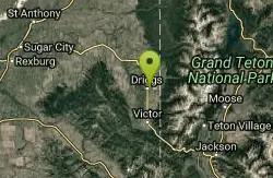
Teton Valley Disc Golf Course
Driggs, Idaho
45.0 miles SEEnjoy 360-degree mtn views from this city park that also features a skateboard area. This course is on your way to the Grand Targhee course. Public (No Fee)
Disc Golf 0.1-0.2 mi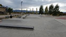
Driggs Bike and Skate Park
Driggs, Idaho
45.2 miles SEThis is a great concrete skatepark and small mountain bike park with great features, both natural and wooden. There's a great pavilion right next to the skatepark and parking lot. While...
Mountain Bike, Skateboard
Henderson Canyon
Victor, Idaho
45.4 miles SETrail begins as dirt road/double track with numerous "cow" trails breaking off of road. Some of these trails see more tire tracks than others.
Mountain Bike 1.9 mi

Terraced Falls
Grant Village, Yellowstone National Park
46.1 miles E3.6 mile easy out and back trail. 430 ft Elevation gain. The trailhead is off Ashton-Flagg Ranch Road along Yellowstone's South border. Ashton-Flagg Ranch Road is closed during the winter.
Hike
Alta Nordic Trail
Alta, Wyoming
46.1 miles SEDistance: 6.2 miles (10km) Trail Map: Alta_Nordic_Trail_2015.pdf Grooming Report: http://tvtap.org/nordic-grooming
Cross-country Ski, Snowshoe
Wade Lake
Cameron, Montana
46.3 miles NCamp, Canoe, Kayak, and Swim near Cameron, Montana
Camp, Canoe, Kayak, Swim
Freeman Park
Idaho Falls, Idaho
46.5 miles SA couple of creek crossings add to appeal. Snake river borders most of this beautifully maintained course. Good elevation and variety. Public (No Fee)
Disc Golf
Grand Targhee Resort
Moose, Wyoming
47.2 miles SESpectacular Teton mountain course at 8000' elevation. Discs in Activity Center. Head bartender in resort's Trap Bar is the course pro. Course open when snow is gone; usually June to...
Disc Golf
Cold Springs
Moose, Wyoming
47.3 miles SETrail is easiet down as a loop but can be done as a shuttle as well. Take a right into Teton Canyon and park at the first big parking lot on the left. About 50 yards from Ski Hill rd....
Mountain Bike
Webber Creek
Dubois, Idaho
47.3 miles W7000-foot elevation. A dispersed area with a trailhead, the only amenity is a toilet. Picnicking. The Webber Creek Trail departs from here, and heads west toward Scott Peak. Fishing in the creek....
Backpack, Camp, Hike, Horseback, Hot Springs, Mountain Bike
South Fork Snake River Trail
Ririe, Idaho
47.3 miles SGo left at the trail head. It heads down about a mile and a half on double track. Then you'll come to a creek crossing. After the crossing the trail heads across a gate. Head left...
Mountain Bike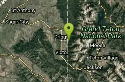
Spring Creek Trail
Alta, Wyoming
47.4 miles SEThis trail starts at the remains of the historic Rapid Creek Ranger Station. The trail heads east following an old road. After crossing Rapid Creek, the trail climbs up to a ridge...
Mountain Bike 1.0-7.5 mi
Idaho Falls Greenbelt
Idaho Falls, Idaho
47.5 miles SThe Idaho Falls Greenbelt is one of Idaho Falls charms located in the heart of Idaho Falls, next to the historic Idaho Falls downtown. The paved foot-trail is approximately 6 miles around,...
Hike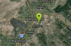
Eagle Point Park
Ammon, Idaho
47.5 miles SPractice course with 3 baskets and 3 tees. Play each basket from each tee for 9 holes. Playground nearby. Private (No Fee)
Disc Golf 14.8 mi
Biscuit Basin to Fairy Falls and Firehole Meadows
Old Faithful, Yellowstone National Park
47.6 miles NEFreight Road trail is a almost 15 mile hike that leaves from Biscuit Basin or Fountain Flats Drive. This hike is a beautiful remote hike that passes several unique landmarks, breaking up this hike...
Backpack, Camp, Hike 4.5 mi
Aspen Trail
Alta, Wyoming
47.7 miles SEAspen Trail (tr 034) is single track trail for 4.35 miles along 6,800 ft contour to Darby Canyon (tr 012). Spring Creek Trail (tr 032) is double track trail for 3.68 miles to end. The trail starts...
Hike, Mountain Bike
West Pine Creek Trail
Ririe, Idaho
47.7 miles SENon-motorized use. source: fs.usda.gov
Mountain Bike
Grove Creek to Drake Creek
Victor, Idaho
47.7 miles SEGreat loop trail that connects several trails through the area. This trail was recently rerouted, and so will have plenty of new switchbacks to take as riders climb the mountain. Originally this...
Mountain Bike
Rocky Peak Via Spooky Trail
Victor, Idaho
47.7 miles SEYou will start up Spooky trail which is the only trail in the parking area. There is a trail junction on your left about 1.2-1.5 just keep going straight. At about 2.6 from TH you'll...
Mountain Bike
Trail Canyon Trail
Ririe, Idaho
47.7 miles SEThe Trail Canyon trail begins at Trail Canyon Parklot, T8s R43e Sec28 and ends at Intersect Trail 5251,t8s R43e Sec28. source: fs.usda.gov
Mountain Bike


