


202 Things to do near Coal Creek Trail
first prev 2 3 4 5 6 7 8 9 10 11 next lastShowing results within 50 miles Distance miles of Coal Creek Trail Head, Alta, WY 83414, USA City, Zip, or Address

Stinking Springs
Ririe, Idaho
33.8 miles WStinking Springs is a great early to late season trail. Being at the edge of the Big Hole range, it gets spring earlier and winter later than other trails in the range. It's closed from December...
Hike, Mountain Bike
Paramount Wall / Blanche Rock
Ririe, Idaho
34.5 miles WSitting high above the road, the routes at Paramount offer great exposure and relief from the afternoon summer sun. Chuck Oddette, Steve Reiser and Jed Miller established the routes from 1989...
Camp, Horseback, Rock Climb
Kelly Island Campground
Ririe, Idaho
34.7 miles WThis is a BLM campground with 14 campsites for RVs or tents and 1 group campsite. Daily Rates $5-20 Showers No Bathrooms Vault...
Camp 1.6 mi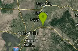
Skyline
Ririe, Idaho
34.8 miles WPunchy climb out of Little Kelly Canyon. Great vistas along a narrow traverse. Fast and loose downhill. A mix of narrow singletrack and old motorized trail.
Mountain Bike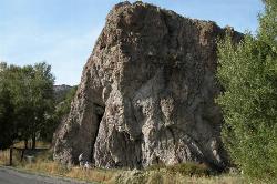
Heise Rock (AKA Elephant Rock)
Ririe, Idaho
35.5 miles WCLOSED. Rock climbing is no longer permitted. This volcanic plug sits just off the road near the Heise Hot Springs Golf Course. It is also referred to as Elephant Rock or Chuck's Choss Pile. Aid...
Rock Climb
Herbert Idaho Ghost Town
Ririe, Idaho
36.3 miles WCLOSED. Private property marked NO TRESPASSING. Herbert is a small ghost town that was operated until the 40s, but with the invention of the automobile, it was much more convenient to live in Rexburg...
Hike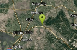
Big Feeder
Ririe, Idaho
36.3 miles WKayak near Ririe, Idaho
Kayak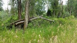
On the banks by Heise
Ririe, Idaho
36.9 miles WOn the banks of the river near Heise. Plenty of trees and ground cover.
Airsoft, Paintball 0.3-0.6 mi
Cress Creek Nature Trail
Rexburg, Idaho
38.0 miles WMeandering along the scenic South Fork of the Snake River, the beautiful 1¼ mile Cress Creek Nature Trail will lead you on a journey through sagebrush-grass communities, over juniper covered...
Hike
Blacktail Day Use Area
Ririe, Idaho
38.0 miles WOn the North end of Ririe Reservoir there is a great little park with cliff jumping and even rock climbing. There is a trail from the south end of the parking lot down along the cliffs. There are...
Dive, Rock Climb, Swim
Blacktail Lake / Ririe Reservoir
Idaho Falls, Idaho
38.9 miles WCanoe and Swim near Idaho Falls, Idaho
Canoe, Swim
Sheep Falls on Fall River
Ashton, Idaho
39.7 miles NThe lesser known Sheep Falls on Fall River is a local treasure off of Cave Falls road. There are primitive campsites and beautiful views for a great picnic spot. The water splits and comes down in...
Camp 0.8 mi
Conant Creek Pegram Truss Railroad Bridge
Ashton, Idaho
40.4 miles NWAs part of the Rails to Trails project, this old railroad bridge has been transformed into a very safe little viewing experience for the whole family. You can drive right up to the bridge where there...
Hike
Twin Bridges Park
Rexburg, Idaho
40.5 miles WTwin Bridges is a campground 12 miles South East of Rexburg on S. 600 E. It is maintained by Madison County Parks Department. It is a 27 acre park of pristine land rich with wildlife on the Snake...
Camp, Canoe
Falls River, Lower Run
Ashton, Idaho
40.6 miles NFall River rises on the Madison and Pitchstone plateaus in the southwest corner of Yellowstone National Park, Wyoming and flows approximately 64 miles (103 km) to its confluence with the Henrys Fork...
Whitewater
Ririe River Island (AKA Twin Bridges)
Rexburg, Idaho
40.6 miles WGo into the campground WHERE PAINTBALLING IS NOT ALLOWED. Park there and cross the creek on the North side of the park. You'll have to cross the river using the rocks that are there so not too...
Airsoft, Paintball
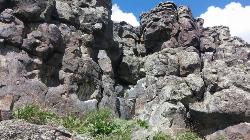
Basalt Bluff / Steve's Rock
Teton, Idaho
40.8 miles NWDon't go anywhere marked No Trespassing and Beware of the Attack Bees at the top of the cliffs and the Stinging Nettle at the bottom. About a mile north of Loon Lake/Wentworth Springs Road...
Rock Climb
Porcupine Creek
Ashton, Idaho
41.5 miles NPorcupine Creek is a hunting, fishing, camping, and swimming spot near Ashton, Idaho in Fremont County within Targhee National Forest. It's surrounded by forests, meadows, and a creek...
Camp, Swim
Loon Lake
Ashton, Idaho
41.7 miles NCamp, Kayak, and Swim near Ashton, Idaho
Camp, Kayak, Swim 1.1 mi
Fish Lake
Ashton, Idaho
42.4 miles NHike near Ashton, Idaho
Hike


