


233 Things to do near Mesa Falls
first prev 3 4 5 6 7 8 9 10 11 12 next lastShowing results within 50 miles Distance miles of Forest Rd 20295, Ashton, ID 83420, USA City, Zip, or Address

Purple Mountain Trail
Madison, Yellowstone National Park
39.3 miles NEPurple Mountain Trail is a 6 mile out and back trail to the peak of purple mountain. This is a beautifully forested trail with little foot traffic is a quiet respite from the crowds of...
Hike 2.1 mi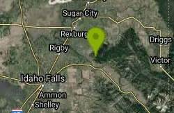
Batman
Ririe, Idaho
39.7 miles SThis trail features rolling terrain, and multiple short, steep downhill sections followed by short steep uphill sections. This trail follows the fence line. Watch out for cows (and cow droppings)...
Mountain Bike 1.7 mi
Randy's Cow Trail / Ken's Corner
Ririe, Idaho
39.8 miles SThis trail descends from the fence corner at the West end of Batman and continues down to Lyon's Creek Parking just off Lyon's road. The top of this trail is only a couple hundred yards from...
Mountain Bike 5.7-8.1 mi
Space Cruz
Ririe, Idaho
39.9 miles SThe trail starts out with a really flowy singletrack then connects up to some ATV trails. On the single track, just stay on the main trail. There are several little splits several you can take...
Cross-country Ski, Mountain Bike 1.7 mi
Buckskin Morgan Ridge
Ririe, Idaho
39.9 miles SGoing up is a little tough because of the rocks, but once you clear the top it is a twisty down hill portion [until] you get to a fenced road. From there you can turn around or keep going strait...
Hike, Mountain Bike 1.1 mi
Hidden Vista / Pine Loop
Ririe, Idaho
39.9 miles SYou'll find the Hidden Vista trailhead on the South End of the Buckskin Morgan parking lot about a mile past Y Junction. This is a short trail with a little up and a little down for just under a...
Hike, Mountain Bike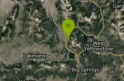
Mile Creek Trail
40.1 miles N
It is important to note that Mile Creek Trail is part of the Continental Divide Trail system, so it connects to other trails of various difficulties. Mile Creek Trail itself is a great...
Mountain Bike
Lake Overlook
Grant Village, Yellowstone National Park
40.3 miles NEThis trail is located in the southern part of the park, with the trailhead in the West Thumb Geyser Basin parking lot. This is about a 1.7 mile hike, roundtrip, that starts and ends at the...
Hike
Grant Village
Grant Village, Yellowstone National Park
40.3 miles EGrant Village was built in 1984 and named after Ulysses S. Grant, president when Yellowstone became the world’s first national park in 1872. Located near the West Thumb of Yellowstone Lake,...
Camp, Canoe, Kayak 0.4 mi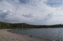
Duck Lake
Grant Village, Yellowstone National Park
40.3 miles NEDuck Lake Trail is located near Grant Village and West Thumb. This is a simple 0.8 miles hike that takes you through the Lodgepole pine forest. This hike is special because the surrounding...
Hike 1.4 mi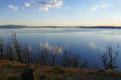
Yellowstone Lake Overlook Trail
Grant Village, Yellowstone National Park
40.4 miles NEYellowstone Lake Overlook Trail is a 1.7 mile loop trail that is easy and great for beginner hikers. The trail begins near the West Thumb Geyser Basin Parking Lot and is open in the summer and fall.
Hike 0.4 mi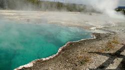
West Thumb Geyser Basin
Grant Visitor's Center, Yellowstone National Park
40.4 miles NEWest Thumb Geyser Basin is one of the smaller geyser basins in Yellowstone, yet its location along the shore of Yellowstone Lake and is ranked as the most scenic. This area was formed by volcanic...
Hike
Kelly Canyon
Ririe, Idaho
40.5 miles SThe trail switchbacks up Kelly Mountain, hitting two brief red-line climbs before you get up on the top. The famed "Shale Chute" is back there somewhere (so this is part of the route for...
Mountain Bike
Rocky Peak Via Spooky Trail
Victor, Idaho
40.5 miles SYou will start up Spooky trail which is the only trail in the parking area. There is a trail junction on your left about 1.2-1.5 just keep going straight. At about 2.6 from TH you'll...
Mountain Bike 3.8 mi
Kelly Mountain Trail
Ririe, Idaho
40.5 miles SKelly Canyon Trail is a moderate, uphill trail that can be used by hikers, mountain bikers, and ATV riders. The trail features views of hills, mountains, trees, wildflowers, and some wildlife. Dogs...
Cross-country Ski, Hike, Mountain Bike, Snowshoe
Poison Flats
Ririe, Idaho
40.6 miles SHike near Ririe, Idaho
Hike 0.1-7.3 mi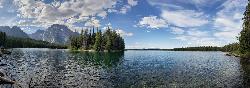
Leigh Lake
Alta, Wyoming
40.6 miles SEEnjoy the grandeur of Grand Teton National Park just a little ways off the beaten path. Leigh Lake rests underneath the majestic Mount Moran. The waters of Leigh Lake flow almost directly into String...
Backpack, Canoe, Hike, Kayak
Lower Hawley Gulch Trail
Ririe, Idaho
40.6 miles SThis is a singletrack biking trail in Ririe, Idaho. The trail is mainly flat with a few gradual slopes. You may have to carry your bike over obstacles such as fallen trees, logs, and small ponds....
Mountain Bike
Grove Creek to Drake Creek
Victor, Idaho
40.7 miles SGreat loop trail that connects several trails through the area. This trail was recently rerouted, and so will have plenty of new switchbacks to take as riders climb the mountain. Originally this...
Mountain Bike
Table Rock Campground
Ririe, Idaho
40.7 miles STable Rock / Poison Flat Campground is located at the Caribou-Targhee National Forest which occupies over 3 million acres and stretches across southeastern Idaho, from the Montana, Utah, and Wyoming...
Camp


