


107 Things to do near Mile Creek Trail
first prev 1 2 3 4 5 6 next lastShowing results within 50 miles Distance miles of 74 Mile Creek Rd, Cameron, MT 59720, USA City, Zip, or Address

Warm River Campground
Ashton, Idaho
44.9 miles SWarm River Campground is located nine miles northeast of Ashton, Idaho, along the slow-moving Warm River at an elevation of 5,200 feet. Willows line the riverbanks and pine trees offer partial...
Camp 3.2-47.0 mi
Yellowstone Branch Line Trail
Ashton, Idaho
44.9 miles SYellowstone branch line trail runs from Warm River to the Montana border totaling 39 miles. There are a few places to jump on and off the trail as well as a few smaller trails that branch off of this...
Backpack, Cross-country Ski, Hike, Horseback, Mountain Bike
Horseshoe Lake
Ashton, Idaho
45.0 miles SHorseshoe Lake is hidden back in the Targhee National Forest. It's a beautiful lake with plenty of lily pads. The road to get there is well maintained and there are many options for pull-outs...
Camp, Canoe, Dive, Swim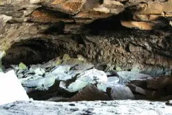
Civil Defense Caves
Rexburg, Idaho
45.0 miles SThe caves are large lava tubes. The name comes from the cold war era when they were anticipated as a safe area in the case of an attack. The entrance is pretty bouldery and does require a small...
Cave
Forces of the Northern Range
Mammoth, Yellowstone National Park
45.2 miles EThis short 1/2 mile boardwalk located on the Blacktail Deer Plateau between Mammoth Village and Tower Junction will open your eyes and educate you about forces of nature that have sculpted the land...
Hike 18.2 mi
Howard Eaton Trail
Canyon Village, Yellowstone National Park
46.4 miles EThe Howard Eaton Trail is a hike with a variety of destinations along a 10 mile trail. The trail can be entered and exited at several points but is most commonly started near Canyon Village. The...
Hike 1.4-2.5 mi
Ribbon Lake Trail
Canyon Village, Yellowstone National Park
46.7 miles ERibbon Lake Trail is a 6-mile trail that leads hikers through beautiful meadows, past colorful lakes and beside Yellowstone River. This trail gives hikers a beautiful view of the Grand Canyon of...
Hike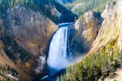
Lower Falls of the Yellowstone
Canyon Village, Yellowstone National Park
46.7 miles ELower Yellowstone Falls is one of the most popular places to visit in Yellowstone, coming in just behind the geyser, Old Faithful. The tallest waterfall in the park, Lower Yellowstone Falls is...
Hike 14.8-30.2 mi
Mr. Bubbles Hot Spring
Old Faithful, Yellowstone National Park
46.8 miles SEMr. Bubbles is one of the few places you can actually soak in the thermal waters of Yellowstone National Park. The Bechler area of Yellowstone is one of the best kept secrets of the otherwise densely...
Hike, Hot Springs
Canyon Campground
Canyon Junction, Yellowstone National Park
47.1 miles ECanyon Campground is a popular choice for visitors to Yellowstone National Park, and it's easy to see why. Located in the heart of the park, the campground offers easy access to some of the...
Camp 7.6 mi
Observation Peak Trail
Canyon Village, Yellowstone National Park
47.2 miles EObservation Peak Trail is one of the most famous hikes in Yellowstone National Park. The hike is an almost 10 miles there and back hike that starts and ends at the same trailhead. Observation...
Hike 2.4 mi
Cascade Lake Trail
Canyon Village, Yellowstone National Park
47.2 miles ECascade Lake Trail is an easy, short hike through picturesque meadows to the beautiful cascade lake. The trailhead is located North of Canyon Village on Grand Loop Road. There is a pullout here where...
Hike 29.6 mi

Ashton to Tetonia Trail
Ashton, Idaho
47.5 miles SThe Idaho Department of Parks and Recreation undertook the project to transform the old Teton Valley Branch of the Union Pacific Railroad from Ashton to Tetonia into a trail for bikes, ATVs, and...
Mountain Bike 9.0 mi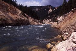
Seven Mile Hole Trail
Canyon Village, Yellowstone National Park
48.0 miles ESeven Mile Hole is a challenging out and back trail that winds along and into the Grand Canyon of Yellowstone. This 10-mile hike begins and ends at Canyon Village where parking is available. From...
Hike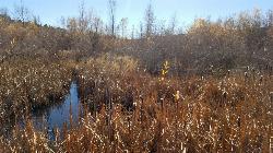
River Rush
Ashton, Idaho
48.0 miles SPaintball near Ashton, Idaho
Paintball
Porcupine Creek
Ashton, Idaho
48.0 miles SPorcupine Creek is a hunting, fishing, camping, and swimming spot near Ashton, Idaho in Fremont County within Targhee National Forest. It's surrounded by forests, meadows, and a creek...
Camp, Swim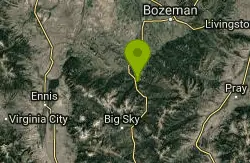
Garnett Mountain
Gallatin Gateway, Montana
48.1 miles NThis is a great singletrack but it is merciless. Just don't make it your first ride of the year. No problems following this trail, just follow the most obvious route. Though not overly...
Mountain Bike
Cave Falls of Yellowstone
Ashton, Idaho
48.3 miles SEThis campgrond is situated on the banks of Fall River in Wyoming along the south border of Yellowstone National Park. Cave Falls Campground has 23 single site units and a terrific area for...
Camp, Hike 3.4 mi
Dunraven Pass - Mount Washburn Trail
Canyon Village, Yellowstone National Park
48.7 miles EHikers looking for a scenic hike to the peak Mount Washburn will be pleased hiking the Mount Washburn Trail via Dunraven Pass. This trail winds through quiet forests to the peak. The trailhead for...
Hike
Falls River, Lower Run
Ashton, Idaho
49.1 miles SFall River rises on the Madison and Pitchstone plateaus in the southwest corner of Yellowstone National Park, Wyoming and flows approximately 64 miles (103 km) to its confluence with the Henrys Fork...
Whitewater


