


205 Things to do near Lorenzo Bridge
first prev 2 3 4 5 6 7 8 9 10 11 next lastShowing results within 50 miles Distance miles of 3987 W 6800 S, Rexburg, ID 83440, USA City, Zip, or Address
River Rush
Ashton, Idaho
29.3 miles NEPaintball near Ashton, Idaho
Paintball
Channel Lock
Driggs, Idaho
29.3 miles ETrail is a little over 1 mile uphill. Recommended route up to access the larger Horseshoe canyon trail system. Makes a nice downhill with twists. Gets its name from the deep ruts made from cows....
Mountain Bike
Sharks Belly
Driggs, Idaho
29.3 miles ETrail system can start from Channel lock or Bovine. Channel Lock is an easier climb than Bovine. This description and mileage starts at the Channel Lock trail, forest service boundary marker. Take...
Mountain Bike
Southbound
Driggs, Idaho
29.3 miles ETrail starts by going up the Channel lock trail. At the top of Channel Lock go right onto the Southbound trail. Trail will loop back to Channel lock which you take back to your car. Trail is...
Mountain Bike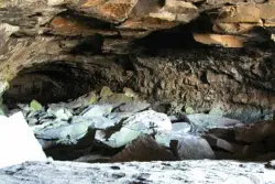
Civil Defense Caves
Rexburg, Idaho
29.5 miles NThe caves are large lava tubes. The name comes from the cold war era when they were anticipated as a safe area in the case of an attack. The entrance is pretty bouldery and does require a small...
Cave
West Pine Creek Trail
Ririe, Idaho
30.9 miles SENon-motorized use. source: fs.usda.gov
Mountain Bike
Trail Canyon Trail
Ririe, Idaho
30.9 miles SEThe Trail Canyon trail begins at Trail Canyon Parklot, T8s R43e Sec28 and ends at Intersect Trail 5251,t8s R43e Sec28. source: fs.usda.gov
Mountain Bike
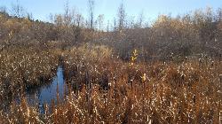
Echo Canyon aka Fall Creek
Ririe, Idaho
31.1 miles SETrail goes to the top of Deadhorse Ridge for some amazing views. Double-track, single-track, and gravel road. Length: 15 miles
Mountain Bike 0.9 mi
Hell's Half Acre Lava Walk
Blackfoot, Idaho
31.4 miles SWThe Lava Trails traverse the desert of the Snake River Plain through contorted landscapes created from multiple lava flows. These Hawaiian-type lava flows are associated with the stretching of the...
Hike
South Fork Fall Creek Trail
Swan Valley, Idaho
31.5 miles SEOHV trail.
Mountain Bike
RPM Wall
Firth, Idaho
31.5 miles SWolverine Canyon is full of limestone. The RPM wall being the currently developed wall and has some decent routes.
Rock Climb 0.1 mi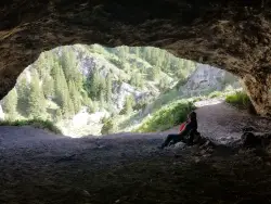
40 Horse Cave
Firth, Idaho
31.5 miles SThe naming of the cave comes from a story of two men who were caught in a bad storm. Upon hiking, these two guys were able to find the cave. One of them commented to the other, "This cave could...
Cave, Hike
Echo/Indian Creek Trail
Swan Valley, Idaho
31.5 miles SEOHV trail. source: fs.usda.gov
Mountain Bike
Fall Creek Falls
Swan Valley, Idaho
31.8 miles SEFalls Campground is located next to the Snake River near beautiful Swan Valley, only 45 miles east of Idaho Falls, Idaho. Mixed growth cottonwood trees provide partial shade, and grassy meadows with...
Camp, Cave, Hike, Kayak, Swim
Twin Creek Trail
Driggs, Idaho
31.8 miles EThe Twin Creek trail is 2.3 miles long. It begins at Trail 6195 and ends at Trail 6219. source: fs.usda.gov
Mountain Bike 29.6 mi
Ashton to Tetonia Trail
Ashton, Idaho
31.9 miles NEThe Idaho Department of Parks and Recreation undertook the project to transform the old Teton Valley Branch of the Union Pacific Railroad from Ashton to Tetonia into a trail for bikes, ATVs, and...
Mountain Bike 0.8 mi
Conant Creek Pegram Truss Railroad Bridge
Ashton, Idaho
32.0 miles NEAs part of the Rails to Trails project, this old railroad bridge has been transformed into a very safe little viewing experience for the whole family. You can drive right up to the bridge where there...
Hike

Falls Campground
Victor, Idaho
32.7 miles SEFalls Campground is located next to the Snake River near beautiful Swan Valley, only 45 miles east of Idaho Falls, Idaho. Mixed growth cottonwood trees provide partial shade, and grassy meadows...
Camp
Henderson Canyon
Victor, Idaho
33.4 miles ETrail begins as dirt road/double track with numerous "cow" trails breaking off of road. Some of these trails see more tire tracks than others.
Mountain Bike
Big Hole Crest Trail
Driggs, Idaho
33.5 miles EThis is a tough ride. Definately for advanced riders. Lots of climbing and descending. The trail at either end is well used and really fun. Not too much technical riding, just fun...
Mountain Bike


