


175 Things to do near Rattle Rock / The Gauntlet
first prev 1 2 3 4 5 6 7 8 9 next lastShowing results within 50 miles Distance miles of Menan Butte Rd, Menan, ID 83434, USA City, Zip, or Address

Ashton to Tetonia Trail
Ashton, Idaho
33.7 miles NEThe Idaho Department of Parks and Recreation undertook the project to transform the old Teton Valley Branch of the Union Pacific Railroad from Ashton to Tetonia into a trail for bikes, ATVs, and...
Mountain Bike 0.8 mi

Conant Creek Pegram Truss Railroad Bridge
Ashton, Idaho
35.1 miles NEAs part of the Rails to Trails project, this old railroad bridge has been transformed into a very safe little viewing experience for the whole family. You can drive right up to the bridge where there...
Hike
Probation And Burg Bumper
Tetonia, Idaho
35.4 miles EThe Probation part of the trail is the steepest downhill in the area. Has multiple bridges and log jumps in the short mile down. The Burg portion of the trail is uphill with some...
Mountain Bike
North Mahogany Trail #220
Tetonia, Idaho
35.9 miles Ehe N. Mahogany Trail is open to Motorbikes, Mountain bikes, Horses, and Hikers. Motorbikes and Horseback riders are the most common visitors, but the trail is becoming increasingly...
Mountain Bike
South Fork Snake River Trail
Ririe, Idaho
36.2 miles SEGo left at the trail head. It heads down about a mile and a half on double track. Then you'll come to a creek crossing. After the crossing the trail heads across a gate. Head left...
Mountain Bike
Firth River Bottoms
Firth, Idaho
36.3 miles SWhether you like to ride horses, picnic, camp, fish, learn about the past, or play baseball, this park has something for everyone. The Parks & Recreation Department and the IDaho Education...
Camp, Canoe, Hike
Horseshoe Canyon
Tetonia, Idaho
36.5 miles EHorseshoe Canyon is one of the closest trail systems to the town of Driggs, Idaho. This network doesn't have a ton of climbing or descending, but the smooth, swooping singletrack with a...
Mountain Bike
Bovine
Driggs, Idaho
36.6 miles EBovine trail is part of a larger system. You can use it to access more trails or make it your end destination from other trailheads. It is a steep climb but returns the favor with a fast downhill....
Mountain Bike
Horseshoe Trails
Driggs, Idaho
36.6 miles EMountain Bike near Driggs, Idaho
Mountain Bike
Ashton Hill
Ashton, Idaho
36.6 miles NEFairly thick forest. Considerable underbrush. Lots of places in the area to play.
Airsoft, Paintball
Channel Lock
Driggs, Idaho
37.0 miles ETrail is a little over 1 mile uphill. Recommended route up to access the larger Horseshoe canyon trail system. Makes a nice downhill with twists. Gets its name from the deep ruts made from cows....
Mountain Bike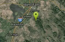
RPM Wall
Firth, Idaho
37.0 miles SWolverine Canyon is full of limestone. The RPM wall being the currently developed wall and has some decent routes.
Rock Climb 0.1 mi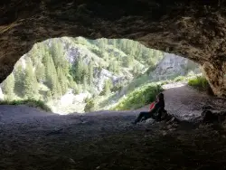
40 Horse Cave
Firth, Idaho
37.0 miles SThe naming of the cave comes from a story of two men who were caught in a bad storm. Upon hiking, these two guys were able to find the cave. One of them commented to the other, "This cave could...
Cave, Hike
Sharks Belly
Driggs, Idaho
37.1 miles ETrail system can start from Channel lock or Bovine. Channel Lock is an easier climb than Bovine. This description and mileage starts at the Channel Lock trail, forest service boundary marker. Take...
Mountain Bike
Southbound
Driggs, Idaho
37.1 miles ETrail starts by going up the Channel lock trail. At the top of Channel Lock go right onto the Southbound trail. Trail will loop back to Channel lock which you take back to your car. Trail is...
Mountain Bike
Big Bend Ridge Trail
Ashton, Idaho
37.5 miles NETrail is open to OHVs. source: fs.usda.gov
Mountain Bike
Hell's Half Acre Southbound Rest Stop
Blackfoot, Idaho
37.6 miles SThis is a well maintained rest area with facilities to keep you happy as you travel through Idaho. This rest stop on Interstate 15 about 15 miles South of Idaho Falls has nice picnic tables and...
Hike
Hell's Half Acre Northbound Rest Stop
Blackfoot, Idaho
37.7 miles SThis is a well maintained rest area with facilities to keep you happy as you travel through Idaho. This rest stop on Interstate 15 about 9 miles north of Blackfoot Idaho has nice picnic tables and...
Hike
The Playground
Shelley, Idaho
38.2 miles SThe Playground is a fun, moderate to hard place to sport rock climb. You can find approximately nine routes (popular ones include: Tied to the Whipping Post, Cure for the Hangover, Anchored to...
Rock Climb
Twin Creek Trail
Driggs, Idaho
39.7 miles EThe Twin Creek trail is 2.3 miles long. It begins at Trail 6195 and ends at Trail 6219. source: fs.usda.gov
Mountain Bike


