


228 Things to do near Driggs, Idaho
first prev 3 4 5 6 7 8 9 10 11 12 next lastShowing results within 50 miles Distance miles of Driggs, ID, USA City, Zip, or Address

Union Falls & Ouzel Pool
Grant Village, Yellowstone National Park
28.9 miles NBackpack, Hike, Hot Springs, and Swim near Grant Village, Yellowstone National Park
Backpack, Hike, Hot Springs, Swim
Monkey Rock
Saint Anthony, Idaho
29.0 miles NWCLOSED. PSA: Monkey Rock is no longer open to the public. The owner has posted "No Trespassing" signs and is asking the Fremont County Sheriff's Office to assist with keeping people out of their...
Swim
Warm River Campground
Ashton, Idaho
29.2 miles NWarm River Campground is located nine miles northeast of Ashton, Idaho, along the slow-moving Warm River at an elevation of 5,200 feet. Willows line the riverbanks and pine trees offer partial...
Camp 29.6 mi
Ashton to Tetonia Trail
Ashton, Idaho
29.2 miles NWThe Idaho Department of Parks and Recreation undertook the project to transform the old Teton Valley Branch of the Union Pacific Railroad from Ashton to Tetonia into a trail for bikes, ATVs, and...
Mountain Bike 3.2-47.0 mi
Yellowstone Branch Line Trail
Ashton, Idaho
29.2 miles NYellowstone branch line trail runs from Warm River to the Montana border totaling 39 miles. There are a few places to jump on and off the trail as well as a few smaller trails that branch off of this...
Backpack, Cross-country Ski, Hike, Horseback, Mountain Bike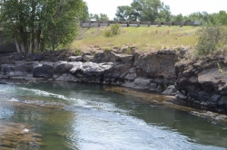
Fall River Bridge
Ashton, Idaho
29.2 miles NWRight off Highway 20, there's a great spot to swim, swing, and dive. There's pullouts for parking right next to the bridge. There's a rope swing under the railroad bridge and a little...
Dive, Swim
Cave Falls of Yellowstone
Ashton, Idaho
29.5 miles NThis campgrond is situated on the banks of Fall River in Wyoming along the south border of Yellowstone National Park. Cave Falls Campground has 23 single site units and a terrific area for...
Camp, Hike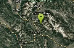
Cache Creek Trial
Jackson, Wyoming
29.6 miles SEHilly terrain with an elevation gain/loss of 850’. Groomed 4.6 miles to Noker Mine Draw on Monday, Wednesday and Friday, generally in the morning. Snowmobiles are allowed on the Cache Creek...
Hike 14.8-30.2 mi
Mr. Bubbles Hot Spring
Old Faithful, Yellowstone National Park
29.6 miles NMr. Bubbles is one of the few places you can actually soak in the thermal waters of Yellowstone National Park. The Bechler area of Yellowstone is one of the best kept secrets of the otherwise densely...
Hike, Hot Springs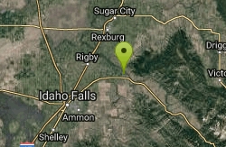
Big Feeder
Ririe, Idaho
29.8 miles WKayak near Ririe, Idaho
Kayak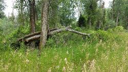
On the banks by Heise
Ririe, Idaho
29.9 miles WOn the banks of the river near Heise. Plenty of trees and ground cover.
Airsoft, Paintball
Marshall's
Saint Anthony, Idaho
30.3 miles NWMarshall's Wave is located on the North Fork of the Teton River, where the Teton River splits into the north and south forks. The wave is created by a headgate and is best at flows above 600...
Kayak

Horseshoe Lake
Ashton, Idaho
30.3 miles NHorseshoe Lake is hidden back in the Targhee National Forest. It's a beautiful lake with plenty of lily pads. The road to get there is well maintained and there are many options for pull-outs...
Camp, Canoe, Dive, Swim
Twin Bridges
St. Anthony, Idaho
30.6 miles NWThere's an old abandoned bridge next to the one currently in use. The water is pretty deep underneath and offers two distinct levels to jump from. There's a little rope swing under the bridge...
Dive, Swim 0.3-0.6 mi
Cress Creek Nature Trail
Rexburg, Idaho
30.7 miles WMeandering along the scenic South Fork of the Snake River, the beautiful 1¼ mile Cress Creek Nature Trail will lead you on a journey through sagebrush-grass communities, over juniper covered...
Hike 0.3-0.6 mi
Bear Gulch
Ashton, Idaho
30.8 miles NBear Gulch is an abandoned ski hill out of operation since 1969. While the vegetation is beginning to take over, there's still some great sledding to be had. It's just far enough into the...
Camp, Cross-country Ski, Hike, Sled 1.9 mi
Terraced Falls
Grant Village, Yellowstone National Park
30.9 miles NE3.6 mile easy out and back trail. 430 ft Elevation gain. The trailhead is off Ashton-Flagg Ranch Road along Yellowstone's South border. Ashton-Flagg Ranch Road is closed during the winter.
Hike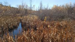
River Rush
Ashton, Idaho
31.1 miles NWPaintball near Ashton, Idaho
Paintball
The Pit
Ashton, Idaho
31.1 miles NThis location is great because there is no one around only locals know of this area and you can shoot anything out there. Watch out for target shooters there! Also stay away from the main road.
Airsoft, Paintball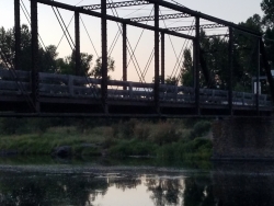
Fun Farm Bridge
Saint Anthony, Idaho
31.2 miles NWAlso known as the Funny Farm Bridge, this is an excellent place for bridge jumping. You can jump from the road level, the top of the bridge, or swing from the bars below. Just be watchful of cars...
Dive, Swim


