


Map of 109 Things to do near Dubois, Idaho
first prev 1 2 3 4 5 6 next lastShowing results within 50 miles Distance miles of Dubois, ID 83423, USA City, Zip, or Address

Mesa Falls
Ashton, Idaho
44.8 miles EUpper Mesa Falls, aka Big Falls, is an absolutely awesome waterfall on the Henrys Fork of the Snake River. The falls drop 114 ft. and measure 300 ft. across. To get to the falls from the parking lot...
Cross-country Ski, Hike, Kayak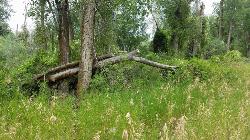
On the banks by Heise
Ririe, Idaho
45.4 miles SEOn the banks of the river near Heise. Plenty of trees and ground cover.
Airsoft, Paintball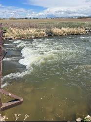
The Junk Field Wave
Idaho Falls, Idaho
45.7 miles SKayak near Idaho Falls, Idaho
Kayak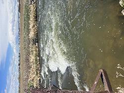
Double Tap wave feature
Idaho Falls, Idaho
45.7 miles SIt's a fun little double feature in an irrigation canal the first is a open elevation control dam that throws a nice wave and foam pile off of it great for freestyle kayaking then about 30 yards...
Canoe, Kayak 3.2-47.0 mi
Yellowstone Branch Line Trail
Ashton, Idaho
45.8 miles EYellowstone branch line trail runs from Warm River to the Montana border totaling 39 miles. There are a few places to jump on and off the trail as well as a few smaller trails that branch off of this...
Backpack, Cross-country Ski, Hike, Horseback, Mountain Bike 0.5-3.5 mi
Webster's Dam
Ririe, Idaho
45.8 miles SEAlso known as Manmade Falls or the Woodmansee Dam, Webster Dam is an abandoned dam located deep in Moody Creek canyon, the dam was abandoned when sediment built up behind the dam which then...
Camp, Hike, Mountain Bike

Warm River Campground
Ashton, Idaho
45.9 miles EWarm River Campground is located nine miles northeast of Ashton, Idaho, along the slow-moving Warm River at an elevation of 5,200 feet. Willows line the riverbanks and pine trees offer partial...
Camp 0.9 mi
Buffalo River Campground
Island Park, Idaho
46.2 miles EThe float here is nice and easy. It's a great early season float. Later in the season the shallow spots will force you to walk a good chunk of the float. The water is super clear and often pretty...
Camp, Canoe, Kayak, Swim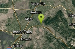
Big Feeder
Ririe, Idaho
46.3 miles SEKayak near Ririe, Idaho
Kayak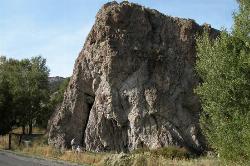
Heise Rock (AKA Elephant Rock)
Ririe, Idaho
46.6 miles SECLOSED. Rock climbing is no longer permitted. This volcanic plug sits just off the road near the Heise Hot Springs Golf Course. It is also referred to as Elephant Rock or Chuck's Choss Pile. Aid...
Rock Climb
Freeman Park
Idaho Falls, Idaho
46.6 miles SA couple of creek crossings add to appeal. Snake river borders most of this beautifully maintained course. Good elevation and variety. Public (No Fee)
Disc Golf 7.6 mi
Mount Jefferson
Island Park, Idaho
46.7 miles NEMount Jefferson, at 10, 203 feet is the highest point in the Centennial Mountains, a small, local range on the border of Idaho and Montana a little west of Yellowstone. These mountains consist of a...
Hike 4.2 mi
Lake Marie
Island Park, Idaho
46.7 miles NELake Marie sits on the North slope of Mount Jefferson in Fremont County, Idaho. The trail to get there cuts back and forth across the Idaho Montana border 4 times. Much of the trail is fairly flat...
Backpack, Hike
Sawtell Peak Trail
Island Park, Idaho
46.7 miles NEThis trail offers great views of the valley floor, mountain peaks and wildlife. source: fs.usda.gov
Mountain Bike
Big Hole Dispersed Campsites
Ririe, Idaho
46.7 miles SEA dispersed campsite is simply an unestablished and unmaintained area where people camp. Often, this means that there is a campfire or other basic campsite feature to identify the site and that's...
Camp 0.3-0.6 mi
Bear Gulch
Ashton, Idaho
46.9 miles EBear Gulch is an abandoned ski hill out of operation since 1969. While the vegetation is beginning to take over, there's still some great sledding to be had. It's just far enough into the...
Camp, Cross-country Ski, Hike, Sled
The Pit
Ashton, Idaho
46.9 miles EThis location is great because there is no one around only locals know of this area and you can shoot anything out there. Watch out for target shooters there! Also stay away from the main road.
Airsoft, Paintball 2.1 mi
Batman
Ririe, Idaho
47.0 miles SEThis trail features rolling terrain, and multiple short, steep downhill sections followed by short steep uphill sections. This trail follows the fence line. Watch out for cows (and cow droppings)...
Mountain Bike
Paramount Wall / Blanche Rock
Ririe, Idaho
47.1 miles SESitting high above the road, the routes at Paramount offer great exposure and relief from the afternoon summer sun. Chuck Oddette, Steve Reiser and Jed Miller established the routes from 1989...
Camp, Horseback, Rock Climb 1.7 mi
Randy's Cow Trail / Ken's Corner
Ririe, Idaho
47.1 miles SEThis trail descends from the fence corner at the West end of Batman and continues down to Lyon's Creek Parking just off Lyon's road. The top of this trail is only a couple hundred yards from...
Mountain Bike


