


56 Things to do near Groveland, California
first prev 1 2 3 next lastShowing results within 50 miles Distance miles of Groveland, CA, USA City, Zip, or Address

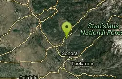
Sonora Skate Park
Sonora, California
12.5 miles NWLocated in Tuolumne County, California, Sonora skate park is great outdoor facility with bowls, rails and some corner spots to grind and do tricks. Everyone must wear a helmet and other...
Skateboard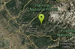
Gods Bath
Phoenix Lake-Cedar Ridge, CA, California
14.0 miles NEGod's Bath swimming hole in the Clavey River is a beautiful and popular location to take a dive in. However, the hike to get there is about one mile of rock climbing. The trailhead begins on...
Hike, Swim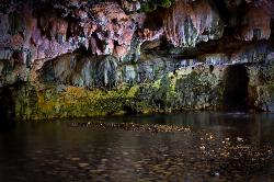
Natural Bridges
Sonora, California
19.7 miles NWNatural Bridges is well known among the locals of Calaveras County. Calavers itself has many caverns throughout the mountains, but most are fee based. Natural Bridges however, is open to the...
Hike, Swim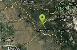
Briceburg Recreation Area
Midpines, California
21.6 miles SECamp, Kayak, and Swim near Midpines, California
Camp, Kayak, Swim
Hite Cove Trail
El Portal, California
23.0 miles SEThis hike is popular among wildflower enthusiasts. Located in Yosemite National Park, Hite Cove trail is one of the areas that blooms earliest for wildflowers. While areas in the high country...
Hike, Swim
Feeney
Murphys, California
23.3 miles NWFun course in a park around parkinglot, soccer/ball fields and skatepark. Some short technical holes and some longer distance throws. Public (No Fee)
Disc Golf
Feeney Park
Murphys, California
23.5 miles NWFeeney Park is a multi-use recreational facility and community park. The Park is open to the public year-round during daylight hours. Feeney Park is the only facility of its kind along the Highway 4...
Skateboard
Crane Flat
Big Oak Flat, Yosemite National Park
24.4 miles ECrane Flat Campground is a meadow and forest between Tuolumne and Merced Groves of Giant Sequoias. The campground is 30 minutes outside Yosemite Valley, has restrooms and picnic...
Backpack, Camp, Hike, Snowshoe 4.7 mi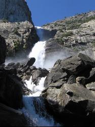
Wapama Falls
Groveland, California
25.3 miles EA 5 mile hike along the shoreline of the Hetch Hetchy reservoir will take you to one of Yosemite's famous waterfalls. The hike to the fall is moderate, takes about 2.5-5 hours to...
Backpack, Hike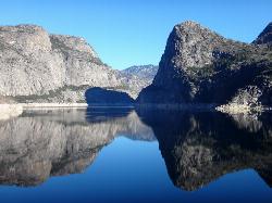
Hetch Hetchy Reservoir
Groveland, California
25.5 miles ELocated thirty minutes outside Yosemite Valley, Hetch Hetchy has the longest hiking season in the park. It's home to the O'Shaughnessy Dam and Wapama Falls. Since...
Backpack, Hike
White Pines Park Disc Golf Course
Arnold, California
29.8 miles NA Bret Harte High School senior project over the beautiful and challenging terrain of White Pines Park. Bring the map to navigate. Avoid holes near the parking lot when it is full. Some tones but...
Disc Golf
White Pines Lake
Arnold, California
30.5 miles NLaid out along end of a lake and around the softball field. 9 tones and 9 Mach V baskets. A high school project with 9 donated baskets. Some elevation and mix of open to tight pin positions. Public...
Disc Golf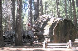
Calaveras Big Trees State Park
Arnold, California
30.6 miles NCalaveras Big Trees State Park is a little known grove of Sequoias located in the beautiful Northern California gold country. The area became a State Park in 1931 in order to preserve the trees...
Hike
Harden Lake
Big Oak Flat, Yosemite National Park
31.8 miles EThe hike to Harden Lake at Yosemite is essentially a long walk. Much of the trail is walking down Tioga Road, an old gravel street that has been part of Yosemite since its foundation. The trail is...
Backpack, Hike 0.2 mi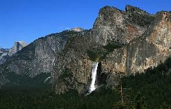
Bridalveil Falls
Yosemite Valley, Yosemite National Park
33.0 miles EKnown for being the focal point for one of Ansel Adams' most famous photographs, Bridalveil Falls is one of the first waterfalls you see as you enter Yosemite. The path to get there...
Hike 0.2 mi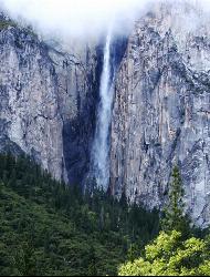
Ribbon Falls
Yosemite Valley, Yosemite National Park
33.2 miles EStanding at 1612 ft tall, Ribbon Falls is one of the tallest waterfalls in Yosemite Valley and the longest single-drop waterfall in North America. It's visible from El Capitan road as you...
Hike 0.7 mi
Lukens Lake
Tuolumne Meadows, Yosemite National Park
33.6 miles ELukens Lake is a small lake in the White Wolf area of Yosemite National Park. The hike is a short, 1.6 mile walk through a forest to the secluded lake surrounded by trees and a small...
Hike, Swim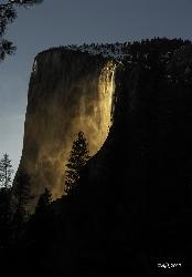
Horsetail Falls
Yosemite Valley, Yosemite National Park
33.8 miles EHorsetail Falls is located near El Capitan Valley in Yosemite. Around mid to late February, the fall gains popularity due to the way the orange glow of the sunset radiates off of it. In order to...
Hike 15.9 mi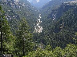
Valley Loop Trail
Yosemite Valley, Yosemite National Park
34.7 miles EThe Valley Loop trail at the heart of Yosemite is one of the best ways to discover the park. The entire loop is 11.5 miles long, and there are several places to enter and exit the trail...
Hike 0.5 mi
McGurk Meadow
Yosemite National Park
34.9 miles EMcGurk Meadow is a short, 0.8 mile hike through one of Yosemite's wildflower meadows. The trail is fairly flat, about 100 feet of elevation gain, and it doesn't require too much effort,...
Hike


