


217 Things to do near Irwin, Idaho
first prev 1 2 3 4 5 6 7 8 9 10 next lastShowing results within 50 miles Distance miles of Irwin, ID, USA City, Zip, or Address

North Mahogany Trail #220
Tetonia, Idaho
21.5 miles Nhe N. Mahogany Trail is open to Motorbikes, Mountain bikes, Horses, and Hikers. Motorbikes and Horseback riders are the most common visitors, but the trail is becoming increasingly...
Mountain Bike
Poison Flats
Ririe, Idaho
21.5 miles NWHike near Ririe, Idaho
Hike
Bovine
Driggs, Idaho
21.7 miles NBovine trail is part of a larger system. You can use it to access more trails or make it your end destination from other trailheads. It is a steep climb but returns the favor with a fast downhill....
Mountain Bike
Horseshoe Trails
Driggs, Idaho
21.7 miles NMountain Bike near Driggs, Idaho
Mountain Bike 0.3 mi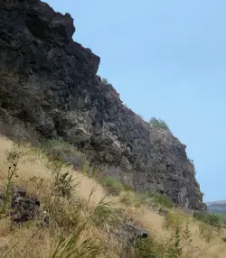
Pointless Crag
Ririe, Idaho
21.7 miles NWNO MORE BOLTING as of 5/2012 requested by the Bureau of Land Management. The BLM has asked us NOT to park on the road below the cliff. Please use the obvious parking area next to the river...
Rock Climb 1.8 mi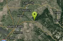
Crystal Cruise
Ririe, Idaho
21.7 miles NWThis trail uses the Crystal Cruise Nordic Trail along the Kelly Canyon ski resort boundary, taking you up to Kelly Canyon proper. It's a good climb, and a quick downhill back to the parking...
Mountain Bike
Horseshoe Canyon
Tetonia, Idaho
21.7 miles NHorseshoe Canyon is one of the closest trail systems to the town of Driggs, Idaho. This network doesn't have a ton of climbing or descending, but the smooth, swooping singletrack with a...
Mountain Bike 0.6-2.2 mi

Fish Creek Area
Ririe, Idaho
21.9 miles NWFish Creek is a network of mountain bike trails up in the Big Hole Mountains. The trails are easily accessed from either the Ririe or Rexburg side of the range. The trail system is set up much...
Hike, Mountain Bike
Channel Lock
Driggs, Idaho
22.0 miles NTrail is a little over 1 mile uphill. Recommended route up to access the larger Horseshoe canyon trail system. Makes a nice downhill with twists. Gets its name from the deep ruts made from cows....
Mountain Bike 1.1 mi
Hidden Vista / Pine Loop
Ririe, Idaho
22.0 miles NWYou'll find the Hidden Vista trailhead on the South End of the Buckskin Morgan parking lot about a mile past Y Junction. This is a short trail with a little up and a little down for just under a...
Hike, Mountain Bike 5.7-8.1 mi
Space Cruz
Ririe, Idaho
22.0 miles NWThe trail starts out with a really flowy singletrack then connects up to some ATV trails. On the single track, just stay on the main trail. There are several little splits several you can take...
Cross-country Ski, Mountain Bike
Southbound
Driggs, Idaho
22.0 miles NTrail starts by going up the Channel lock trail. At the top of Channel Lock go right onto the Southbound trail. Trail will loop back to Channel lock which you take back to your car. Trail is...
Mountain Bike 1.7 mi
Buckskin Morgan Ridge
Ririe, Idaho
22.0 miles NWGoing up is a little tough because of the rocks, but once you clear the top it is a twisty down hill portion [until] you get to a fenced road. From there you can turn around or keep going strait...
Hike, Mountain Bike
Sharks Belly
Driggs, Idaho
22.0 miles NTrail system can start from Channel lock or Bovine. Channel Lock is an easier climb than Bovine. This description and mileage starts at the Channel Lock trail, forest service boundary marker. Take...
Mountain Bike 3.8 mi
Kelly Mountain Trail
Ririe, Idaho
22.2 miles NWKelly Canyon Trail is a moderate, uphill trail that can be used by hikers, mountain bikers, and ATV riders. The trail features views of hills, mountains, trees, wildflowers, and some wildlife. Dogs...
Cross-country Ski, Hike, Mountain Bike, Snowshoe 2.7 mi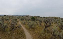
Sidewinder Trail
Ririe, Idaho
22.3 miles NWSidewinder's claim to fame is that it's on a South facing hill just above the Snake River. That means that when all the other trails in the Kelly Canyon Trail network are covered with snow...
Mountain Bike 3.8 mi
Stinking Springs
Ririe, Idaho
22.3 miles NWStinking Springs is a great early to late season trail. Being at the edge of the Big Hole range, it gets spring earlier and winter later than other trails in the range. It's closed from December...
Hike, Mountain Bike 11.9 mi
Waterfall Loop
Ririe, Idaho
22.3 miles NWTrail is a mixture of single track, forest road and double track. Provides a variety of scenery. About 1400 feet of elevation change throughout the trail.GPS is a must unless you are going with...
Mountain Bike
Kelly Canyon Loops
Ririe, Idaho
22.7 miles NWThis mountain bike trail near Kelly Canyon Ski Area has several options available. Highlights are the views in all directions from the top of the mountain. Trails: Waterfall...
Mountain Bike
Darby Canyon Camping
Alta, Wyoming
23.0 miles NEThere's no official campgrounds up the canyon but there are several dispersed campsites with existing fire lays. Please adhere to principles of Leave No Trace. Use existing fire lays and leave...
Camp


