


Map of 215 Things to do near Rexburg, Idaho
first prev 1 2 3 4 5 6 7 8 9 10 next lastShowing results within 50 miles Distance miles of Rexburg, ID, USA City, Zip, or Address
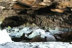
Civil Defense Caves
Rexburg, Idaho
23.0 miles NThe caves are large lava tubes. The name comes from the cold war era when they were anticipated as a safe area in the case of an attack. The entrance is pretty bouldery and does require a small...
Cave
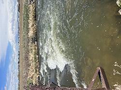
Double Tap wave feature
Idaho Falls, Idaho
23.2 miles SWIt's a fun little double feature in an irrigation canal the first is a open elevation control dam that throws a nice wave and foam pile off of it great for freestyle kayaking then about 30 yards...
Canoe, Kayak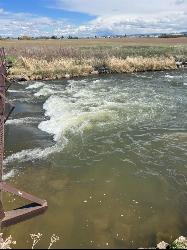
The Junk Field Wave
Idaho Falls, Idaho
23.2 miles SWKayak near Idaho Falls, Idaho
Kayak
Blacks Canyon Trail
Ririe, Idaho
23.4 miles SEThe Blacks Canyon trail begins at Black Can Road and ends at Junction Fleming Canyon Trail. The trail is open for the following uses: Motorcycle Trail Riding, Off Highway Vehicles (OHV)...
Mountain Bike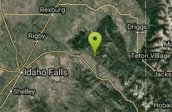
South Fork Rim Trail
Ririe, Idaho
23.4 miles SEMotorcycle trail. source: fs.usda.gov Courtesy of Singletracks.com
Mountain Bike
Probation And Burg Bumper
Tetonia, Idaho
24.7 miles EThe Probation part of the trail is the steepest downhill in the area. Has multiple bridges and log jumps in the short mile down. The Burg portion of the trail is uphill with some...
Mountain Bike 29.6 mi
Ashton to Tetonia Trail
Ashton, Idaho
24.9 miles NEThe Idaho Department of Parks and Recreation undertook the project to transform the old Teton Valley Branch of the Union Pacific Railroad from Ashton to Tetonia into a trail for bikes, ATVs, and...
Mountain Bike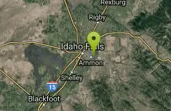
Eagle Point Park
Ammon, Idaho
25.0 miles SPractice course with 3 baskets and 3 tees. Play each basket from each tee for 9 holes. Playground nearby. Private (No Fee)
Disc Golf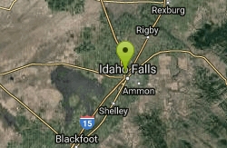
Freeman Park
Idaho Falls, Idaho
25.0 miles SWA couple of creek crossings add to appeal. Snake river borders most of this beautifully maintained course. Good elevation and variety. Public (No Fee)
Disc Golf 0.8 mi
Conant Creek Pegram Truss Railroad Bridge
Ashton, Idaho
25.3 miles NEAs part of the Rails to Trails project, this old railroad bridge has been transformed into a very safe little viewing experience for the whole family. You can drive right up to the bridge where there...
Hike
North Mahogany Trail #220
Tetonia, Idaho
25.4 miles Ehe N. Mahogany Trail is open to Motorbikes, Mountain bikes, Horses, and Hikers. Motorbikes and Horseback riders are the most common visitors, but the trail is becoming increasingly...
Mountain Bike
McCowin Park Disc Golf Course
Ammon, Idaho
25.5 miles SShort - longest hole 333'. A few trees and fences for obstacles. Good for a quick game. Public (No Fee)
Disc Golf 1.0-7.5 mi
Idaho Falls Greenbelt
Idaho Falls, Idaho
25.8 miles SWThe Idaho Falls Greenbelt is one of Idaho Falls charms located in the heart of Idaho Falls, next to the historic Idaho Falls downtown. The paved foot-trail is approximately 6 miles around,...
Hike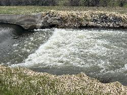
Street kid rapid
Idaho Falls, Idaho
25.8 miles SWA good short rock garden to try out a new whitewater kayak or learn how to whitewater kayak . It's in a canal in the middle of town and in the spring there can be a lot of water running over this...
Canoe, Kayak
Horseshoe Canyon
Tetonia, Idaho
25.9 miles EHorseshoe Canyon is one of the closest trail systems to the town of Driggs, Idaho. This network doesn't have a ton of climbing or descending, but the smooth, swooping singletrack with a...
Mountain Bike
Bovine
Driggs, Idaho
26.0 miles EBovine trail is part of a larger system. You can use it to access more trails or make it your end destination from other trailheads. It is a steep climb but returns the favor with a fast downhill....
Mountain Bike
Horseshoe Trails
Driggs, Idaho
26.0 miles EMountain Bike near Driggs, Idaho
Mountain Bike
Channel Lock
Driggs, Idaho
26.4 miles ETrail is a little over 1 mile uphill. Recommended route up to access the larger Horseshoe canyon trail system. Makes a nice downhill with twists. Gets its name from the deep ruts made from cows....
Mountain Bike
Sharks Belly
Driggs, Idaho
26.5 miles ETrail system can start from Channel lock or Bovine. Channel Lock is an easier climb than Bovine. This description and mileage starts at the Channel Lock trail, forest service boundary marker. Take...
Mountain Bike
Southbound
Driggs, Idaho
26.5 miles ETrail starts by going up the Channel lock trail. At the top of Channel Lock go right onto the Southbound trail. Trail will loop back to Channel lock which you take back to your car. Trail is...
Mountain Bike


