


209 Things to do near Ririe, Idaho
first prev 2 3 4 5 6 7 8 9 10 11 next lastShowing results within 50 miles Distance miles of Ririe, ID, USA City, Zip, or Address
Alta Nordic Trail
Alta, Wyoming
37.8 miles EDistance: 6.2 miles (10km) Trail Map: Alta_Nordic_Trail_2015.pdf Grooming Report: http://tvtap.org/nordic-grooming
Cross-country Ski, Snowshoe
Bitch Creek Trestle
Tetonia, Idaho
38.1 miles NEAs part of the Rails to Trails project, this old railroad bridge has been transformed into a very safe little viewing experience for the whole family. You can drive right up to the bridge where...
Hike
Big Elk Campground
Irwin, Idaho
39.4 miles SEBig Elk Creek Campground is a very versitile campground with plenty of activities to keep busy. Campgrounds are available, with three group sites that include picnic tables and campfire rings. There...
Camp 13.8 mi
Big Elk Creek
Irwin, Idaho
39.4 miles SEBig Elk Creak Campground is a very versitile campground with plenty of activities to keep busy. Campgrounds are available, with three group sites that include picnic tables and campfire rings. There...
Backpack, Camp, Canoe, Hike, Horseback, Kayak 23.8 mi
Big Elk Creek Trail
Irwin, Idaho
39.5 miles SENon-motorized trail open to MTB. source: fs.usda.gov
Mountain Bike

Grand Targhee Resort
Moose, Wyoming
39.6 miles ESpectacular Teton mountain course at 8000' elevation. Discs in Activity Center. Head bartender in resort's Trap Bar is the course pro. Course open when snow is gone; usually June to...
Disc Golf
Cold Springs
Moose, Wyoming
39.7 miles ETrail is easiet down as a loop but can be done as a shuttle as well. Take a right into Teton Canyon and park at the first big parking lot on the left. About 50 yards from Ski Hill rd....
Mountain Bike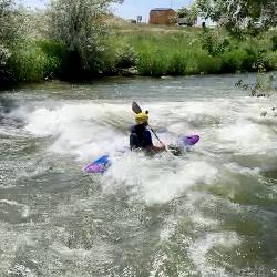
Groveland Wave
Blackfoot, Idaho
39.8 miles SWWave in a canal located at Groveland. It's a great little spot to practice. ISU uses it for training beginning/intermediate whitewater kayaking, river safety and swiftwater rescue.
Kayak
Falls River, Lower Run
Ashton, Idaho
39.9 miles NEFall River rises on the Madison and Pitchstone plateaus in the southwest corner of Yellowstone National Park, Wyoming and flows approximately 64 miles (103 km) to its confluence with the Henrys Fork...
Whitewater
Ashton Hill
Ashton, Idaho
40.2 miles NEFairly thick forest. Considerable underbrush. Lots of places in the area to play.
Airsoft, Paintball 7.1 mi
Mill Creek Trail
Moose, Wyoming
40.2 miles EThere are two ways to do this ride, one as a loop with the Targhee road providing the bulk of the climb, or as an out and back (up the trail and back down). Keep in mind that this trail is...
Cross-country Ski, Mountain Bike, Snowshoe 4.5 mi
Sheep Bridge Trail
Driggs, Idaho
40.2 miles EThis is a great easy trail for beginner hikers or mountain bikers. In the early summer, you'll find many beautiful wildflowers and large kaleidoscopes of butterflies to go with them. You...
Hike, Mountain Bike 4.6 mi
Coal Creek Trail
Alta, Wyoming
40.3 miles EEnjoy outstanding views from upper Coal Creek Meadows, this hike description travels just beyond the meadows to the top of Coal-Mesquite Divide where you'll enjoy some rather dramatic views of...
Hike, Mountain Bike 0.1-6.2 mi
Darby Wind Cave
Driggs, Idaho
40.4 miles EDarby Wind Cave is a beautiful hike full of waterfalls, wildflowers, streams, and mountainous views. The sites you see will depend on the time of year you visit but it will always be beautiful and...
Backpack, Cave, Hike, Rock Climb
Sand Creek Frenzy
Ashton, Idaho
40.4 miles NThere are some woods back there and it is secluded. There are many places you can play just watch out for campers.
Paintball 3.2-47.0 mi
Yellowstone Branch Line Trail
Ashton, Idaho
40.8 miles NEYellowstone branch line trail runs from Warm River to the Montana border totaling 39 miles. There are a few places to jump on and off the trail as well as a few smaller trails that branch off of this...
Backpack, Cross-country Ski, Hike, Horseback, Mountain Bike
Warm River Campground
Ashton, Idaho
40.9 miles NEWarm River Campground is located nine miles northeast of Ashton, Idaho, along the slow-moving Warm River at an elevation of 5,200 feet. Willows line the riverbanks and pine trees offer partial...
Camp
Porcupine Creek
Ashton, Idaho
41.8 miles NEPorcupine Creek is a hunting, fishing, camping, and swimming spot near Ashton, Idaho in Fremont County within Targhee National Forest. It's surrounded by forests, meadows, and a creek...
Camp, Swim
Blackfoot Skatepark
Blackfoot, Idaho
41.8 miles SWThis 18000-square-foot-concrete park has a bowl area with a pyramid in the middle and a street course consisting of a four-step rail, two funboxes, and quarterpipes all around. They also have a...
Skateboard
Blackfoot, ID 83221, United States
Blackfoot, Idaho
41.9 miles SWHike and Mountain Bike near Blackfoot, Idaho
Hike, Mountain Bike


