


2.0K 1 by camilledupar
first prev 1 next last
Horseshoe Lake
Ashton, Idaho
18.3 miles E of Ashton, IdahoHorseshoe Lake is hidden back in the Targhee National Forest. It's a beautiful lake with plenty of lily pads. The road to get there is well maintained and there are many options for pull-outs and parking once you get there. The lake has a gradual decline great for wading but has plenty deep enough for swimming and canoeing. A youth camp has a floating dock out towards the middle that is often free to use for jumping in. The lake is also a great place to go fishing. No motorized boats are allowed.

Big Springs
Island Park, Idaho
7.6 miles NE of Island Park, IdahoThere's also a great little walking trail along the river with placards that tell about the ecosystem and history of the area. There's about a 1/2 mile that's paved and then a 1/2 mile of dirt trail. The trail is NOT a loop. The trailhead is on the South West side of the bridge. There's a great spot to feed the fish under the West side of the bridge so bring some quarters to buy fish food. The trail to Johnny Sack's Cabin is on the North Side of the Cabin.
Campground (Fee Required)
This campground Is located on the Ashton·lsland Park Ranger District, comprising nearly 650,000 acres of National Forest System lands. Numerous amenities are offered such as single and double sites which Includes fire rings. utlllty tables. picnic tables, and reslrooms. This campground is situated nen to the beautiful Henry's Fork shaded by Lodgepole Pines. Come In and relax with friends and family. Head on out and explore the Big Springs Interpretative Trail which starts at the bridge Just Outside the campground. Be sure to visit the historical Johnny Sack Cabin, offering a unique Insight Into the history of the Big Springs Area. Just follow the asphalt walkway which will take you to the cabin Just north of the campground. Explore the historical, cultural, geological, and recreational resources this area has to offer.
Take a scenic drive south along the Mesa Falls Scenic By·Way. Stop by the Mesa Falls Visitor Center for an interpretative tour and captivating view of Upper Falls. A two mile Interpretative hiking uall will offer you a view of Canyon Rim.
Length of Stay: Forest Order
Camping or occupying a Single site for a period longer than 16 consecutive days Is prohibited. After leaving a site, a minimum of 7 days Is required before any group or person(s) from that group may reoccupy their original location.
This limit of stay restriction Is necessary to reduce displacment of other Forest desiring to occupy a particular campsite, and reducing the opportunity for visitor or group of visitors from monopolizing a campsite for long periods time (in excess of 16 days).
Fire Safety: Only You Can Prevent Forest Fires
Make sure your fire is DEAD OUT
- NEVER leave a fire unattended.
- Keep your fires small. Firewood Is available for sale. See campground host.
- Check with campground host for current fire restrictions.
- Use existing fire rings. Scrape away litter end any other burnable material within a l0 foot-diameter circle surrounding the fire ring.
- Make sure all wood fits inside the fire ring.
- To put out a campfire, slowly pour water onto the fire and stir with a shovel until all material is cool to the touch.
- Do not bury your fire. The coals can smolder and re-ignite.
- Make sure the fire is dead out. Many wildfires have been caused by abandoned campfires.
Bear Country: Required Food Storage Order
Your Safety Is Important to Us
All food and other items that might attract bears must be stored where bears cannot access them at night and during the daytime when unattended. Attended means that a person is physically present within 100 feet and in direct sight of the food.
What are bear attractants?
- All food and anything that contacted food. This includes full or empty coolers, packaging, boxes, cans, bottles, dirty dishes and silverware, etc.
- All beverages and beverage containers, full or empty (including water)
- All garbage, food scraps, and cooking grease. Never dump grease, beverages, or scraps on the ground.
- Never leave garbage in your fire pit or outside.
- Pet food and pet food bowls.
- Gas cans.
- Grills. Burn grill for at least 5 minutes after use to get rid of any residues. Clorox the grease trap.
Anything with a strong odor is an attractant for bears. Attractants must be stored in a bear-resistant manner. If you are away from your campsite or asleep at night in your test/trailer/RV, these attractants MUST BE STORED. You may be fined if you do not properly store your attractants. If you cannot properly store your attractants, inform the campground host and a bear resistant container may be provided for you.
What is bear resistant storage?
Acceptable places to store and dispose of your attractants are inside a hard-sided trailer, an enclosed vehicle, inside a bear dumpster or trash can (this campground has bear-resistant dumpster). Coolers, tents, underneath your RV/trailer the back of pick-up trucks, boxes, beverage bottles, canned goods, soft-sided trailers, and other containers are not bear resistant. All garbage must go to bear-resistant dumpsters. Garbage must never be left outside unattended. If the dumpster is full, you must take your trash back with you and inform the campground host of the situation.
NOTICE: ATV and Motorcycle use is prohibited
ATVs and motorcycles are prohibited from use in this campground. The following are exempt:
- Licensed street legal motorcycles.
- Vehicles used by handicapped individuals.
- Vehicles used by campground hosts for their official duties.
ATVs and motorcycles may be trailered into the campground, kept in the campsite on a trailer, or parked at a location designated by the campground host.
Educate Yourself
Contact the Island Park or Ashton Ranger Station for information on which areas are open to ATVs.
If you have a Dog: Keep your pet secure at all times
In the national forest, you and your dog could meet people, horses, mountain bikes, ATVs, other dogs, and wild animals. Help make the outdoor experience enjoyable for you, your dog and all the forest's users by following these safety tips:
- Please remove all feces before vacating your site.
- Give your dog plenty of water and rest, and watch for signs of stress and fatigue.
- Keep your dog leashed and under control in campgrounds. Secure your pet in a shady spot and give it lots of attention to minimize barking.
- If you encounter wild animals, respect them by restraining your dog.
Fireworks are prohibited
Fireworks or other explosives are prohibited within campgrounds and other recreation sites.
Fishing Rules: A fishing license is required to fish in this forest
- A state fishing license is required to fish in this national forest.
- A fishing license can be purchased over-the-counter at various stores in the local area. For more information, contact Idaho Fish and Game.
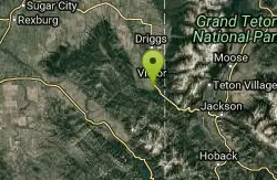
Teton Springs Trail
Victor, Idaho
2.1 miles S of Victor, IdahoTeton Springs Loop is a loop for cross-country skiing and snowshoeing. The loop is connected to the Teton Springs Resort, but is open to the public for free access. The trail starts on the South side of the Teton Springs Resort East Parking Lot.
The loop is 5.5 miles long with very little elevation change. It is a great place for beginners to practice snow shoeing and cross-country skiing. Teton Springs Loop loops around what during summer months is Teton Springs Golf Course.
The loop is frequented by many types of wildlife. Elk, moose and water fowls are frequently seen near the trail.
Teton Springs Loop is a wonderful trail for those in search of a wintertime adventure. It is easily accessible from the Rexburg and Idaho Falls Areas. This easy access makes this a wonderful way to connect with nature in the cold.
Trail Map: Teton_Springs_Map_2015.pdf
Grooming Report: http://tvtap.org/nordic-grooming

Kelly Mountain Trail
Ririe, Idaho
8.2 miles E of Ririe, IdahoKelly Canyon Trail is a moderate, uphill trail that can be used by hikers, mountain bikers, and ATV riders. The trail features views of hills, mountains, trees, wildflowers, and some wildlife. Dogs are allowed on the trail, but should be kept on a leash.
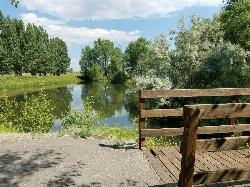
Rexburg Nature Park
Rexburg, Idaho
0.8 miles NW of Rexburg, IdahoRexburg Nature Park:
Life can be stressful, annoying, or just not good. Sometimes, it takes a moment to simply get away from the non-sense of this world; to gather yourself and seek peace and tranquility. That option is around the corner; you drive and see a trail, so you park and walk on the trail. As you walk, there's trees and sunlight shining on the leaves. You walk further and see a pond with ducks (both green and brown) and families sitting on the green grass with their kids; they watch, feed the ducks and take pictures with a smile on their face.
You go back to your vehicle and reminisce what you saw. Close to the south fork of the Teton River, is a nature park that isn't crowded with college students or infested with incoming traffic but a 15 acre park that was made so you can take your family or acquaintances for a picnic or a social gathering and enjoy; you also have the option to ride your bike or to jog on the trails.
The park is next to the Claire Boyle skate park, a beautiful golf course next to the fairgrounds and a 9 hole Frisbee golf course.
Features:
-Playground for the kids
-Fishing ponds ( A valid fishing license is required); fishing ponds for children as well.
-Wildlife and wildflowers
For more information and questions:
| Phone | 208-359-3020 Ext. 0 |
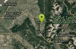
Driggs Nordic Trail
Driggs, Idaho
0.9 miles NE of Driggs, IdahoDistance: 3.1 miles (5km)
Trail Map: Driggs_Nordic_Track_2015.pdf
Grooming Report: http://tvtap.org/nordic-grooming

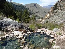
Mr. Bubbles Hot Spring
Old Faithful, Yellowstone National Park
24.0 miles SW of Old Faithful, Yellowstone National ParkMr. Bubbles is one of the few places you can actually soak in the thermal waters of Yellowstone National Park. The Bechler area of Yellowstone is one of the best kept secrets of the otherwise densely populated park. It's off the beaten path far from paved roads, boardwalks, tour busses and gift shops. In the backcountry, you'll walk singletrack dirt trails and see natural features not included on any brochure. There's also a good chance you'll see wildlife outside the safe comforts of your car door. Be aware of the animals around you (like bears, moose and bison). Give animals their space as to not threaten them.
You'll find the hot spring about halfway between the Bechler Ranger station and Old Faithful on the Bechler River Trail. (If you want to camp along the trail, you'll need to make a reservation with one of the parks backcountry offices)
This is a 15 mile hike to the attractions and another 15 to get out. Along the trail, you'll see several waterfalls and will have to cross the river multiple times. Some crossings are on logs while others are on bridges. Plan to get your feet wet. There is an impressive thermal feature near the hot springs.This is not the hot spring. This thermal feature is what pours into and heats up the small stream where you will soak in. Do not mistake this for the soaking pool you're looking for. The feature is dangerous because it will scald and can kill you. Mr. Bubbles will relax you. Don't mix them up!
CAUTION: WATER TEMPERATURES CHANGE AND ARE NOT ALWAYS SAFE. CHECK WITH THE RANGER STATION TO MAKE SURE IT'S SAFE BEFORE YOU PLAN YOUR TRIP.
CAUTION: NEVER HIKE AT NIGHT IN THE HOTSPOT AREAS OF YELLOWSTONE.. YOU WOULDN'T BE THE FIRST EXPERIENCED HIKER TO BE SCALDED TO DEATH IN AN UNEXPECTED THERMAL FEATURE.
Check https://www.nps.gov/yell/planyourvisit/swimming-soaking.htm for closures, regulations, and conditions.

Warm Slough Campground
Rexburg, Idaho
5.0 miles NW of Rexburg, IdahoThis is a pretty popular campsite that fills up pretty quick on busy weekends. Campsites are fairly spread out and there is no official donation box (as of July 2015). A couple of the campsites have picnic tables and there are several rock fire rings. There's also a restroom next to each boat ramp.
It's a popular put in and takeout spot on the river with two boat ramps, one on the creek and one on the river. There's also a pretty good spot to take out innertubes just under a mile downstream from the boatramp that's on the river, yet the boat ramp and takeout are only about 1000 feet away from each other which makes it really easy to do over and over again. There's another put-in further upstream that will almost double your float but also significantly increase your walk back. It's a pretty slow easy float and the water isn't super cold.
This used to be a popular spot for paintball which is now prohibited. Please take better care of the paintball fields we are permitted to use.

Ashton to Tetonia Trail
Ashton, Idaho
0.7 miles NE of Ashton, IdahoThe Idaho Department of Parks and Recreation undertook the project to transform the old Teton Valley Branch of the Union Pacific Railroad from Ashton to Tetonia into a trail for bikes, ATVs, and snowmobiles, runners, cross-country skiers, and horses. The trail goes from Ashton to Tetonia and can be accessed via Ashton, Marysville, Bitch Creek, Felt, or Tetonia. Information can be found at kiosks in Marysville and at Bitch Creek.
Elevation Gain (Southbound): 787 ft
Length: 29.6 mi
Goldbug (Elk Bend) Hot Springs
Salmon, Idaho
19.4 miles S of Salmon, IdahoGoldbug (Elk Bend) Hot Springs is a 4 mile out and back trail located near Salmon, Idaho that features rock laid hot springs up on the hill. The first little bit of the trail is private property that they're kind enough to allow guests on. Please be respectful of that privilege. The trail is often used through the winter as well and warmer months.

Webster's Dam
Ririe, Idaho
9.8 miles NE of Ririe, IdahoAlso known as Manmade Falls or the Woodmansee Dam, Webster Dam is an abandoned dam located deep in Moody Creek canyon, the dam was abandoned when sediment built up behind the dam which then caused the stream to split and flow around both sides of the dam, creating two beautiful waterfalls each about 15 feet in height. This makes a fun evening trip and is good for almost any time of the year as well. It's beautiful in the spring with powerful falls from the spring runoff and in the fall, there are plenty of fall colors along the pole line trail and around the waterfalls. At the falls, you'll find two waterfalls coming over each end of the dam. On the south end of the dam there is a bridge that spans the creek on that side. There is a little island in the middle where you can sit on the rock wall and take in the whole scene.
There are two trails which weave back and forth a couple of times so you can really choose your route a little bit. The main parking area is at the top of the hill by pole line and that's also the most common trailhead. The pole line trail follows the ATV road with several ups and downs. For the most part its a fairly rounded out and bermed double track awesome for mountain bikes and ATVs. For much of it, there's a hiking trail that follows along the side of it. However you travel this trail, be very aware of other riders and hikers which can seem to appear out of nowhere. The trail continues along the power pole lines for just over 3/4 miles, then turns left just as the balls on the power lines come into view. After a couple hundred feet, you'll see the other trail merge into this one from the left and then take off again to the right about 150 yards later. Keep left on the "pole line trail" for a more gradual decent or go right on the "wooded trail" for a more adventurous and much steeper route. The pole line trail go out and hook back taking you straight to the falls.
The wooded trail trailhead is Northwest of the pole line trail. It's a less used ATV track that goes back and forth between the woods and the pole line until it merges with the pole line trail about 3/4 miles in, only to split to the right 150 yards later. In another 100 yards, you'll come across another junction; keep left. In another 150 yards it will come back together with the pole line trail and continue all the way to the falls. On the upper portions, this trail is has a lot fewer ups and downs making it a more gradual hike. After merging with the pole line trail though, this trail becomes the much steeper option.
Whichever of these 2 paths you choose, the last 1/3 mile descent is more like a chunky forest road than the double track above. It has some pretty steep parts, some chunky rock sections, and some rollers that make great mountain bike jumps. While it's a little steep and chunky, most intermediate riders should be able to handle it just fine. At the bottom just before the falls are some very large dirt jumps off to the side. The last 30 yards to the falls after the dirt jumps is much more janky, probably more like a black diamond on a bike but not too tricky to get down on foot.
The third option is much longer, starting at the warming cabin on Brown's Road. It's an intermediate trail to the creek and then a green (easy) trail along the creek to the dam.
A very popular route to do this on a mountain bike is to loop it starting either at the warming cabin or the top of the pole line and riding down the pole line to the waterfall and then out Mad Cow and up Cabin Climb to complete the loop.
This can be a great family hike. Plan on 2-4 hours to hike it with little ones, depending on how fast and tough they are.
Palisades Hot springs
Swan Valley, Idaho
18.3 miles SE of Swan Valley, IdahoLegend has it... The hot water flows right into the lake. Feel free to dig your own little hot tub in the sand.

Palisades Creek Trail / Lakes and Waterfall Canyon
Irwin, Idaho
4.4 miles E of Irwin, IdahoPalisades Creek Trail is located about 50 miles southeast of Idaho Falls and about 60 miles west of Jackson Hole WY in Swan Valley Idaho. The four mile hike up to lower Palisades Lake or the 6.2 mile hike to Upper Palisades Lake (elevation 6800 feet) provide some of the best mountain views in the Swan Valley region. Palisades Creek Trail is well maintained and can be used only by hikers, backpackers or horses as it is in the Palisades Wilderness Study area. If you choose to hike up to Upper Palisades Lake, two miles above Lower Palisades Lake you have to leave Palisades Creek trail and turn up Waterfall Canyon Trail and it is just a short distance up Waterfall Canyon. The upper lake typically has better camping because sites at the lower lake fill up sooner.
Both lakes were formed ages ago when giant landslides came down the canyon and blocked the creek. If you scan the mountain walls you may see mountain goats. It is 4 miles to the lower end of the lower lake.
Trail Map courtesy of SnakeRiverMountainBikeClub.com

Table Rock / Table Mountain
Driggs, Idaho
10.0 miles E of Driggs, IdahoAt 11,300 feet, Table Mountain is possibly the most beautiful climb this side of the Tetons and offers what may well be the very best view of the Grand Tetons. It's just far enough away to be able to see all three peaks and close enough to make out all the detail.
There are 2 main trails with different distances but either way, you've got to climb over 4000 feet.
The Face trail is much steeper but also much shorter. It cuts out all of the switchbacks and 'B' lines it for the top. It's considerably shorter and you don't have to go very far before the view begins to open up and you can see the beauty of Teton Canyon and its surrounding peaks. (about 3.5 miles one way)
Huckleberry trail is much longer but also a much more gradual incline/decline. The trail follows and crosses North Fork Teton Creek making it a great spot to get a filtered water refill.It's not known as huckleberry for nothing. You just have to catch it at the right time (Mid-Late Summer depending on weather) and get to the bushes before everybody else picks them clean. (about 6.5 miles one way)
Check conditions via webcam at tetoncam.com.
Elevation: 11,300ft
Elevation Gain: 4000ft
Length: 7-13 miles

Fall Creek Falls
Swan Valley, Idaho
2.1 miles SW of Swan Valley, IdahoFalls Campground is located next to the Snake River near beautiful Swan Valley, only 45 miles east of Idaho Falls, Idaho. Mixed growth cottonwood trees provide partial shade, and grassy meadows with summer wildflowers dot the area. Wildlife is plentiful in the river bottom; eagles, osprey, moose, and deer are frequently spotted. Fall Creek Falls is about 1/4 mile from the campground. The Snake River offers excellent trout fishing, canoeing, rafting, and kayaking. Spring Creek and Conant Boat Ramps, open to the public, are nearby. Palisades Reservoir is less than 20 miles from Falls Campground, with great boating, waterskiing, canoeing, fishing, and swimming.

Sheep Falls on Henry's Fork
Island Park, Idaho
15.6 miles S of Island Park, IdahoSheep Falls cascades approximately 25' through a narrow basalt chute on the North Fork of the Snake River near Island Park, Idaho. Compared to nearby Lower and Upper Mesa Falls, that height may not sound particularly spectacular but it is a pleasant hike on a relatively well maintained trail and is rarely crowded.

Monkey Rock
Saint Anthony, Idaho
4.1 miles SE of Saint Anthony, IdahoMonkey Rock features a beautiful waterfall you can wade right up to during the summer. Just under the waterfall is a great spot to wade around in or even some shallow swimming pretty good for small children. Maybe you just want to take advantage of the great bank to bask in the summer sun. The water temperature is fairly cool, which by no means is unwelcomed during the hot summer months. You'll get used to the water fairly quickly once you're in. The waterfall is a fun feature at Monkey Rock, not to mention a popular engagement photo backdrop. The name "Monkey Rock" is derived from the "monkeys" who jump off the rocks at the top of the falls to the pool below. Though not a great height, it's important to be careful and only jump into areas clear of rocks and other hazards and where the water is deep enough that you won't hit bottom when you jump. There really isn't a safe spot to jump from the falls as it doesn't usually get more than 5 feet deep.
The real jumping location is off the Hog Hollow Bridge up the road from the waterfall.
PLEASE NOTE: On the roads leading to Monkey Rock, the speed limit is 35 mph for the last mile. There are kids, cows, horses, and dogs along that road and many people tend to speed going to and from Monkey Rock. Please slow down and stay safe.

Twin Bridges
St. Anthony, Idaho
6.6 miles NE of St. Anthony, IdahoThere's an old abandoned bridge next to the one currently in use. The water is pretty deep underneath and offers two distinct levels to jump from. There's a little rope swing under the bridge and a path up river that makes a great put-in spot for a LITTLE float. If you've got little kids, there's a great little sandbar on the north side of the bridge just upstream from all the commotion. There are almost always people there on the nice days but you rarely ever have to wait to jump.

Cress Creek Nature Trail
Rexburg, Idaho
11.9 miles S of Rexburg, IdahoMeandering along the scenic South Fork of the Snake River, the beautiful 1¼ mile Cress Creek Nature Trail will lead you on a journey through sagebrush-grass communities, over juniper covered slopes, and along a lush perennial creek. Cress Creek derives its name from the watercress plant, a favorite food of the moose that live in this area. With clear skies, prepare for an expansive view of the Snake River, volcanoes and farmland. The site offers ample parking, restrooms and trail accessibility, which attract a wide spectrum of trail users to the area. You will become familiar with life in the Cress Creek area as it is now and as it was long ago. If you hike quietly you may see deer, rabbits, small lizards, or possibly an eagle or a moose. The nature trail is self-guided with many beautiful interpretive signs posted along the way to assist you. The first half-mile of the trail is accessible by wheelchair.
On the northeastern corner of the trail, there's an overlook trail. Parts of it are pretty nice like the rest of the loop but some is barely recognizable as a trail. Parts of the trail are steep and parts of it go over some pretty loose rock. It goes for about a ½ mile all the way to the top of the hill. Just below the rim, there are several really cool caves. From the top, you can see from Rexburg to Idaho Falls.


