


Refine Search
- hike 74
- mountain bike 31
- camp 30
- swim 24
- backpack 14
- sled 12
- cave 12
- canoe 12
- cross-country ski 10
- kayak 9
- rock climb 8
- dive 7
- horseback 7
- disc golf 7
- airsoft 6
- paintball 5
- snowshoe 2
- hot springs 2
- skateboard 2
83 locations
Add Location
 Full Listing
Camp, Cave, Hike, Kayak, Swim
Last visited on 5 Oct 2018
Full Listing
Camp, Cave, Hike, Kayak, Swim
Last visited on 5 Oct 2018
0.3 mi
Full Listing
Rock Climb
Last visited on 16 Jun 2023
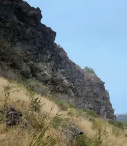
Pointless Crag
Ririe, Idaho
6.8 miles E of Ririe, IdahoCourtesy of Dean Lords, Route Setter deanlords.blogspot.com
- NO MORE BOLTING as of 5/2012 requested by the Bureau of Land Management.
- The BLM has asked us NOT to park on the road below the cliff. Please use the obvious parking area next to the river before reaching the cliff. The parking area is 2.7 miles up the South Fork Rd on the right from where you turn off of the Ski Hill Road.
- Some of the 1st bolts are high off the ground and require climbing through suspect rock to clip. PLEASE don't trust the stone and protect yourself by clipping the first bolt from the ground with a stick clip.
- Many top anchors are equipped with carabiners for convenience and safety with these short routes. They are not yours to take home! Use them for lowering only. If you are going to top-rope or run lead laps, please use your own quickdraws at the anchors until the last lap, then lower off the fixed biners.
- The rock on most routes is suspect and the climber is not responsible for maintaining awareness of all persons on the ground. If you get whacked by falling rock, it's your own fault. Belay, cheer, observe, socialize in a safe place. Take it seriously and speak up if you see someone in harms way. The climber isn't looking out for your safety... you are. Take it seriously. Serious.
- Rattlesnakes, ticks, and mosquito's. Nothing more needs to be said.
Routes from Left to Right
| Route | Difficulty |
| Black Betty | 5.12b |
| 50 yard gap | |
|---|---|
| Head on a Silver Platypus | 5.10a |
| Sleepwalker | 5.10d |
| 4-Alarm Fire | 5.10b |
| Hoppe Hill | 5.10c |
| Hustle and Flow | 5.12d |
| Goat Meal | 5.11a |
| Hungry Eyes | 5.9 |
| Stingray | 5.10c/d |
| 30 yard gap | |
| Orbit | 5.11a |
| 20 yard gap | |
| Rock-in My Sports Bra | 5.9 |
| Disappearing Hat Trick | 5.10a |
| Lords-a-Leaping (AKA 5.7 Crack) | 5.7 |
| Black Bear | 5.12a |
| What's the Point? | 5.11b |
| 11 O'clock | 5.10a |
| Team Trailer | 5.8 |
| The Bicycle Thief | 5.10a |
| Alien Pod | 5.7 |
The routes are marked on the map but are not the exact GPS. They are in the right order and should get you fairly close to the right routes.
0.9 mi
 Full Listing
Camp, Canoe, Kayak, Swim
Last visited on 11 Jul 2020
Full Listing
Camp, Canoe, Kayak, Swim
Last visited on 11 Jul 2020
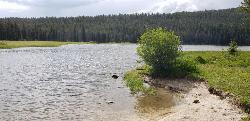
Buffalo River Campground
Island Park, Idaho
0.5 miles NE of Island Park, IdahoThe float here is nice and easy. It's a great early season float. Later in the season the shallow spots will force you to walk a good chunk of the float. The water is super clear and often pretty warm (for a river). The current is often slow enough you can float down in your canoe or kayak and then paddle back up.
Buffalo Campground is located 26 miles south of West Yellowstone, Montana in beautiful Island Park, Idaho along the banks of the Buffalo River at an elevation of 6,200 feet. A mixed growth pine forest provides partial shade; aspens dot the landscape, and summer wildflowers are abundant. The Buffalo River has good brook and rainbow trout fishing. Wildlife can be frequently spotted throughout the area. Buffalo Campground boasts 117 single units, 4 double units, and 1 group site. It has some power hook-ups and is a good fishing spot.Courtesy of fs.usda.gov
17.5 mi
 Full Listing
Camp, Canoe, Hike, Kayak, Mountain Bike, Swim
Last visited on 27 Jun 2020
Full Listing
Camp, Canoe, Hike, Kayak, Mountain Bike, Swim
Last visited on 27 Jun 2020
Tear Drop Lake
Ashton, Idaho
19.1 miles NE of Ashton, IdahoNestled in the Targhee National Forest just off of Ashton's Fish Creek Road, this tear drop shaped lake is a family adventure waiting to happen. The lake isn't very big but it is teeming with life. Early in the morning the lake is so beautiful and calm that you can hear the fish jumping from across the water. Take your kayak out early and you can see well into the crystal waters. You could also take a hike or bike ride on the trail that circles the lake. It's got enough ups, downs, and turns to keep it interesting but is easy enough that even the most novice bikers can do it with ease.
As it warms up a little, the kayaks take over and it becomes a playground for family fun. The lake is big enough for there to be plenty of room for everyone but small enough that you can feel safe with some of your younger ones out in the middle of a lake fighting to tip each others' kayaks over. The shores are great for wading and swimming. There have been rope swings and diving boards at times but there is a sign there prohibiting any such devices of mass fun and liability.
As the sun fades, everybody slowly retreats to their camps, the lake quiets down again, and fisherman have their time. If you haven't yet, now is the time to soak yourself in all your bug spray and get out your citronella torches. Yes, even the mosquitos are impressive here.
The campsites here are primitive providing at most a place to park, a flat spot for your tent, and maybe a fire ring made of rocks. There are somewhere around 10 such spots on the East and West ends of the lake. There are no bathrooms, water pumps, or garbage cans here so come prepared with your own drinking water and the ability to properly dispose of your own waste. This is bear country so take care with your food and make sure you have a good way to store it overnight.
This is one of those great free spots that hasn't been overrun with people or regulations yet. Please help to keep it that way by being considerate and following the principles of leave no trace.
0.5-3.5 mi
 Full Listing
Camp, Hike, Mountain Bike
Last visited on 25 May 2020
Full Listing
Camp, Hike, Mountain Bike
Last visited on 25 May 2020
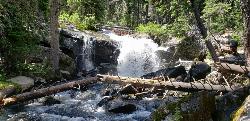
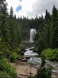
Webster's Dam
Ririe, Idaho
9.8 miles NE of Ririe, IdahoAlso known as Manmade Falls or the Woodmansee Dam, Webster Dam is an abandoned dam located deep in Moody Creek canyon, the dam was abandoned when sediment built up behind the dam which then caused the stream to split and flow around both sides of the dam, creating two beautiful waterfalls each about 15 feet in height. This makes a fun evening trip and is good for almost any time of the year as well. It's beautiful in the spring with powerful falls from the spring runoff and in the fall, there are plenty of fall colors along the pole line trail and around the waterfalls. At the falls, you'll find two waterfalls coming over each end of the dam. On the south end of the dam there is a bridge that spans the creek on that side. There is a little island in the middle where you can sit on the rock wall and take in the whole scene.
There are two trails which weave back and forth a couple of times so you can really choose your route a little bit. The main parking area is at the top of the hill by pole line and that's also the most common trailhead. The pole line trail follows the ATV road with several ups and downs. For the most part its a fairly rounded out and bermed double track awesome for mountain bikes and ATVs. For much of it, there's a hiking trail that follows along the side of it. However you travel this trail, be very aware of other riders and hikers which can seem to appear out of nowhere. The trail continues along the power pole lines for just over 3/4 miles, then turns left just as the balls on the power lines come into view. After a couple hundred feet, you'll see the other trail merge into this one from the left and then take off again to the right about 150 yards later. Keep left on the "pole line trail" for a more gradual decent or go right on the "wooded trail" for a more adventurous and much steeper route. The pole line trail go out and hook back taking you straight to the falls.
The wooded trail trailhead is Northwest of the pole line trail. It's a less used ATV track that goes back and forth between the woods and the pole line until it merges with the pole line trail about 3/4 miles in, only to split to the right 150 yards later. In another 100 yards, you'll come across another junction; keep left. In another 150 yards it will come back together with the pole line trail and continue all the way to the falls. On the upper portions, this trail is has a lot fewer ups and downs making it a more gradual hike. After merging with the pole line trail though, this trail becomes the much steeper option.
Whichever of these 2 paths you choose, the last 1/3 mile descent is more like a chunky forest road than the double track above. It has some pretty steep parts, some chunky rock sections, and some rollers that make great mountain bike jumps. While it's a little steep and chunky, most intermediate riders should be able to handle it just fine. At the bottom just before the falls are some very large dirt jumps off to the side. The last 30 yards to the falls after the dirt jumps is much more janky, probably more like a black diamond on a bike but not too tricky to get down on foot.
The third option is much longer, starting at the warming cabin on Brown's Road. It's an intermediate trail to the creek and then a green (easy) trail along the creek to the dam.
A very popular route to do this on a mountain bike is to loop it starting either at the warming cabin or the top of the pole line and riding down the pole line to the waterfall and then out Mad Cow and up Cabin Climb to complete the loop.
This can be a great family hike. Plan on 2-4 hours to hike it with little ones, depending on how fast and tough they are.
3.8 mi
 Full Listing
Hike, Mountain Bike
Last visited on 11 Oct 2019
Full Listing
Hike, Mountain Bike
Last visited on 11 Oct 2019
Stinking Springs
Ririe, Idaho
6.5 miles E of Ririe, IdahoStinking Springs is a great early to late season trail. Being at the edge of the Big Hole range, it gets spring earlier and winter later than other trails in the range. It's closed from December through April to accommodate wintering mule deer but is often very accessible up until it's closed and as soon as its open.The trail begins at the Stinking Springs Multiple Use Area parking lot on East Heise Road to the right (South) of the Sidewinder trailhead. You'll be looking for the gate with a cattle guard. The small spring gate will take you to Sidewinder, a MTB specific trail.
The trail starts out pretty straight and gradual but as you get higher up, there are more and more switchbacks that get more and more bermed as you get higher up. At the upper end, you'll find well bermed corners, rock rolls, and rock gardens great for more experienced mountain bikes. The once beautifully laid rock corners have broken down somewhat making them more of a chunky ride than they were originally though. If you continue up the trail, you can connect into the trails at Kelly Canyon and throughout the Bighole range.
Although this is primarily an ATV and dirt bike trail, Stinking Springs is the unsung hero of mountain biking with its brother Sidewinder. Most bikers take Sidewinder up and down or use Stinking Springs as a climbing trail to access Sidewinder. However, coming down Stinking Springs has a little bit of a Wolverine Canyon feel to it with wide track, beautiful berms and floating jumps. It's not as rollie as those Space Cruz trails and has far fewer switchbacks but is a fast roll with a lot of fun.
3.6 mi
 Full Listing
Canoe, Hike, Kayak, Swim
Last visited on 3 Aug 2019
Full Listing
Canoe, Hike, Kayak, Swim
Last visited on 3 Aug 2019
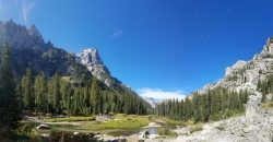
String Lake
Alta, Wyoming
16.4 miles NE of Alta, WyomingString Lake is a shallow lake that connects Leigh Lake and Jenny Lake at the base of Mount St. John and Rockchuck Peak. From the lakeshore, you can also take in beautiful views of Teewinot and Mt. Moran. The shallow lake is much colder than the glacier lakes on either side. The warm water makes it great for a swim and there's a lot of great areas for kids to wade in. Got a Kayak or Canoe, you'll love how clear the water is as you'll be able to see the bottom anywhere on the lake. It's also a great way to access Leigh Lake and Jenny Lake to do some boating on more open waters. You can put in at String Lake, boat to an end, and then portage to the connecting lake at a much less congested part of the lake.
Rather go for a hike? The String Lake Trail loops around the lake and far enough up the hill that you can get great views of String Lake. Come a little later in the summer and enjoy wild berries along the Northern half of the loop. Stay away from anything that's bright red though. If you're looking for something bigger, the String Lake Trail connects into trails into Paintbrush Canyon, Jenny Lake, and Leigh Lake. The Leigh Lake connection is right at the north end of the lake on the East side of the bridge. From there it's 0.1 miles to the Leigh Lake portage and you will be doing yourself a huge disservice if for some reason you decide not to take this detour. At that point on Leigh Lake, you'll find a tiny little sandbar with lots of rocks sticking up out of the water for hopping around and some amazing views. The portage is only a couple hundred feet away from Boulder Island which beautifully frames the view of Mt. Moran towering over the peaceful lake.
0.6 mi
Pintler Falls
Wise River, Montana
23.8 miles W of Wise River, MontanaHike near Wise River, Montana
Full Listing
Hike
Last visited on 6 Jul 2019
Pintler Lake Campground and Picnic Area
Wise River, Montana
23.4 miles W of Wise River, MontanaCamp, Canoe, Kayak, and Swim near Wise River, Montana
Full Listing
Camp, Canoe, Kayak, Swim
Last visited on 5 Jul 2019
6.6 mi
 Full Listing
Hike, Swim
Last visited on 3 Jul 2019
Full Listing
Hike, Swim
Last visited on 3 Jul 2019
Devil's Bathtub
Duffield, Virginia
10.4 miles NE of Duffield, VirginiaThe Devil's Fork Loop Trail is a difficult hike that has become popular because of it's unique water features. The trail is 7.2 rocky miles with several steep areas. Along the hike there are several places where visitors can enter Devil's Fork's extremely cold waters. These swimming holes are all small and deep with crystal clear water.
About two miles into Devil's Fork Loop Trail hikers will reach the most famous swimming hole of the hike, the Devil's Bathtub. The Devils Bathtub is a deep clear pool beneath a waterfall surrounded by steep rippled cliffs. The pool is only a few feet wide and is very deep. The water here is bubbling from the waterfall and freezing cold. Swimmers enter the water at their own risk and should exercise caution while doing so.
The parking lot for Devil's Fork Loop Trail is about half a mile from the trail itself. Hikers should be prepared with enough water and food for a long difficult hike.
Fall Creek Falls
Swan Valley, Idaho
2.1 miles SW of Swan Valley, IdahoFalls Campground is located next to the Snake River near beautiful Swan Valley, only 45 miles east of Idaho Falls, Idaho. Mixed growth cottonwood trees provide partial shade, and grassy meadows with summer wildflowers dot the area. Wildlife is plentiful in the river bottom; eagles, osprey, moose, and deer are frequently spotted. Fall Creek Falls is about 1/4 mile from the campground. The Snake River offers excellent trout fishing, canoeing, rafting, and kayaking. Spring Creek and Conant Boat Ramps, open to the public, are nearby. Palisades Reservoir is less than 20 miles from Falls Campground, with great boating, waterskiing, canoeing, fishing, and swimming.
15.0-18.4 mi
 Full Listing
Backpack, Hike, Horseback
Last visited on 15 Sep 2018
Full Listing
Backpack, Hike, Horseback
Last visited on 15 Sep 2018
Alaska Basin
Driggs, Idaho
10.0 miles E of Driggs, IdahoThe Alaska Basin Trail is a stunning trail through the Jedediah Wilderness near Driggs, Idaho and goes East into Wyoming, just outside of Grand Teton National Park. The trail is wide and has easy terrain for the feet, but it is long, so it's best suited for intermediate to advanced hikers. There are spots on the trail where river crossing is necessary, so be prepared to rock hop, cross logs, or just get your feet wet.
Because the trail is in a wilderness area, rather than a National Park, no overnight camping permits are required; however, open fires are not allowed, so plan on bringing a camping stove. Carry bear spray and, if you are camping, plan on bear proofing your food and waste.
The trail features a variety of landscapes such as lush vegetation and wildflowers (peak season is July to August), rushing rivers and streams, the majestic Teton Mountain Range, and of course, the serene Alaska Basin. There is plenty of wildlife; black bears and moose both have been spotted on the trail. Enjoy their beauty, but please use precaution and respect their territory.
24.3 mi
 Full Listing
Backpack, Hike
Last visited on 15 Sep 2018
Full Listing
Backpack, Hike
Last visited on 15 Sep 2018
Cascade Canyon Trail
Jackson Hole, Wyoming
18.9 miles N of Jackson Hole, WyomingThis hike starts the same as the Jenny Lake trail, then after you pass the boat dock, it takes off up Cascade Canyon just to the north of Teewinot, Mount Owen, and the Grand Teton along Cascade Creek. You'll notice a significant drop in trail traffic as soon as you pass the Hidden Falls area. At any time of year, it will be clear why it's called Cascade Canyon. After only a few miles in, you'll start to see waterfalls cascading down the sides of the mountains as they melt off the glaciers. If you make it a little earlier in the season, you'll see even more falls and bigger cascades.
Watch for wildlife. You're likely to see bear, moose, elk, deer, and marmots along this route.
Key Distances:
- Hidden Falls - 2.5 mi
- Cascade Canyon Trail - 3.0 mi
- South Fork Campground - 6.8 mi
- Schoolroom Glacier - 11.5 mi
- Hurricane Pass - 12 mi
3.2-47.0 mi
 Full Listing
Backpack, Cross-country Ski, Hike, Horseback, Mountain Bike
Last visited on 1 Sep 2018
Full Listing
Backpack, Cross-country Ski, Hike, Horseback, Mountain Bike
Last visited on 1 Sep 2018
Yellowstone Branch Line Trail
Ashton, Idaho
7.6 miles NE of Ashton, IdahoYellowstone branch line trail runs from Warm River to the Montana border totaling 39 miles. There are a few places to jump on and off the trail as well as a few smaller trails that branch off of this larger trail. A lot of the traffic covers small portions of this trail so not many people tackle the trail in its entirety. The trail offers a variety of different activities. It is open for backpacking, hiking, mountain biking, horseback riding, and all terrain vehicles under a certain size. Depending on what you want to spend your day doing it’s a good idea to plan accordingly.
Also known as The Great Western Trail of Idaho, The Warm River Rail Trail, Route of the Yellowstone Special, or the northern portion of the Yellowstone Grand Teton Rail Trail.
1.7 mi
 Full Listing
Mountain Bike
Last visited on 21 Aug 2018
Full Listing
Mountain Bike
Last visited on 21 Aug 2018
Randy's Cow Trail / Ken's Corner
Ririe, Idaho
7.5 miles E of Ririe, IdahoThis trail descends from the fence corner at the West end of Batman and continues down to Lyon's Creek Parking just off Lyon's road. The top of this trail is only a couple hundred yards from Buckskin Morgan making it a great connection with Batman or Buckskin Morgan. If you want to connect it, you'll have to hop a fence at the corner or go through a gate just a little further up the trail from the corner. The fence separates the National Forest from State land. If you do go through the gate, please be courteous and close the gate properly to keep any livestock on the right side of the fence.
The trail itself is gradual and windy. It's perfect for a nice leisurely ride, going up or down, or if you add just a little bit of speed it becomes an exhilarating ride with great tight corners.If you're familiar with Buckskin, this trail is like a tighter version of that without the rock. The canopy is in pretty tight and full on most of this one and if you go in the early morning, the smells of the forest are incredible.
Towards the bottom, you'll find one more gate that you'll need to go through. Make sure to close it back properly. From there, you ride an old forest road out to the parking area, with all the speed, ruts, and bumps that you'd expect. The ease of the climb coupled with the gradual downhill make this a great ride for beginners and the tightness makes it a great ride for any other level. Simply put, this is a fun trail.
1.6-14.1 mi
 Full Listing
Camp, Hike, Horseback, Swim
Last visited on 18 Aug 2018
Full Listing
Camp, Hike, Horseback, Swim
Last visited on 18 Aug 2018
Mount Timpanogas
Provo, Utah
13.7 miles N of Provo, UtahMt. Timp, as the locals call it, is the 2nd highest mountain in the Wasatch range (only Mt. Nebo is higher). What sets "Timp" apart is its location. It towers over the Provo, Orem, Pleasant Grove area and its a very dominant feature. It rises 7000 feet from the valley floor and draws your gaze to it again and again.This mountain may be the most popular one in the state of Utah and is certainly the most climbed. Mt. Timpanogos is a huge mountain, extending almost seven miles in a north to south direction with many of its peaks reaching over the 11000 foot mark.
7.6 mi
 Full Listing
Hike
Last visited on 7 Jul 2018
Full Listing
Hike
Last visited on 7 Jul 2018
Mount Jefferson
Island Park, Idaho
9.7 miles N of Island Park, IdahoMount Jefferson, at 10, 203 feet is the highest point in the Centennial Mountains, a small, local range on the border of Idaho and Montana a little west of Yellowstone. These mountains consist of a long ridge line the forms the Continental Divide between the headwaters of the Snake River and Jefferson River, which is primary headwater stream of the Missouri River. The summit area is composed of two primary ridge points with a lower point in between and a high ridge point to the east. The west ridge point is 10,161 feet, the smaller central point is approximately 10,140 feet and the separated eastern point is about 9,800 feet. Courtesy of summitpost.org
1.4-4.6 mi
 Full Listing
Hike
Last visited on 26 Jun 2018
Full Listing
Hike
Last visited on 26 Jun 2018
St Mary and Virginia Falls
Rising Sun, Glacier National Park
4.4 miles W of Rising Sun, Glacier National ParkVirginia Falls is one of two major waterfalls that feed into St Mary Lake. The trail is about 3.7 miles roundtrip, where visitors will see other waterfalls such as St Mary waterfall. The trail begins at the St Mary Falls trailhead on Going-to-the-Sun road, where there is a parking lot. Becasue there are multiple waterfalls in the area, this parking lot can get full very quickly, so it might be best to head out early in the morning or take a shuttle from Many Glacier.
An easy and scenic trail, visitors will go through the forest and past streams. St Mary Falls is a two tiered waterfall with a drop of over 50 ft. If tired, there are some nice spots to sit and catch a break, as well this point can make a good turn around point.
Virginia Falls is the next waterfall hikers will see. There is an upper portion of the falls and a lower portion. Both are beautiful to see. Like most waterfalls, the best time to see them is early in the season when the snowmelt is beginning and water is tumbling over the falls.
4.5 mi
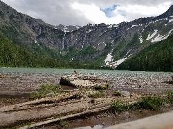
Avalanche Lake
Apgar Village, Glacier National Park
13.1 miles NE of Apgar Village, Glacier National ParkHike near Apgar Village, Glacier National Park
Full Listing
Hike
Last visited on 25 Jun 2018
0.9 mi
 Full Listing
Hike
Last visited on 24 Jun 2018
Full Listing
Hike
Last visited on 24 Jun 2018
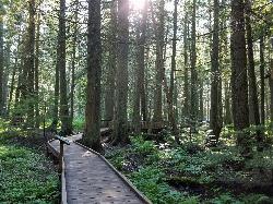
Trail of the Cedars
Apgar Village, Glacier National Park
13.2 miles NE of Apgar Village, Glacier National ParkThe Trail of the Cedars is one of the most popular hikes in the park because of it offers great views without too much exertion. It is a short loop hike around Avalanche Creek in Glacier National Park. The hike is a fairly easy walk through a cedar tree forest and offers gorgeous views of Avalanche Creek which now cascades downstream as glacially melted water. The trees in this forest are some of the tallest and the oldest in the park, reaching up to 100 feet tall and 4 to 7 feet across at around 500 years old. This area has survived fires and avalanches for years, allowing it to flourish. The trail is wheelchair accessible and leads to a footbridge at the creek.
Just past the Avalanche Lake trail junction is an even closer view of the creek and the trailhead to Avalanche Lake, which is another 1.6 miles for those feeling a little more adventurous.
After passing Avalanche Creek, the trail reaches past the Avalanche Creek Campground and loops back out to the road. Parking can get difficult here because it is such a popular hike and there are limited spaces. The trailhead is about 5 and a half miles from Lake McDonald Lodge, along Going to the Sun Road.
1.7 mi
 Full Listing
Hike, Mountain Bike
Last visited on 17 May 2018
Full Listing
Hike, Mountain Bike
Last visited on 17 May 2018
Buckskin Morgan Ridge
Ririe, Idaho
9.0 miles E of Ririe, IdahoGoing up is a little tough because of the rocks, but once you clear the top it is a twisty down hill portion [until] you get to a fenced road. From there you can turn around or keep going strait and follow the snowshoe trail back to an unkempt road [which] will lead back down to the main Kelly canyon road. If that is the case hang a right when you get to the main road and pedal up hill till you get to the parking area. I recommend gong back down the hill to get some really bumpy DH though ***watch for roots and rocks if you go back to the parking area via the morgan trail**** Courtesy of Singletracks.com
Climb from the Hawley/Buckskin parking area to the top of Buckskin Morgan Ridge. The trail has several steep climbs before getting to a rolling hill section that leads you to a dirt road. The trail starts from Road 218, heads into the trees and then up the hill. There is a sign on your right as you start your first climb. You'll encounter plenty of roots on the first climb. Shortly after that, the trail will again have another climb as you head north and west. The second climb is marked by plenty of loose rocks. Once on top of this section, you'll weave your way through the trees and down the hill to an intersection with the road. Courtesy of MTBProject.com
×


