


38.2K 1 by endovereric
first prev 1 next last
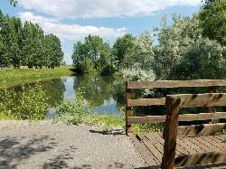
Lorenzo Bridge
Rexburg, Idaho
7.2 miles SW of Rexburg, IdahoThis is the old site of the Lorenzo Boat Launch, which has moved to the other side of the river a little further downstream. This spot sees very little traffic. There are beautiful, yet primitive trails along the river and a well hidden lake. There is a lot of marsh ground and the falls colors are amazing. The trails drawn on the map here are partial. They can be followed further and likely connect to form a loop. If you know the rest of the trail, please let us know.
Paintball Field
Great natural boundaries; There's a river on one side and a dry bed on the other. On one end, it drops down and then becomes sparse. On the other end, there's a fence with nice walk-in gates. There's a dry creek bed that runs through it to one side that gives it a good amount of variety. There's quite a bit of undergrowth and even a couple of nice big man-made stick barriers toward the middle of the field.
When the construction started on the Thornton exit, they blocked off the parking lot on the West side. They built a new parking lot on the East side across the tracks and a trail underneath the bridge and road. You have to haul your stuff now but there is still access to an awesome field.

Hidden Vista / Pine Loop
Ririe, Idaho
9.0 miles E of Ririe, IdahoYou'll find the Hidden Vista trailhead on the South End of the Buckskin Morgan parking lot about a mile past Y Junction. This is a short trail with a little up and a little down for just under a 1/2 mile to the Hidden Vista where the trail opens up to the canyon and all the way out to the Snake River. The view isn't what you'd have at the top of a peak but is nonetheless and beautiful view. From there, you can go back the way you came or take a detour off to the right (East) on your way back and get a little downhill action. There's pretty good little climbs, turns, rocks, and even some fun jumps at the bottom. When you're done playing on the jumps, it's just a short climb back up to the parking lot or to the trailhead so you can do it again. The trail is primary singletrack, is fairly well maintained, and is shared by hikers and mountain bikers.

Eagle Park
Rexburg, Idaho
0.9 miles N of Rexburg, IdahoEagle Park is a little urban oasis. Once you drive in to this cottonwood forest along the river, you may forget that you're still inside Rexburg city limits. You can camp, picnic, throw rocks in the river, fish, mountain bike, or just go for a walk along the trail or road. All sites have picnic tables, fire rings, and tent pads. Just off the main parking lot is a nicely mowed grassy area that is a popular dog park. On the West end of the parking lot, you'll find a multi-use trail that will take you almost the entire length of the park.
Mountain Biking/Hiking/Walking
The trail system at Eagle Park is maintained in part by Free Arenas. If you have any would like to get involved or just want to share your thoughts on how to improve it, email [email protected].
Tenderfoot is primarily a mountain bike trail. The trail runs back behind most of the campsites. While it's built for mountain bikes, it's usually great for a nice quiet walk as well, and arguably the best way to see the park. This 0.5 mile trail is rated Easy but is about as tough as an easy trail can get. It's pretty mellow but does have a couple of quick punchy climbs and a non-optional berm climb over a large tree branch.
Taut-line is cut into the slope along the fence line. It begins on the embankment at the West end of the campground and goes for 0.4 miles. The Northwest section is the longest section of trail in Eagle Park and is cut into a steep slope above marsh and ponds. It is generally downhill from the West end but has plenty of up and down. Towards the middle of the trail, there is a berm and table top. The section South of the Tenderfoot junction was an Eagle Project completed by Ian Hoffman and his volunteer crew. The trail continues to cut up and down the side hill with a fun rock berm and a rock garden. The end drops in to connect back to Tenderfoot right near the junction with Bugler. The trail has short climbs and fun drops going southward so going the other way, you get punchy climbs and longer descents. Because it's much higher than the Tenderfoot Trail it parallels, Taut-line does not flood and actually bypasses the worst flood area of Tenderfoot. The bench cuts are on the narrower side. Because the trail does go along a steep slope, remember to fall uphill. This trail is rated Intermediate.
Bugler drops off the Tenderfoot Trail and runs down and around a pond just off the lawn. There's a few drops, climbs, and berms adding a little bit of speed and a little more difficulty.
Jamboree drops off the Eagle Park Road near campsite 19 and continues down along the river to the old campsite 14 that's now a disc golf basket. This trail rolls back and forth through a trough of sorts with some jumps along the edges and potential for many more. It seeps ground water when the water is higher and is completely flooded in May/June when the river is really high. When it's dry though, it rides decently fast and is a lot of fun!
Skills Park Along the Tenderfoot Trail and just off the lawn is a skills park built as an Eagle Scout project by Erik Hurst and other volunteers. It features a large wrap-around berm on the north end, raised skinnies made of 2x8 2x6 and 2x4 treated lumber, a ladder a-frame, a rock garden, and a see-saw.
While not all trails are intended to bi-directional and multi-use, they are all used as such so please be aware of others on the trail.
Looking for a little longer hike or ride? Go to the Northwest end of the park and you'll find an old raised road that follows the airport fence line to the Nature Park. It's pretty popular to loop both parks together.
Sledding
New in 2018, there's a sledding hill area just off the main grassy area. It's a terraced hill with a couple set runs and then quite a bit of open hill as well. Elevation is only about 20 feet from top to bottom but there's plenty to keep kids busy for awhile. There's even a more difficult run that includes jumps and drops for snowboards. The terrace trails are better when the snow's a little bit icier but the small hills are great for little kids that wnat to avoid the more popular hill at Smith Park
Camping
Picnicking is free but there is a fee for camping. Overnight camping fee is $10.00 per space paid via rexburg.org. All fees are used for future picnic tables, restrooms and other park improvements. The camp fee for boy scout troops may be waived as long as they perform an approved 1 hour service project to the park while camped here. Picking up garbage and pulling weeds are always approved. Weeds that need pulled include hounds tongue, cocklebur, bull thistle, and the occasional stinging nettle.
Posted Eagle Park Rules
- No RVs in park
- No motorcycles, scooters, or ATVs on park roads
- 7 day camping limit
- Tents only on designated tenting pads
- Fires in designated fire pits only. No non-burnable items in firepits.
- No smoking, tobacco, or alcoholic beverages
- Pets on leashes only. (All pet droppings to be put in bags for droppings)
- All garbage to be put in garbage cans. Pack it in - Pack it out.
- No firearms, firecrackers, or explosives
- Avoid loud music and noises — Be respectful of other campers
To reserve an entire shelter, call City Hall at 359-3020. Reservation fee is $25 per half day.
This is a community service project of Free Arenas, the Madison Lions Club, Trails of Madison County, the City of Rexburg, and numerous Eagle Scouts in the Yellowstone District of the Grand Teton Council, BSA. Constructed 2001-2005.
Please respect the flora and fauna and practice the Outdoor Code. This park only exists because of volunteer service from many in the community. Please, don't be afraid to help out by collecting some hounds tongue, cocklebur, and bull thistle. If you're looking for ideas for a bigger service project, contact [email protected]
Rexburg Nature Park
Rexburg, Idaho
0.8 miles NW of Rexburg, IdahoRexburg Nature Park:
Life can be stressful, annoying, or just not good. Sometimes, it takes a moment to simply get away from the non-sense of this world; to gather yourself and seek peace and tranquility. That option is around the corner; you drive and see a trail, so you park and walk on the trail. As you walk, there's trees and sunlight shining on the leaves. You walk further and see a pond with ducks (both green and brown) and families sitting on the green grass with their kids; they watch, feed the ducks and take pictures with a smile on their face.
You go back to your vehicle and reminisce what you saw. Close to the south fork of the Teton River, is a nature park that isn't crowded with college students or infested with incoming traffic but a 15 acre park that was made so you can take your family or acquaintances for a picnic or a social gathering and enjoy; you also have the option to ride your bike or to jog on the trails.
The park is next to the Claire Boyle skate park, a beautiful golf course next to the fairgrounds and a 9 hole Frisbee golf course.
Features:
-Playground for the kids
-Fishing ponds ( A valid fishing license is required); fishing ponds for children as well.
-Wildlife and wildflowers
For more information and questions:
| Phone | 208-359-3020 Ext. 0 |

Aspen Trail
Alta, Wyoming
2.3 miles S of Alta, WyomingAspen Trail (tr 034) is single track trail for 4.35 miles along 6,800 ft contour to Darby Canyon (tr 012). Spring Creek Trail (tr 032) is double track trail for 3.68 miles to end.
The trail starts up a doubletrack heading east out of the parking lot. 1/4 mile in, take the fork to the right. It's singletrack from here to the other end at Darby Canyon. Some sections are smooth and fast, others are rocky and boulder strewn. Probably not a trail for a first timer, but any intermediate can do it. It can be done as an out and back to Darby Canyon, or you can go west out of the Canyon to Stateline road, and take the road back to where you started. Courtesy of Singletracks.com

Harriman State Park
Island Park, Idaho
8.3 miles SW of Island Park, IdahoHarriman State Park is found 38 miles from Yellowstone along Henry's Fork. This 11,000-acre wildlife refuge is open year round for most activities. In addition to having beautiful scenery and wildlife, the area also has several houses that were built when the park was a privately owned ranch. The area is home to one of the best fly-fishing streams in the country, an eight mile portion of Henry's Fork river. There are many activities here including horseback riding, hiking, tours of the ranch, and fly-fishing.
During the summer, the trails through Harriman are a great place to hike and explore. There are plenty of wildflowers growing and the lakes and rivers flow nicely. Visitors will be able to see plenty of small wildlife, including swans on Silver lake, and there might even be a chance to see a moose or a bear. Part of the park crosses into the Caribou-Targhee National Forest. Along the river, there are beautiful views of the Tetons and the Yellowstone Plateau.
In the winter, the park is home to more than 24 miles of Nordic ski trails. The trails all vary in level of difficulty and distance. Most of the trails will go around Silver Lake and loop back towards the ranch houses. Other winter activites include fat biking and snowshoeing. The ranch houses are great in the winter because several have large fireplaces to warm up by.
The ranch houses can be rented out by visitors and have different accommodations for each house. Some of the houses include large gathering areas great for large groups of people. During different seasonns of the year the park offers events for the general public including star gazing and music camps.
This is an Idaho State Park and there are day use fees. Passes have reciprocity with Mesa Falls State Park which is only about 20 minutes away.

Webster's Dam
Ririe, Idaho
9.8 miles NE of Ririe, IdahoAlso known as Manmade Falls or the Woodmansee Dam, Webster Dam is an abandoned dam located deep in Moody Creek canyon, the dam was abandoned when sediment built up behind the dam which then caused the stream to split and flow around both sides of the dam, creating two beautiful waterfalls each about 15 feet in height. This makes a fun evening trip and is good for almost any time of the year as well. It's beautiful in the spring with powerful falls from the spring runoff and in the fall, there are plenty of fall colors along the pole line trail and around the waterfalls. At the falls, you'll find two waterfalls coming over each end of the dam. On the south end of the dam there is a bridge that spans the creek on that side. There is a little island in the middle where you can sit on the rock wall and take in the whole scene.
There are two trails which weave back and forth a couple of times so you can really choose your route a little bit. The main parking area is at the top of the hill by pole line and that's also the most common trailhead. The pole line trail follows the ATV road with several ups and downs. For the most part its a fairly rounded out and bermed double track awesome for mountain bikes and ATVs. For much of it, there's a hiking trail that follows along the side of it. However you travel this trail, be very aware of other riders and hikers which can seem to appear out of nowhere. The trail continues along the power pole lines for just over 3/4 miles, then turns left just as the balls on the power lines come into view. After a couple hundred feet, you'll see the other trail merge into this one from the left and then take off again to the right about 150 yards later. Keep left on the "pole line trail" for a more gradual decent or go right on the "wooded trail" for a more adventurous and much steeper route. The pole line trail go out and hook back taking you straight to the falls.
The wooded trail trailhead is Northwest of the pole line trail. It's a less used ATV track that goes back and forth between the woods and the pole line until it merges with the pole line trail about 3/4 miles in, only to split to the right 150 yards later. In another 100 yards, you'll come across another junction; keep left. In another 150 yards it will come back together with the pole line trail and continue all the way to the falls. On the upper portions, this trail is has a lot fewer ups and downs making it a more gradual hike. After merging with the pole line trail though, this trail becomes the much steeper option.
Whichever of these 2 paths you choose, the last 1/3 mile descent is more like a chunky forest road than the double track above. It has some pretty steep parts, some chunky rock sections, and some rollers that make great mountain bike jumps. While it's a little steep and chunky, most intermediate riders should be able to handle it just fine. At the bottom just before the falls are some very large dirt jumps off to the side. The last 30 yards to the falls after the dirt jumps is much more janky, probably more like a black diamond on a bike but not too tricky to get down on foot.
The third option is much longer, starting at the warming cabin on Brown's Road. It's an intermediate trail to the creek and then a green (easy) trail along the creek to the dam.
A very popular route to do this on a mountain bike is to loop it starting either at the warming cabin or the top of the pole line and riding down the pole line to the waterfall and then out Mad Cow and up Cabin Climb to complete the loop.
This can be a great family hike. Plan on 2-4 hours to hike it with little ones, depending on how fast and tough they are.

Big Elk Creek
Irwin, Idaho
11.0 miles SE of Irwin, IdahoBig Elk Creak Campground is a very versitile campground with plenty of activities to keep busy. Campgrounds are available, with three group sites that include picnic tables and campfire rings. There is also a site with a covered picnic area available to reserve. Sites are reserved on a first come first serve basis.
Activities include fishing, hiking, horseback riding, kayaking, and more. On the drive into the camp you pass a small lake that is perfect for a more secluded lake experience if you don't want to go out onto Lake Palisade. About five minutes before reaching the campgrounds you will see the boat launch for the small dammed lake outside of the main Palisade Resevoir. From the campgrounds, you can float or kayak down the river to reach the lake. There is plenty of fishing in this small lake, however this lake DOES NOT provide access to the main Palisade Reservoir.
Towards the back end of the campground is the trailhead for the Big Elk Creek Trail. Following this trail will take you up into the mountains of the Caribou-Targhee National Forest, and over into Wyoming. It is perfect for backpacking as well as horseback riding along the trail. In the fall the Aspen trees are changing colors and the Douglas-Fir add some nice contrast in the mountains. The trail is a designated Leave No Trace zone, so please pack out all garabage and anything else you brought with you. The fall is a beautiful time to go, just remember to bring layers because the nights and early mornings get chilly.
Plenty of wildlife to see from mountain goats to squirrels, so just exercise caution while out there. There are bears in the area, so be sure to grab some bear spray and remember to lock up food in bear safes or practice different hanging methods so your food doesn't go missing.
Fees for use (as of 4/28/17)
$12/Night single sites
$24/Night double sites
Group sites are $50/night up to 35 people, $1/person thereafter
$6/night extra vehicle, $6/Day for Day Use Fee

Palisades Creek Trail / Lakes and Waterfall Canyon
Irwin, Idaho
4.4 miles E of Irwin, IdahoPalisades Creek Trail is located about 50 miles southeast of Idaho Falls and about 60 miles west of Jackson Hole WY in Swan Valley Idaho. The four mile hike up to lower Palisades Lake or the 6.2 mile hike to Upper Palisades Lake (elevation 6800 feet) provide some of the best mountain views in the Swan Valley region. Palisades Creek Trail is well maintained and can be used only by hikers, backpackers or horses as it is in the Palisades Wilderness Study area. If you choose to hike up to Upper Palisades Lake, two miles above Lower Palisades Lake you have to leave Palisades Creek trail and turn up Waterfall Canyon Trail and it is just a short distance up Waterfall Canyon. The upper lake typically has better camping because sites at the lower lake fill up sooner.
Both lakes were formed ages ago when giant landslides came down the canyon and blocked the creek. If you scan the mountain walls you may see mountain goats. It is 4 miles to the lower end of the lower lake.
Trail Map courtesy of SnakeRiverMountainBikeClub.com

Fall Creek Falls
Swan Valley, Idaho
2.1 miles SW of Swan Valley, IdahoFalls Campground is located next to the Snake River near beautiful Swan Valley, only 45 miles east of Idaho Falls, Idaho. Mixed growth cottonwood trees provide partial shade, and grassy meadows with summer wildflowers dot the area. Wildlife is plentiful in the river bottom; eagles, osprey, moose, and deer are frequently spotted. Fall Creek Falls is about 1/4 mile from the campground. The Snake River offers excellent trout fishing, canoeing, rafting, and kayaking. Spring Creek and Conant Boat Ramps, open to the public, are nearby. Palisades Reservoir is less than 20 miles from Falls Campground, with great boating, waterskiing, canoeing, fishing, and swimming.


