


38.2K 1 by endovereric
first prev 1 next lastThe basic idea here is to find trails in lower elevations or trails with a Southern exposure. That makes Stinking Springs/Sidewinder an honorable mention because it is closed for wildlife until later in the spring despite awesome conditions.

Lorenzo Bridge
Rexburg, Idaho
7.2 miles SW of Rexburg, IdahoThis is the old site of the Lorenzo Boat Launch, which has moved to the other side of the river a little further downstream. This spot sees very little traffic. There are beautiful, yet primitive trails along the river and a well hidden lake. There is a lot of marsh ground and the falls colors are amazing. The trails drawn on the map here are partial. They can be followed further and likely connect to form a loop. If you know the rest of the trail, please let us know.
Paintball Field
Great natural boundaries; There's a river on one side and a dry bed on the other. On one end, it drops down and then becomes sparse. On the other end, there's a fence with nice walk-in gates. There's a dry creek bed that runs through it to one side that gives it a good amount of variety. There's quite a bit of undergrowth and even a couple of nice big man-made stick barriers toward the middle of the field.
When the construction started on the Thornton exit, they blocked off the parking lot on the West side. They built a new parking lot on the East side across the tracks and a trail underneath the bridge and road. You have to haul your stuff now but there is still access to an awesome field.

Palisades Creek Trail / Lakes and Waterfall Canyon
Irwin, Idaho
4.4 miles E of Irwin, IdahoPalisades Creek Trail is located about 50 miles southeast of Idaho Falls and about 60 miles west of Jackson Hole WY in Swan Valley Idaho. The four mile hike up to lower Palisades Lake or the 6.2 mile hike to Upper Palisades Lake (elevation 6800 feet) provide some of the best mountain views in the Swan Valley region. Palisades Creek Trail is well maintained and can be used only by hikers, backpackers or horses as it is in the Palisades Wilderness Study area. If you choose to hike up to Upper Palisades Lake, two miles above Lower Palisades Lake you have to leave Palisades Creek trail and turn up Waterfall Canyon Trail and it is just a short distance up Waterfall Canyon. The upper lake typically has better camping because sites at the lower lake fill up sooner.
Both lakes were formed ages ago when giant landslides came down the canyon and blocked the creek. If you scan the mountain walls you may see mountain goats. It is 4 miles to the lower end of the lower lake.
Trail Map courtesy of SnakeRiverMountainBikeClub.com
Hell's Half Acre Northbound Rest Stop
Blackfoot, Idaho
8.7 miles NE of Blackfoot, IdahoThis is a well maintained rest area with facilities to keep you happy as you travel through Idaho. This rest stop on Interstate 15 about 9 miles north of Blackfoot Idaho has nice picnic tables and grass areas. If you need refreshments there are vending machines to provide cold drinks. The rest area sits on a Lava flow area with a great walking path and information signs about the formations and wildlife you can see. On your trip to Idaho along the Veteran's Memorial Hwy (I-15) don't forget to stop at this rest stop to make your trip more comfortable.
Hell's Half Acre Southbound Rest Stop
Blackfoot, Idaho
8.8 miles NE of Blackfoot, IdahoThis is a well maintained rest area with facilities to keep you happy as you travel through Idaho. This rest stop on Interstate 15 about 15 miles South of Idaho Falls has nice picnic tables and grass areas. If you need refreshments there are vending machines to provide cold drinks. The rest area sits on a Lava flow area with a great walking path and information signs about the formations and wildlife you can see. On your trip to Idaho along the Veteran's Memorial Hwy (I-15) don't forget to stop at this rest stop to make your trip more comfortable.

Yellowstone Branch Line Trail
Ashton, Idaho
7.6 miles NE of Ashton, IdahoYellowstone branch line trail runs from Warm River to the Montana border totaling 39 miles. There are a few places to jump on and off the trail as well as a few smaller trails that branch off of this larger trail. A lot of the traffic covers small portions of this trail so not many people tackle the trail in its entirety. The trail offers a variety of different activities. It is open for backpacking, hiking, mountain biking, horseback riding, and all terrain vehicles under a certain size. Depending on what you want to spend your day doing it’s a good idea to plan accordingly.
Also known as The Great Western Trail of Idaho, The Warm River Rail Trail, Route of the Yellowstone Special, or the northern portion of the Yellowstone Grand Teton Rail Trail.

Conant Creek Pegram Truss Railroad Bridge
Ashton, Idaho
5.0 miles SE of Ashton, IdahoAs part of the Rails to Trails project, this old railroad bridge has been transformed into a very safe little viewing experience for the whole family. You can drive right up to the bridge where there is a great little spot to park. Conant Creek meeanders hundreds of feet below the bridge. It's about 300 yards across and whether you're taking in the vibrant colors of spring, the beautiful fall colors, or the Tetons looming in the background, the view is spectacular.
The bridge is part of the 30 mile Ashton-Tetonia Trail. There is a smaller bridge less than 2.5 miles north on the trail.
Henry's Fork Green Way (St. Anthony Green Belt)
Saint Anthony, Idaho
0.6 miles SW of Saint Anthony, IdahoThis is a great walk along the river. While it is nestled right next to the highway, the closeness and beauty of the river flowing on the other side of the trail more than make up for it. Halfway along the trail, there's a statue of Andrew Henry and a loop that will take you right back for an easy 1 mile. The full length is a mile itself making a full 2 mile round trip.
Pet Friendly: Yes
Difficulty: Easy
Trail: Paved
Length:
- Statue Loop: 1 mile
- Full Round Trip: 2 miles

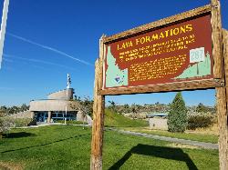
Hell's Half Acre Lava Walk
Blackfoot, Idaho
25.6 miles N of Blackfoot, IdahoThe Lava Trails traverse the desert of the Snake River Plain through contorted landscapes created from multiple lava flows. These Hawaiian-type lava flows are associated with the stretching of the earth’s crust. Hell’s Half Acre lava flow erupted about 4,100 years ago and is 222 square miles or 162,000 acres. The lava flowed at 2,000 degrees Fahrenheit, had the consistency of molasses, and traveled at speeds up to 30 mph.Courtesy of blm.gov
Undeveloped trails offering scenic solitude; short 0.5 mile loop trail and a 4.5-mile trail to the main vent of the Hell’s Half Acre flow. Trails are primitive and marked with poles across lava. A fire ring and other amenities are located at the trailhead.Courtesy of blm.gov

North Menan Butte ('R' Mountain)
Menan, Idaho
4.5 miles N of Menan, IdahoThe North Menan Butte is more commonly known to the locals and college students as R Mountain. Many kids know it better as Ou'R' Mountain. The butte is a rare and unique geological area and provides a great volcanic hike.
There's a paved parking lot and a vault toilet at the West trailhead. The first few hundred yards are well-maintained gravel and sand paths and the further you get, the less defined the trail gets, though it is relatively easy to find and follow. The switchback trails (South and West) are marked by sections of log fences. Towards the top of the West switchbacks, there's a chain handrail. It gets a little steep so you'll want some shoes with some grip. The sand on the rock makes it pretty slippery in the steeper parts. You'll get better grip after a good rain. Once you get up to the top, there's an informational placard. From there, it's easy to hike the rim and get an awesome view of the valley including Rexburg, Henry's Fork, and the Snake River.
It's a great hike for a small family or just a quick hike for a date. Even going up the West switchbacks and around rim, including the 'R', and back down the same way is only 3.5 miles (longest route) so you can do it pretty quick if you want. There's so much to look at that you could also spend hours climbing rocks, exploring caves, and playing around "The Ampitheater". If you just want to get to the 'R' as quickly as possible, you can do the hike in as little as 2 miles roundtrip.
Distances:
- West trailhead up the face to the rim: 0.5 miles
- West trailhead up the switchbacks to the rim: 0.75 miles
- West trailhead, from reaching the rim to 'R': 1 mile
- South trailhead to the rim: 0.3 miles
- South trailhead, from reaching the rim to 'R': 0.75 mile
- Through the caldera: 0.6 miles
- Around the rim: 2 miles
- Rim to 'R': 500 feet
There are no fees. Camping is allowed up to 5 nights but fires must be in an elevated fire pan and all the ash must be packed out.
Posted regulations:
- No motorized vehicle use
- Discharging of weapons or fireworks is prohibited
- Open fires are permitted only with an approved elevated fire pan and ash removal
- Burning pallets, tires, wire, plastic, glass, metal, magnesium, or hazardous material is prohibited
- Cutting or damaging vegitation is prohibited
- 5-day camping limit

Cress Creek Nature Trail
Rexburg, Idaho
11.9 miles S of Rexburg, IdahoMeandering along the scenic South Fork of the Snake River, the beautiful 1¼ mile Cress Creek Nature Trail will lead you on a journey through sagebrush-grass communities, over juniper covered slopes, and along a lush perennial creek. Cress Creek derives its name from the watercress plant, a favorite food of the moose that live in this area. With clear skies, prepare for an expansive view of the Snake River, volcanoes and farmland. The site offers ample parking, restrooms and trail accessibility, which attract a wide spectrum of trail users to the area. You will become familiar with life in the Cress Creek area as it is now and as it was long ago. If you hike quietly you may see deer, rabbits, small lizards, or possibly an eagle or a moose. The nature trail is self-guided with many beautiful interpretive signs posted along the way to assist you. The first half-mile of the trail is accessible by wheelchair.
On the northeastern corner of the trail, there's an overlook trail. Parts of it are pretty nice like the rest of the loop but some is barely recognizable as a trail. Parts of the trail are steep and parts of it go over some pretty loose rock. It goes for about a ½ mile all the way to the top of the hill. Just below the rim, there are several really cool caves. From the top, you can see from Rexburg to Idaho Falls.


