


395 Things to do within 100 miles of Rexburg,+ID,+USA
first prev 2 3 4 5 6 7 8 9 10 11 next lastShowing results within 100 miles Distance miles of Rexburg, ID, USA City, Zip, or Address

Channel Lock
Driggs, Idaho
26.4 miles ETrail is a little over 1 mile uphill. Recommended route up to access the larger Horseshoe canyon trail system. Makes a nice downhill with twists. Gets its name from the deep ruts made from cows....
Mountain Bike
Sharks Belly
Driggs, Idaho
26.5 miles ETrail system can start from Channel lock or Bovine. Channel Lock is an easier climb than Bovine. This description and mileage starts at the Channel Lock trail, forest service boundary marker. Take...
Mountain Bike
Southbound
Driggs, Idaho
26.5 miles ETrail starts by going up the Channel lock trail. At the top of Channel Lock go right onto the Southbound trail. Trail will loop back to Channel lock which you take back to your car. Trail is...
Mountain Bike
Idaho Falls Skate Park
Idaho Falls, Idaho
27.1 miles SWSkateboard near Idaho Falls, Idaho
Skateboard
Woodland Hills
Idaho Falls, Idaho
27.1 miles SGrassy with slight elevation and some young trees that can come into play. Course map near 1st tee and parking lot. An OB irrigation canal comes into play #3 and 4. Fun course layout with some...
Disc Golf
Sand Creek Frenzy
Ashton, Idaho
27.8 miles NThere are some woods back there and it is secluded. There are many places you can play just watch out for campers.
Paintball
South Fork Snake River Trail
Ririe, Idaho
28.2 miles SEGo left at the trail head. It heads down about a mile and a half on double track. Then you'll come to a creek crossing. After the crossing the trail heads across a gate. Head left...
Mountain Bike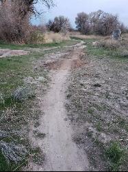
Ryder Park
Idaho Falls, Idaho
28.3 miles SWAdjacent to the pond at Ryder Park is a great little jump park. There are a few different lines of varying difficulty, all of them rather short, and a nice bike path to climb back to the top and do...
Mountain Bike

Ashton Hill
Ashton, Idaho
29.0 miles NEFairly thick forest. Considerable underbrush. Lots of places in the area to play.
Airsoft, Paintball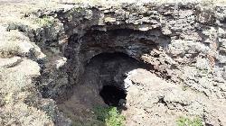
Rexburg Area Ice Caves
Rexburg, Idaho
29.1 miles NNot to be mistaken with the Civil Defense Caves (which are near by), the Ice Caves are about an hour North outside of Rexburg. The Ice Caves were originally formed as lava tubes. Over the years they...
Cave
Twin Creek Trail
Driggs, Idaho
29.2 miles EThe Twin Creek trail is 2.3 miles long. It begins at Trail 6195 and ends at Trail 6219. source: fs.usda.gov
Mountain Bike
Gem Lake Bike Park
Idaho Falls, Idaho
29.6 miles SWBuilt on an old quarry, Gem Lake Bike Park offers a variety of riding. There's no shortages of berms here and there's plenty of space to get some speed, drop in or climb out. The trails here...
Mountain Bike
Pine Butte / The Caldera
St. Anthony, Idaho
30.5 miles NThis is about as close to an oasis as you can get in the deserts of Idaho. It's an old volcano in the middle of the sagebrush desert. As soon as you start down the path, you can feel the air...
Camp, Hike, Horseback
West Pine Creek Trail
Ririe, Idaho
30.7 miles SENon-motorized use. source: fs.usda.gov
Mountain Bike
Trail Canyon Trail
Ririe, Idaho
30.8 miles SEThe Trail Canyon trail begins at Trail Canyon Parklot, T8s R43e Sec28 and ends at Intersect Trail 5251,t8s R43e Sec28. source: fs.usda.gov
Mountain Bike
Big Bend Ridge Trail
Ashton, Idaho
31.0 miles NETrail is open to OHVs. source: fs.usda.gov
Mountain Bike
Big Hole Crest Trail
Driggs, Idaho
31.2 miles EThis is a tough ride. Definately for advanced riders. Lots of climbing and descending. The trail at either end is well used and really fun. Not too much technical riding, just fun...
Mountain Bike 3.2-47.0 mi
Yellowstone Branch Line Trail
Ashton, Idaho
31.5 miles NEYellowstone branch line trail runs from Warm River to the Montana border totaling 39 miles. There are a few places to jump on and off the trail as well as a few smaller trails that branch off of this...
Backpack, Cross-country Ski, Hike, Horseback, Mountain Bike
Warm River Campground
Ashton, Idaho
31.6 miles NEWarm River Campground is located nine miles northeast of Ashton, Idaho, along the slow-moving Warm River at an elevation of 5,200 feet. Willows line the riverbanks and pine trees offer partial...
Camp
Henderson Canyon
Victor, Idaho
31.7 miles SETrail begins as dirt road/double track with numerous "cow" trails breaking off of road. Some of these trails see more tire tracks than others.
Mountain Bike


