


Rexburg Area Ice Caves
Rexburg, Idaho
Cave
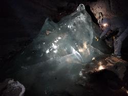
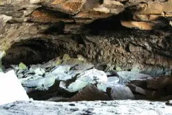
Not to be mistaken with the Civil Defense Caves (which are near by), the Ice Caves are about an hour North outside of Rexburg. The Ice Caves were originally formed as lava tubes. The shape of the caves traps cold winter air in the cave and forms large areas of ice on the floor and beautiful ice crystals on the walls and ceiling. The ice remains frozen year round and makes for an awesome time. The ice caves are a few hundred yards deep and require good footwear, warm clothes and a flashlight to navigate. There is often a good amount of water near the entrance. There's a bridge of rocks across the area but you may get a little wet getting in the cave. There are areas where you'll need a rope to be able to ascend portions of ice. Please do not light fires or introduce any other heat source into the caves.
More Information
Ice Caves - RexburgFun
There are plenty of great things to do in and around Rexburg! A description and directions on how to get to the Ice Caves, located near Rexburg, Idaho.
https://rexburgfun.com/ice-caves/- Plan Ahead and Prepare
- Travel & camp on durable surfaces
- Dispose of waste properly
- Leave what you find
- Minimize campfire impacts
- Respect wildlife
- Be considerate of other visitors
Directions
From Rexburg, Idaho
- Head north on S 3rd W toward W 1st S (0.2 mi)
- Turn left onto ID-33 W/
W Main St (0.9 mi) - Turn right to merge onto US-20 E toward St Anthony (3.1 mi)
- Take exit 337 toward North Rexburg (0.3 mi)
- Turn left onto N Salem Hwy (8.5 mi)
- Continue onto N 1900 E/
N 2000 Rd W/ Red Rd Continue to follow N 2000 Rd W/(18.5 mi)Red Rd - Turn right (1.9 mi)
- Slight right (0.5 mi)
- Slight right (0.7 mi)
- Slight rightDestination will be on the right(43 ft)
Head north out of town, as if you’re driving to the sand dunes. The turn off is just approximately 28 miles past Walmart (when I drove it, my odometer said exactly 28.2 miles). You will know you have arrived at the turn-off when you cross over a cattle guard (a big grated metal thing that crosses the road), and see a white sign on the right side of the road that says, “Entering Clark County.”
jamadeus
8/8/17 6:08 pm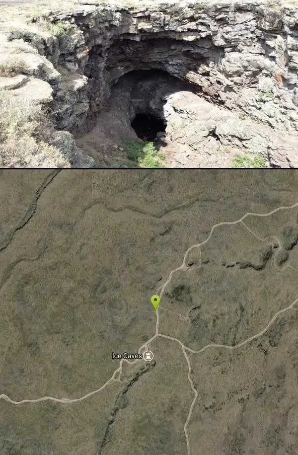 20230808 200427 added by endovereric

 20230808 195516 added by endovereric
 20230808 200232 added by endovereric
 20230808 200331 added by endovereric
 20230808 200451 added by endovereric
 20230808 200714 added by endovereric
 20230808 202803 added by endovereric
 20230808 203058 added by endovereric
 20230808 203351 added by endovereric
 20230808 203529 added by endovereric
 Ice Cave From Trail courtesy of John And Chris↗
 20230808 204250 added by endovereric

Other Caves Nearby
Civil Defense Caves
Rexburg, Idaho
6.3 miles STwo large lava tubes with an arched ceiling, gravel floor, bats in the left branch, and a cavern section at the end — open May through September to protect the bat habitat.
Cave 0.6-2.0 mi
North Menan Butte ('R' Mountain)
Menan, Idaho
33.0 miles SA volcanic butte locals call R Mountain, with a paved trailhead, chain handrails near the top, informational signs at the rim, and views of Rexburg and the Snake River.
Camp, Cave, HikeNearby Campsites

Pine Butte / The Caldera
St. Anthony, Idaho
1.5 miles NWAn old volcano in the Idaho desert that feels like stepping into a mountain forest — pine-covered hillsides, a meadow ringed by aspen and boulders, and a quarter-mile easy trail to the caldera floor.
Camp, Hike, Horseback 4.8 mi
Aldous Lake and Hancock Lake
Kilgore, Idaho
18.3 miles NTwin alpine lakes — Aldous and Hancock — on a scenic 1.5-to-2.5-mile hike near Kilgore, with beautiful mountain scenery and heavier weekend crowds.
Backpack, Camp, Hike, Horseback, Swim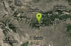
Stoddard Creek
Spencer, Idaho
23.5 miles NWA campground just 1 mile off I-15 and 17 miles north of Dubois, surrounded by trails and wildlife in scenic high desert — an easy-access base for exploring northern Idaho's backcountry.
Camp 0.9 mi
Buffalo River Campground
Island Park, Idaho
25.3 miles NEAn easy, clear, and often warm float on the Buffalo River near Island Park, with slow enough current to paddle back upstream in a canoe or kayak after your run.
Camp, Canoe, Kayak, Swim 0.8-1.3 mi
Warm Slough Campground
Rexburg, Idaho
26.0 miles SA popular river campground with two boat ramps and an easy, slow-moving inner tube float — the take-out is 1,000 feet from the put-in, making multiple runs a breeze.
Airsoft, Camp, Canoe
Warm River Campground
Ashton, Idaho
26.2 miles ESlow-moving warm water and willow-lined banks make this campground a perfect spot for tubing, trout fishing, and peaceful mountain biking at 5,200 ft elevation.
Camp 0.3-0.6 mi
Bear Gulch
Ashton, Idaho
26.6 miles EAn abandoned ski hill from 1969 with overgrown runs that still deliver great sledding — the lower run is fast and winding all the way down to the old ski lift.
Camp, Cross-country Ski, Hike, Sled
Upper Coffee Pot Campground
Island Park, Idaho
27.6 miles NEHenry's Fork of the Snake River winds through a lodgepole pine forest past this campground, offering fly-fishing for rainbow and brook trout and easy tubing and canoeing.
Camp, Canoe 0.2-0.5 mi
Eagle Park
Rexburg, Idaho
28.3 miles SA cottonwood forest park inside Rexburg city limits with campsites, fishing, a dog park, mountain biking on easy and moderate loops, and rock-throwing by the river.
Camp, Hike, Mountain Bike, Sled
Beaver Dick Park
Rexburg, Idaho
29.4 miles SA 9.5-acre Snake River park near Rexburg with fire pits, pavilions, fishing, boating, swimming, and a rich history tied to legendary frontiersman Beaver Dick Leigh.
Camp, Canoe, Disc Golf, Swim
Porcupine Creek
Ashton, Idaho
31.1 miles EA backcountry hunting, fishing, camping, and swimming spot in Targhee National Forest, surrounded by forests, meadows, a creek, and unmarked trails — bear country, so pack and store food carefully.
Camp, Swim
Big Springs
Island Park, Idaho
32.3 miles NEA Big Springs campground shaded by Lodgepole Pines on Henry's Fork — with a 1-mile interpretive trail, fish feeding under the bridge, the historic Johnny Sack Cabin, and access to the Mesa Falls Scenic Byway.
Camp, Hike 0.6-2.0 mi
North Menan Butte ('R' Mountain)
Menan, Idaho
33.0 miles SA volcanic butte locals call R Mountain, with a paved trailhead, chain handrails near the top, informational signs at the rim, and views of Rexburg and the Snake River.
Camp, Cave, Hike 17.5 mi
Tear Drop Lake
Ashton, Idaho
33.6 miles EA small, lively lake in the Targhee forest for kayaking, swimming, and an easy loop trail — family fun with primitive lakeside camping.
Camp, Canoe, Hike, Kayak, Mountain Bike, Swim
Horseshoe Lake
Ashton, Idaho
35.5 miles EA lily-pad-dotted lake hidden in the Targhee National Forest with a gradual beach entry perfect for wading, a floating dock for jumping, and no motorized boats.
Camp, Canoe, Dive, Swim
Sheep Falls on Fall River
Ashton, Idaho
37.3 miles EA local gem off Cave Falls Road where the river splits into multiple falls tumbling over each other — primitive campsites and beautiful views make it a great picnic stop.
Camp
Jefferson County Lake (AKA Rigby Lake)
Rigby, Idaho
37.9 miles SSandy beaches, two floating docks with a slide, volleyball, playgrounds, and a safe swim zone — Jefferson County Lake is eastern Idaho's go-to summer swimming spot.
Camp, Canoe, Dive, Kayak, Sled, Swim 0.5-3.5 mi
Webster's Dam
Ririe, Idaho
39.3 miles SAn abandoned dam in Moody Creek canyon where sediment split the stream into two beautiful 15-foot waterfalls — stunning in spring runoff and blazing with fall colors.
Camp, Hike, Mountain Bike
Twin Bridges Park
Rexburg, Idaho
39.6 miles SA 27-acre Snake River park between two bridges near Rexburg with shaded campsites, fire pits, pavilions, a playground, and BLM ground for hiking and hunting on three sides.
Camp, Canoe
Cave Falls of Yellowstone
Ashton, Idaho
40.7 miles EA campground right on the Fall River along Yellowstone's south boundary puts you steps from legendary fishing, with fire rings and bear-proof boxes at each site.
Camp, Hike


