


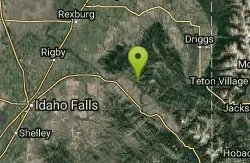
South Fork Snake River Trail
Ririe, Idaho

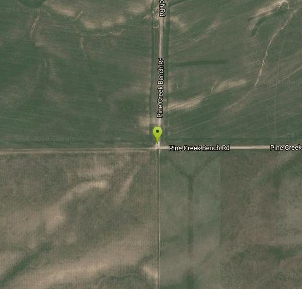
| Address: | ~Pine Creek Bench Rd, Ririe, ID 83443, USA |
| GPS: |
43°31'26.9"N 111°24'35.0"W Maps | Directions |
| State: | Idaho |
| Trail Length: | 15.00 miles |
| MTB Difficulty: | Intermediate |
| Trail Type: | Out & Back |
| MTB Trail Type: | Singletrack |
Mountain Bike
Go left at the trail head. It heads down about a mile and a half on double track. Then you'll come to a creek crossing. After the crossing the trail heads across a gate. Head left after the gate crossing you'll go about 1/2 mile more on double track then the single tracks heads off to the right up the hill. There is a sign for the South Fork trail. Trail heads up to the river bench. It follows the river short drops and climbs mixed in for the first 4 miles. After this point you encounter steep drops with hike a bike climbs. If you don't want to do the hike a bikes turn around at either the 4 or 5 mile mark. This will keep it a fun ride. The hike a bike sections are steep and time consuming. Trail can also be done as a shuttle. Best if rode north to south in this case. Courtesy of Singletracks.com
More Information
South Fork Snake River Trail
South Fork Snake River Trail is a singletrack mountain bike trail in Swan Valley, Idaho. View maps, videos, photos, and reviews of South Fork Snake River Trail bike trail in Swan Valley.
http://www.singletracks.com/bike-trails/south-fork-snake-river-trail/Never modify trail features. Ride trails when they're dry enough that you won't leave ruts. Speak up when you see others on the trail and always yield to hikers, horses, and others coming uphill. Always ride on the established trail.
Read More- Plan Ahead and Prepare
- Travel & camp on durable surfaces
- Dispose of waste properly
- Leave what you find
- Minimize campfire impacts
- Respect wildlife
- Be considerate of other visitors
Directions
From Ririe, Idaho
- Head south on Main St toward Miller St (0.4 mi)
- Continue onto US-26 BUS (1.0 mi)
- Turn left onto US-26 E (27.0 mi)
- Turn left onto ID-31 E/Pine Creek Rd (4.7 mi)
- Slight left onto Pine Creek Bench Rd (1.5 mi)
- Turn right to stay on Pine Creek Bench Rd (0.7 mi)
- Turn left to stay on Pine Creek Bench Rd (1.8 mi)
- Turn right to stay on Pine Creek Bench RdDestination will be on the left(46 ft)
Other Mountain Bike Trails Nearby
South Fork Rim Trail
Ririe, Idaho
5.0 miles NWA motorcycle-designated trail along the South Fork Rim near Ririe, Idaho — check local regulations before bringing other bike types.
Mountain Bike
Blacks Canyon Trail
Ririe, Idaho
5.0 miles NWA Forest Service singletrack from Black Can Road to the Fleming Canyon Trail junction in Ririe, Idaho — open to motorcycles and OHVs up to 50 inches wide.
Mountain Bike
West Pine Creek Trail
Ririe, Idaho
6.1 miles NEA non-motorized trail near Ririe in the Caribou-Targhee National Forest — a quiet, human-powered route for hiking and biking in the Idaho backcountry.
Mountain Bike
Trail Canyon Trail
Ririe, Idaho
6.1 miles NEThe Trail Canyon Trail near Ririe, Idaho runs from the Trail Canyon parking lot to the intersection with Trail 5251 — a straightforward backcountry route.
Mountain Bike 0.6-5.5 mi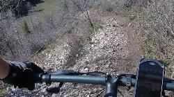
Old Ranger
Ririe, Idaho
6.3 miles NWA diverse, challenging singletrack on a southern-exposure ridge above the Snake River — great for early or late season riding when other trails are still snow-covered or muddy.
Mountain Bike
Burns Canyon
Ririe, Idaho
6.3 miles NWHike and Mountain Bike near Ririe, Idaho
Hike, Mountain Bike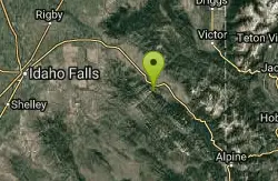
Echo Canyon aka Fall Creek
Ririe, Idaho
6.3 miles STrail goes to the top of Deadhorse Ridge for some amazing views. Double-track, single-track, and gravel road. Length: 15 miles
Mountain Bike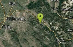
Echo/Indian Creek Trail
Swan Valley, Idaho
6.7 miles SAn OHV trail through the Swan Valley area of Idaho — a rugged option in the Caribou-Targhee National Forest for off-highway vehicle enthusiasts.
Mountain Bike
Wolverine Creek Trail
Ririe, Idaho
9.0 miles NWWolverine Creek Trail is an easygoing doubletrack ride in the Kelly Canyon network above the South Fork of the Snake near Ririe, Idaho.
Mountain Bike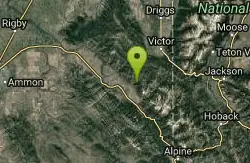
North/South Rainey Creek Trails
Irwin, Idaho
9.1 miles SEA motorcycle trail through the North/South Rainey Creek area near Irwin, Idaho — suited for motorized trail riding.
Mountain Bike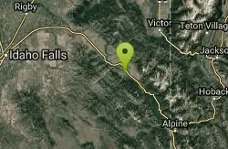
Flat Iron Trail
Swan Valley, Idaho
9.2 miles SEAn OHV trail in Swan Valley, Idaho — a motorized off-highway vehicle route through the national forest.
Mountain Bike
South Fork Fall Creek Trail
Swan Valley, Idaho
9.3 miles SAn OHV trail on the South Fork Fall Creek near Swan Valley, Idaho — open for off-highway vehicle use.
Mountain Bike 1.2 mi
Spooky
Victor, Idaho
9.4 miles EA fun singletrack stem in the Big Hole Mountains connecting to Red Creek, Corral Creek, and more — a satisfying 1.2-mile out-and-back if your time is tight.
Mountain Bike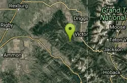
Red Creek Via Spooky Trail
Victor, Idaho
9.4 miles EA fun loop through the Tetons near Victor linking Spooky trail, Red Creek's water crossings, ATV doubletrack with water bar jumps, and Corral Creek trail back to the start.
Mountain Bike
Thousand Springs Trail
Driggs, Idaho
10.2 miles NA singletrack trail beginning at Moody Swamp trailhead and ending at the Prospect Peak Trail junction in Idaho's Teton-area national forest.
Mountain Bike 4.3 mi
Leaning Fir #169
Ririe, Idaho
10.5 miles NWMountain Bike near Ririe, Idaho
Mountain Bike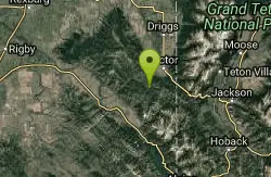
Sheep Driveway
Irwin, Idaho
11.2 miles EA multi-use trail near Irwin, Idaho, open to OHVs, mountain bikes, day hikers, and horse riders alike.
Mountain Bike
Kelly Canyon/Table Rock
Ririe, Idaho
11.6 miles NWTwisty, root-and-rock singletrack near Ririe with enough challenge on the climb and enough air on the descent to keep things interesting.
Mountain Bike
Lower Hawley Gulch Trail
Ririe, Idaho
11.7 miles NWA mostly flat intermediate singletrack through forest and fields in Ririe, Idaho — expect fallen logs, small ponds, rocky stretches, and creek crossings before connecting to a shared ATV doubletrack.
Mountain Bike
Long Gulch/Indian Trail
Swan Valley, Idaho
11.9 miles SA multi-use trail near Swan Valley open to OHVs (under 50 inches wide), mountain biking, horses, and hiking along Long Gulch and the historic Indian Trail corridor.
Mountain BikeNearby Campsites

Fall Creek Falls
Swan Valley, Idaho
6.0 miles SA shaded Snake River campground near Swan Valley with abundant wildlife, great trout fishing, and Fall Creek Falls a quarter-mile away.
Camp, Cave, Hike, Kayak, Swim
Falls Campground
Victor, Idaho
6.8 miles SA Snake River campground near Swan Valley with cottonwood shade, abundant wildlife — eagles, osprey, moose, and deer — and Fall Creek Falls just a quarter mile away; Palisades Reservoir is 20 miles out.
Camp
Pine Creek Campground
Victor, Idaho
10.7 miles EThe Pine Creek Campground has 10 single units and has restrooms.
Camp
Moody Meadows
Driggs, Idaho
11.1 miles NGood place for kids, they can ride bikes in the meadow, play in the stream, and camping is off of the road. Hiking, motorbiking, and horseback riding trails are abundant in the area.
Camp
Wolf Flats Recreation Area
Ririe, Idaho
11.3 miles NWWolf Flats is a completely free, dispersed, undeveloped camping area with 25 locations to camp. Some areas are large enough to accommodate groups of 50 people.
Camp
Table Rock Campground
Ririe, Idaho
11.6 miles NWA campground in Caribou-Targhee National Forest — part of a 3-million-acre stretch from Montana to the Utah and Wyoming borders — with access to the Curlew National Grassland.
Camp 2.8-4.1 mi
Palisades Creek Trail / Lakes and Waterfall Canyon
Irwin, Idaho
13.2 miles SESpectacular mountain views, two landslide-formed alpine lakes, and mountain goat sightings — all within a 4-to-6-mile hike in the Swan Valley wilderness.
Backpack, Camp, Hike, Horseback, Mountain Bike
Big Hole Dispersed Campsites
Ririe, Idaho
14.2 miles NWA network of dispersed campsites with fire rings in the Big Hole mountains above Kelly Canyon — first come, first served, no reservations, and Leave No Trace principles are essential.
Camp
Kelly Island Campground
Ririe, Idaho
14.4 miles NWA BLM campground with 14 family sites and 1 group site for RVs or tents, open May through September — vault toilets, pets welcome, and rates from $5–$20 per night.
Camp
Paramount Wall / Blanche Rock
Ririe, Idaho
14.5 miles NWA sport climbing wall above the road near Ririe with great exposure, afternoon shade, and well-loved 5.9–5.10 lines — most routes work with a 50-meter rope, established by Chuck Oddette and crew.
Camp, Horseback, Rock Climb 0.5-3.5 mi
Webster's Dam
Ririe, Idaho
15.2 miles NWAn abandoned dam in Moody Creek canyon where sediment split the stream into two beautiful 15-foot waterfalls — stunning in spring runoff and blazing with fall colors.
Camp, Hike, Mountain Bike
Calamity Campground
Irwin, Idaho
16.8 miles SEA wooded Palisades Reservoir campground 55 miles east of Idaho Falls with clean blue water for swimming, boating, water skiing, and fishing — plus miles of ATV routes.
Camp, Canoe, Hike, Kayak, Mountain Bike, Swim
Mike Harris Campground
Victor, Idaho
17.2 miles EA scenic mountain campground at 6,200 feet along Teton Pass just 5 miles from Victor, Idaho — a peaceful base for fishing, trail exploring, and sightseeing in the Teton region.
Camp 6.6-6.8 mi
Bear Creek Hot Springs
Irwin, Idaho
19.3 miles SETrek ~13 miles up a creek canyon near Palisades Reservoir to a secluded natural hot spring — gentle most of the way, with one rewarding final climb.
Backpack, Camp, Hike, Horseback, Hot Springs, Mountain Bike
Big Elk Campground
Irwin, Idaho
20.3 miles SEA versatile campground near Palisade Reservoir with fishing, hiking, horseback riding, and kayaking — plus a small secluded lake on the drive in that's perfect for a quiet afternoon.
Camp 6.9 mi
Big Elk Creek
Irwin, Idaho
20.3 miles SEA versatile campground on a small dammed lake with fishing, kayaking, hiking and backpacking into the Caribou-Targhee National Forest, and stunning fall Aspen and Douglas-Fir colors on the Big Elk Creek Trail.
Backpack, Camp, Canoe, Hike, Horseback, Kayak
Twin Bridges Park
Rexburg, Idaho
20.5 miles NWA 27-acre Snake River park between two bridges near Rexburg with shaded campsites, fire pits, pavilions, a playground, and BLM ground for hiking and hunting on three sides.
Camp, Canoe
Darby Canyon Camping
Alta, Wyoming
22.0 miles NEDispersed campsites with fire lays in scenic Darby Canyon — no official campground, just established spots in Wyoming wilderness. Leave No Trace and use existing rings only.
Camp
Indian Creek Campground (Palisades)
Irwin, Idaho
25.2 miles SEA picturesque reservoir nestled between the Snake River and Caribou ranges, just 25 miles from Jackson Hole — a beautiful drive and a wildlife-rich fishing base.
Camp, Hike, Horseback, Swim
Jefferson County Lake (AKA Rigby Lake)
Rigby, Idaho
27.4 miles NWSandy beaches, two floating docks with a slide, volleyball, playgrounds, and a safe swim zone — Jefferson County Lake is eastern Idaho's go-to summer swimming spot.
Camp, Canoe, Dive, Kayak, Sled, Swim


