


Pine Butte / The Caldera
St. Anthony, Idaho

| Address: | St. Anthony, Idaho |
| GPS: |
44°15'50.1"N 111°49'19.8"W Maps | Directions |
| State: | Idaho |
Camp, Hike, and Horseback
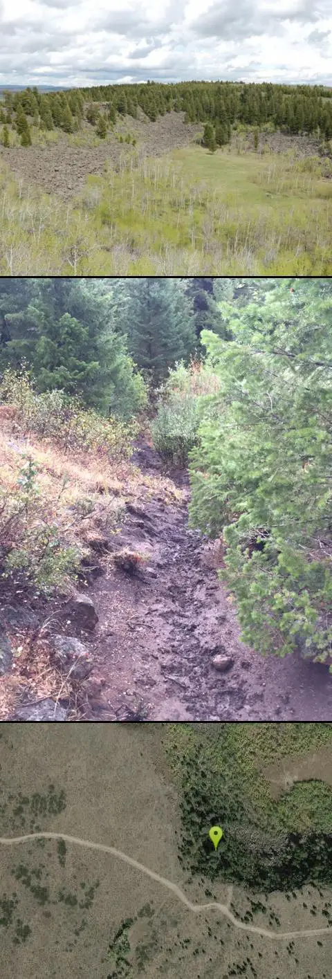
This is about as close to an oasis as you can get in the deserts of Idaho. It's an old volcano in the middle of the sagebrush desert. As soon as you start down the path, you can feel the air change and the vegetation becomes that of a mountain forest. There are a ton of pine trees on the hillsides and a beautfiul meadow at the bottom surrounded by thick aspen trees. The bottom part of the sides nearly all the way around is covered with large boulders great for a little rock hiking if you care to explore. The path in is about as easy a hike as it gets. Maybe a little steep at points but it's only about a quarter mile down in. It's pretty small and there's a pretty established place for fires with plenty of dead wood scattered around.
More Information
Add ResourceBe courteous, informed, and prepared. Read trailhead guidelines, stay on the trail, and don't feed the wildlife.
Read More- Plan Ahead and Prepare
- Travel & camp on durable surfaces
- Dispose of waste properly
- Leave what you find
- Minimize campfire impacts
- Respect wildlife
- Be considerate of other visitors
Directions
From St. Anthony, Idaho
- Head west on E Main St toward S Bridge St (0.7 mi)
- Slight right at S 12th W (469 ft)
- Continue onto 12th W (0.2 mi)
- Turn left onto E 600 N/N Parker RdContinue to follow E 600 N(4.0 mi)
- Turn right onto N 1900 E/Salem RdContinue to follow N 1900 E(4.0 mi)
- Continue onto Red Rd (16.5 mi)
- Turn right (0.9 mi)
- Continue onto Stock Driveway (0.7 mi)
- Turn right (0.4 mi)
- Turn left (0.9 mi)
- Turn rightDestination will be on the left(0.4 mi)


Other Hiking Trails and Horseback Trails Nearby

Aldous Lake and Hancock Lake
Kilgore, Idaho
16.9 miles NTwin alpine lakes — Aldous and Hancock — on a scenic 1.5-to-2.5-mile hike near Kilgore, with beautiful mountain scenery and heavier weekend crowds.
Backpack, Camp, Hike, Horseback, Swim 0.6-4.7 mi
Harriman State Park
Island Park, Idaho
18.3 miles EAn 11,000-acre wildlife refuge 38 miles from Yellowstone along Henry's Fork — world-class fly-fishing, hiking among wildflowers and wildlife, plus 24 miles of Nordic ski trails in winter.
Cross-country Ski, Hike, Horseback, Mountain Bike, Snowshoe
Sheep Falls on Henry's Fork
Island Park, Idaho
21.4 miles EA 25-foot waterfall cascading through a narrow basalt chute on the North Fork of the Snake River — a pleasant, rarely crowded hike compared to nearby Mesa Falls.
Hike
Henry's Fork Green Way (St. Anthony Green Belt)
Saint Anthony, Idaho
21.9 miles SAn easy paved 2-mile round-trip riverside walk along Henry's Fork in Saint Anthony — a statue of fur trader Andrew Henry at the halfway loop, and a pet-friendly, beginner-friendly path.
Hike 2.9 mi
Box Canyon Trail
Island Park, Idaho
23.6 miles NEA scenic 3-mile riverside singletrack along Henry's Fork in Box Canyon — open to OHVs under 50 inches wide, with river views most of the trail and great trout fishing.
Hike, Mountain Bike
Mesa Falls
Ashton, Idaho
25.1 miles EUpper Mesa Falls drops 114 feet and spans 300 feet across the Henrys Fork — just 0.2 miles of paved walkway from the parking lot, with platforms, handrails, and morning rainbow mist.
Cross-country Ski, Hike, Kayak 3.2-47.0 mi
Yellowstone Branch Line Trail
Ashton, Idaho
27.2 miles EA 39-mile trail from Warm River to the Montana border — open to backpackers, hikers, mountain bikers, horseback riders, and ATVs through the Targhee National Forest.
Backpack, Cross-country Ski, Hike, Horseback, Mountain Bike 7.6 mi
Mount Jefferson
Island Park, Idaho
27.3 miles NEIdaho's highest point in the Centennial Mountains crowns a remote 10,203-ft Continental Divide summit on the Idaho-Montana border west of Yellowstone.
Hike 4.2 mi
Lake Marie
Island Park, Idaho
27.3 miles NEA high Continental Divide hike across the Idaho-Montana border to a cold, snowmelt-fed lake in a wildflower meadow — water level shifts dramatically from spring to fall.
Backpack, Hike 0.3-0.6 mi
Bear Gulch
Ashton, Idaho
27.7 miles EAn abandoned ski hill from 1969 with overgrown runs that still deliver great sledding — the lower run is fast and winding all the way down to the old ski lift.
Camp, Cross-country Ski, Hike, Sled 0.8 mi
Conant Creek Pegram Truss Railroad Bridge
Ashton, Idaho
27.9 miles SEA spectacular converted railroad bridge with jaw-dropping views of Conant Creek hundreds of feet below — part of the 30-mile Ashton-Tetonia Trail, with vivid spring and fall colors and Teton backdrop.
Hike 0.2-0.5 mi
Eagle Park
Rexburg, Idaho
29.6 miles SA cottonwood forest park inside Rexburg city limits with campsites, fishing, a dog park, mountain biking on easy and moderate loops, and rock-throwing by the river.
Camp, Hike, Mountain Bike, Sled 0.1-1.3 mi
Hidden Valley Trails
Rexburg, Idaho
30.6 miles SA well-signed network of downhill singletrack flows around the edges of Rexburg, with trails like Flow State, Drop Zone, and Lil' Sendy for every ability level.
Hike, Mountain Bike
Big Springs
Island Park, Idaho
32.2 miles NEA Big Springs campground shaded by Lodgepole Pines on Henry's Fork — with a 1-mile interpretive trail, fish feeding under the bridge, the historic Johnny Sack Cabin, and access to the Mesa Falls Scenic Byway.
Camp, Hike 0.6-2.0 mi
North Menan Butte ('R' Mountain)
Menan, Idaho
34.1 miles SA volcanic butte locals call R Mountain, with a paved trailhead, chain handrails near the top, informational signs at the rim, and views of Rexburg and the Snake River.
Camp, Cave, Hike 17.5 mi
Tear Drop Lake
Ashton, Idaho
34.5 miles EA small, lively lake in the Targhee forest for kayaking, swimming, and an easy loop trail — family fun with primitive lakeside camping.
Camp, Canoe, Hike, Kayak, Mountain Bike, Swim
Lorenzo Boat Ramp
Rigby, Idaho
36.6 miles SHike and Kayak near Rigby, Idaho
Hike, Kayak 1.0-1.3 mi
Lorenzo Bridge
Rexburg, Idaho
36.8 miles SA quiet former boat launch with primitive riverside trails, a hidden lake, stunning fall colors, and a natural paintball field bounded by river and dry creek bed.
Airsoft, Hike, Paintball 2.1-2.3 mi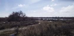
Market Lake Wildlife Management Area
Roberts, Idaho
37.4 miles SWA wildlife management area teeming with waterfowl — ibis colonies, ducks, geese, herons, eagles, hawks, and owls — plus mule deer, white-tailed deer, and a small moose population near Roberts, Idaho.
Hike, Horseback 14.8-15.1 mi
Mr. Bubbles Hot Spring
Old Faithful, Yellowstone National Park
39.3 miles EA remote 15-mile backcountry trek through Yellowstone's Bechler region to a rare wild soak fed by a thermal spring.
Hike, Hot SpringsNearby Campsites
Aldous Lake and Hancock Lake
Kilgore, Idaho
16.9 miles NTwin alpine lakes — Aldous and Hancock — on a scenic 1.5-to-2.5-mile hike near Kilgore, with beautiful mountain scenery and heavier weekend crowds.
Backpack, Camp, Hike, Horseback, Swim
Stoddard Creek
Spencer, Idaho
22.2 miles NWA campground just 1 mile off I-15 and 17 miles north of Dubois, surrounded by trails and wildlife in scenic high desert — an easy-access base for exploring northern Idaho's backcountry.
Camp 0.9 mi
Buffalo River Campground
Island Park, Idaho
25.3 miles NEAn easy, clear, and often warm float on the Buffalo River near Island Park, with slow enough current to paddle back upstream in a canoe or kayak after your run.
Camp, Canoe, Kayak, Swim 0.8-1.3 mi
Warm Slough Campground
Rexburg, Idaho
27.2 miles SA popular river campground with two boat ramps and an easy, slow-moving inner tube float — the take-out is 1,000 feet from the put-in, making multiple runs a breeze.
Airsoft, Camp, Canoe
Warm River Campground
Ashton, Idaho
27.3 miles ESlow-moving warm water and willow-lined banks make this campground a perfect spot for tubing, trout fishing, and peaceful mountain biking at 5,200 ft elevation.
Camp
Upper Coffee Pot Campground
Island Park, Idaho
27.4 miles NEHenry's Fork of the Snake River winds through a lodgepole pine forest past this campground, offering fly-fishing for rainbow and brook trout and easy tubing and canoeing.
Camp, Canoe 0.3-0.6 mi
Bear Gulch
Ashton, Idaho
27.7 miles EAn abandoned ski hill from 1969 with overgrown runs that still deliver great sledding — the lower run is fast and winding all the way down to the old ski lift.
Camp, Cross-country Ski, Hike, Sled 0.2-0.5 mi
Eagle Park
Rexburg, Idaho
29.6 miles SA cottonwood forest park inside Rexburg city limits with campsites, fishing, a dog park, mountain biking on easy and moderate loops, and rock-throwing by the river.
Camp, Hike, Mountain Bike, Sled
Beaver Dick Park
Rexburg, Idaho
30.6 miles SA 9.5-acre Snake River park near Rexburg with fire pits, pavilions, fishing, boating, swimming, and a rich history tied to legendary frontiersman Beaver Dick Leigh.
Camp, Canoe, Disc Golf, Swim
Big Springs
Island Park, Idaho
32.2 miles NEA Big Springs campground shaded by Lodgepole Pines on Henry's Fork — with a 1-mile interpretive trail, fish feeding under the bridge, the historic Johnny Sack Cabin, and access to the Mesa Falls Scenic Byway.
Camp, Hike
Porcupine Creek
Ashton, Idaho
32.3 miles EA backcountry hunting, fishing, camping, and swimming spot in Targhee National Forest, surrounded by forests, meadows, a creek, and unmarked trails — bear country, so pack and store food carefully.
Camp, Swim 0.6-2.0 mi
North Menan Butte ('R' Mountain)
Menan, Idaho
34.1 miles SA volcanic butte locals call R Mountain, with a paved trailhead, chain handrails near the top, informational signs at the rim, and views of Rexburg and the Snake River.
Camp, Cave, Hike 17.5 mi
Tear Drop Lake
Ashton, Idaho
34.5 miles EA small, lively lake in the Targhee forest for kayaking, swimming, and an easy loop trail — family fun with primitive lakeside camping.
Camp, Canoe, Hike, Kayak, Mountain Bike, Swim
Horseshoe Lake
Ashton, Idaho
36.4 miles EA lily-pad-dotted lake hidden in the Targhee National Forest with a gradual beach entry perfect for wading, a floating dock for jumping, and no motorized boats.
Camp, Canoe, Dive, Swim
Sheep Falls on Fall River
Ashton, Idaho
38.4 miles EA local gem off Cave Falls Road where the river splits into multiple falls tumbling over each other — primitive campsites and beautiful views make it a great picnic stop.
Camp
Jefferson County Lake (AKA Rigby Lake)
Rigby, Idaho
39.2 miles SSandy beaches, two floating docks with a slide, volleyball, playgrounds, and a safe swim zone — Jefferson County Lake is eastern Idaho's go-to summer swimming spot.
Camp, Canoe, Dive, Kayak, Sled, Swim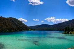
Wade Lake
Cameron, Montana
39.7 miles NWade Lake is a hidden gem of southwestern Montana — a spring-fed mountain lake famous for its glassy, aquamarine water, tucked into a forested ravine at the southern end of the Gravelly Range....
Camp, Canoe, Kayak, Swim 0.5-3.5 mi
Webster's Dam
Ririe, Idaho
40.7 miles SAn abandoned dam in Moody Creek canyon where sediment split the stream into two beautiful 15-foot waterfalls — stunning in spring runoff and blazing with fall colors.
Camp, Hike, Mountain Bike
Twin Bridges Park
Rexburg, Idaho
40.9 miles SA 27-acre Snake River park between two bridges near Rexburg with shaded campsites, fire pits, pavilions, a playground, and BLM ground for hiking and hunting on three sides.
Camp, Canoe
Cave Falls of Yellowstone
Ashton, Idaho
41.7 miles EA campground right on the Fall River along Yellowstone's south boundary puts you steps from legendary fishing, with fire rings and bear-proof boxes at each site.
Camp, Hike


