


12 locations
Add Location
 Full Listing
Show more
Camp, Hike, Swim
Full Listing
Show more
Camp, Hike, Swim
 Full Listing
Show more
Hike
Full Listing
Show more
Hike
1.5-5.0 mi
 Full Listing
Show more
Hike
Full Listing
Show more
Hike
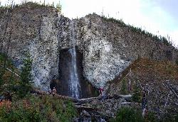
Fairy Falls
Old Faithful, Yellowstone National Park
3.8 miles N of Old Faithful, Yellowstone National ParkFairy Falls is something out of a fantasy novel. Fairy Falls is a wonderful portion of Yellowstone. It has stolen the hearts of many who have had a little pixie dust sprinkled on them from the mist of the waterfall. Fairy Falls is one of the tallest waterfalls in Yellowstone, it stands 197 feet high. The river that feeds this waterfall is naturally thin, which is what gives Fairy Falls its wispy nature. The waterfall is smaller in nature during the dyer months, however in the spring when the snow melts, it is a delightful sight.
The trail to Fairy Falls is also extremely scenic. There are many hot springs that can be spotted, including the famous Grand Prismatic Spring. Because there are many natural springs and sights along the trail, you may find the trail to be quite crowded in the beginning. As you continue on the trail, you will find a much quieter experience. The trail is mostly flat only reaching an incline as you progress into the thicket of the trees. You will then be graced by the majestic view of Fairy Falls.
To get there, you'll cross the steel bridge over Firehole River, then pass over the Grand Prismatic Spring. You will then turn left at the junction and go through the Lodgepole forest near the Fairy Meadows until you reach Fairy Falls. Don't worry, there's no trolls under the bridge, you shouldn't have to answer any riddles, and as far as we know, these are the nice kind of fairies*.
Most of the amazing pictures you see of the Grand Prismatic Spring were taken from somewhere along this trail. There's an overlook just off the trail about 0.75 miles into the trail if you want an even better view.
Fairy Falls gets its name from the "graceful beauty with which the little stream [drops] down a clear descent" and was named by members of the 1871 Hayden Survey. At only 5 miles round trip and only 279 feet of elevation gain, this is one of the more popular non-boardwalk hikes in Yellowstone National Park.
* FREEARENAS.COM IS NOT LIABLE IN THE EVENT THAT YOU OR ONE OF YOUR LITTLE ONES IS CARRIED OFF BY A NOT-SO-NICE FAIRY.
1.0 mi
 Full Listing
Show more
Hike
Full Listing
Show more
Hike
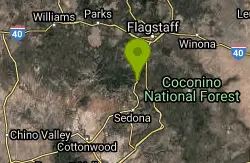
Harding Springs Trail
Sedona, Arizona
9.1 miles N of Sedona, ArizonaHarding Springs Trail is a beautiful hiking trail in Sedona, Arizona. This trail was originally one of several that provided a way for cattlemen to drive their stock in and out of Oak Creek Canyon. This trail was used as a means of travel because it was wide, and very mild Today, many use this trail to admire the beauty encompassed around it. Because this trail isn't steep at all, it is a great hike for all ages. This trail makes for a gradual hike up to the canyon's rim. The hike takes about an hour to finish, and is also mostly shaded. The Harding Springs Trail also has rest stops along the hike, which is great for the summer months when the temperatures can climb to the triple digits.
As you climb to the top of this canyon, you have the option of going back down to the beginning, or continuing north on Cookstove Trail or south on Thomas Point Trail. Overall, this hike is easy, fun, and a great way to escape from the fast pace world. Take advantage of the beauty around Sedona with the beautiful views of the Harding Springs Trail.
3.1 mi
 Full Listing
Show more
Hike
Full Listing
Show more
Hike
Mallard Lake
Old Faithful, Yellowstone National Park
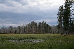
0.3 miles SE of Old Faithful, Yellowstone National ParkThe Mallard Lake trail is majestically lined with trees both old an new. This is a 5 mile leading to the beautiful Mallard lake, making it a 10 mile round trip. The trail is most popularly used for hiking, running, camping, and is best to hike from May-September. The Mallard lake trail gives a spectacular birds eye view of Yellowstone's Old Faithful. The trail is known to change scenery every mile or so, ranging from young and old pine, to rocky terrain, and then grassy meadows. Wildflowers are in abundance on this hike as well. These flowers can be found along the trail and surrounding the lake. The lake is calm, and only experiences disturbances when the wind causes ripples or when the fish create bubbles.
This lake is a little more private, which means it does not get very crowded during the warmer seasons. You can hike to the lake and enjoy a meal with a view, or let all of your senses indulge in the scenic creations. Many of the trees that were knocked down from the Yellowstone fires in 1988 can be used as seats or tables by the lake. Since the fire, the forest along the creek and surrounding the lake has developed into a beautiful, youthful, green woodland.
The lake itself was once known to be overly populated with fish.The rangers in the area tried to combat the over population and saw little success in the past. However when Yellowstone opened the area for public fishing the solution was found. the Mallard Lake is still brimming with lake trout. If you being your fishing gear on this hike, you might come home with dinner!
4.9 mi
 Full Listing
Show more
Hike
Full Listing
Show more
Hike
Riddle Lake Hike
Grant Village, Yellowstone National Park
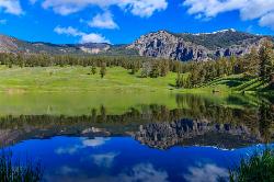
2.8 miles S of Grant Village, Yellowstone National ParkRiddle Lake hike is a 5 mile roundtrip hike. Riddle Lake is an alluring body of water with a sandy beach. The hiker gets the best of both worlds on this hike. Impressive pine and mountain views, meadows, and a lake with a mini beach area.The trail is an easy hike because elevation is hardly detectable, and allows the hiker to focus on the scenery.This hike takes you through a blanket of forest, then a dirt trail. You will pass several tree trunks covered in scratch marks, offering fresh evidence that bears frequent this area*. This hike is closed for a majority of the hiking season due to swans nesting in that area. To know if it is available to hike, contact a park ranger.
The history of Riddle lake dates back a few centuries. It was named by early explorers in the 1800's who were uncertain about which ocean the lake drained toward because it sits so close to the Continental Divide- it was believed flow toward both the east and west oceans and then later discovered that it actually flowed into Yellowstone Lake.
This area does attract a lot of wildlife such as Elk, Moose and Grizzly bears. Upon reaching the lake you can see the Red Mountains to the south. The trail then follows the shore and eventually ends at a black sand beach on the northeast side. Many people stop their hike when they approach the lake, but you can continue around the lake to enjoy the scenery.
This is considered an easy hike with little elevation difference.
*WARNING: To stay extra safe, it is smart to have bear spray with you on your hike and also to make noise while you are on your hike to keep wildlife away. When it comes to wildlife, if you see them on your hike, do not approach them, for your own safety. You can take pictures of wild life but do not approach to pet.
0.4 mi
 Full Listing
Show more
Hike
Full Listing
Show more
Hike
West Thumb Geyser Basin
Grant Visitor's Center, Yellowstone National Park
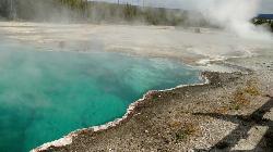
1.8 miles NW of Grant Visitor's Center, Yellowstone National ParkWest Thumb Geyser Basin is one of the smaller geyser basins in Yellowstone, yet its location along the shore of Yellowstone Lake and is ranked as the most scenic. This area was formed by volcanic explosion that took place more than 150,000 years ago. After the volcano exploded, the area collapsed and filled with water over time. It gets its thermal abilities from the enclosed magma trapped in the ring fractures that developed over time.In the 1990's several underwater geysers were discovered. These geysers can be seen as bulges underground, especially during the summer months. The basin is also special because of its location in Yellowstone. The West Thumb Geyser Basin is located on the edge of Yellowstone Lake.
This area features many other springs in the area. As surprising as it is, this area is also one of the least visited areas within Yellowstone. There are boardwalks all along the basin, making it an easy walk to see the beautiful hydrothermal springs in the area. West Thumb's name is derived from the thumb-like projection of Yellowstone Lake and the name was given by the 1870 Washburn Expedition. It was also known as Hot Spring Camp. West Thumb has less geyser activity than other basins. However, amazingly for its size it has all — hot springs, pools, mud pots, fumaroles and lake shore geysers.
0.6-1.5 mi
 Full Listing
Show more
Hike
Full Listing
Show more
Hike
Trout Lake and Buck Lake
Tower Junction, Yellowstone National Park
14.4 miles E of Tower Junction, Yellowstone National ParkThe Trout Lake trail is a steep 1/2-mile trail through a Douglas fir forest which leads to the lake. Trout Lake is also known to be called Fish Lake and Soda Butte Lake .The most difficult portion of the hike is the beginning. Once the lake is in view, the hike gets a bit easier. When you've reached the lake, you are met with beautiful views each way that you look. Behind the lake you can se Mt. Hornaday, which is a beautiful sight year round. In the spring, you may see a gorgeous waterfall forming off to the side of the mountain as the snow cap melts. It's no wonder how this lake got its name, this lake is teeming with trout! Some hikers have even reported seeing otter around the lake area. The otters in the area are said to be familiar with humans and are great about being observed or photographed from a safe distance.
Fishing in this Trout Lake is an enjoyable recreational experience. There are plenty of cutthroat rainbow trout in the lake, however all cutthroat and rainbow trout hybrids caught in Trout Lake must be released. While fishing in this lake is allowed, fishing permits are required. Fishing permits can be purchased at all park ranger stations or visitors centers. All adults are required to purchase a $15 three-day permit to fish. Children under 15 can fish without a permit under the supervision of an adult that holds a fishing permit.
Trout lake sits in a depression on a high bench above the Soda Butte Creek Canyon. Another close by lake is Buck Lake. This lake is another half a mile away from Trout Lake. This is a wonderful hike that leads to a great scenic still lake for a picnic.
Next to Trout Lake you can find Buck Lake. It is another fairly simple hike and is 1.8 miles west of Pebble Creek Campground. The trail can get quite steep as it goes up a slope, but only for a short distance through the forest. Much like Trout Lake, Buck Lake offers the same views and wildlife.
0.5 mi
 Full Listing
Show more
Hike
Full Listing
Show more
Hike
Duck Lake
Grant Village, Yellowstone National Park
1.5 miles N of Grant Village, Yellowstone National ParkDuck Lake Trail is located near Grant Village and West Thumb. This is a simple 0.8 miles hike that takes you through the Lodgepole pine forest. This hike is special because the surrounding forest details the catastrophic effects of 1988 wildfires. The forest also displays its resilience as saplings push through the soil to replenish the forest. The path for the trail begins on the main road across from the parking lot.The trail itself goes up a hill and then as you reach the peak of the hill, the beautiful Duck Lake is exposed.The hill then slopes onto the shore of Duck Lake creating a sandy beach feel.There are many tress that have fallen along the shoreline due to the fire. These trees can be used as a seating area, or picnic area.This trail is great for hikers of all ages.The hardest portion of the hike is the beginning, but making it over the hill will be well worth it. The lake can be enjoyed for its scenic value. Duck Lake has many calming properties because it is a very still lake. Apart from wind forming ripples, you won't see much action in the lake itself. If you'd like, you can also take a stroll along the beach and relax.
Except for the occasional buzz of cars near the west end of the lake, you might have little idea that this lake is just 100 yards from the highway. Many hikers have said that the most peaceful time is during the evening right before the sun sets over the lake.
WARNING: This location is not considered a swimming area and would be best if you wore closed-toe shoes and kept shoes on because leeches have been reported.
Hellroaring Creek Trail
Yellowstone National Park
36.8 miles N of Yellowstone National ParkIf the name didn't scare you enough, the Hellroaring creek trail begins with an arduous descent down to the the Yellowstone River Suspension Bridge.The suspension bridge is a beautiful sight, and is picturesque for photographers on the hike. This descent is matched with switchbacks, and continues for 1.1 miles through the Douglas-Fir forest. The Douglas-fir trees are indigenous to two types of terrain in the United States, mountainous regions where rocky variety of this tree can be found, and coastal areas where this variety thrives. The fir trees particular to the Hellroaring Trail detail the aftermath of the 1988 Yellowstone fires. The perscevereence these trees have can be seen in the new growth that continues to push through in the area. The trail follows along a sagebrush flat, that is met with the peak of Hellroaring Mountain . The Hellroaring Mountain is the largest slab of granite in Yellowstone.
The trail itself is mild and can be enjoyed by all ages. Along the creek by the trail is quite sandy, which creates a mini beach and a swimming area. There are many swimming holes around the hike that can be a lot of fun for hikers, and a great surprise for kids on the hike. If you loved the area and wish you could stay forever, there are several campsites in the Hellroaring Creek area. You might not be able to stay forever, but you can camp over night and take advantage of its beauty and swimming holes the next day.
Both of the Hellroaring Creek and Yellowstone River are colossal fishing areas, they have cutthroat, rainbow trout, brook,brown, and whitefish. In many areas of Yellowstone, there are fishing restrictions. You need to have a fishing permit that can be purchased at any of the ranger spots in the park. This is the Yellowstone fishers heaven. The Yellowstone River is home to the world's premier cutthroat and rainbow trout and the longest undammed river in the United States. With a variety of fish this large, and exquisite quality, it would be difficult not to go home with dinner! The sight offers plenty of fun for all, even if it sounds a little scary.
Check https://www.nps.gov/yell/planyourvisit/swimming-soaking.htm for closures, regulations, and conditions.
0.1 mi
 Full Listing
Show more
Camp, Canoe, Kayak
Full Listing
Show more
Camp, Canoe, Kayak
Lewis Lake Campground
Grant Village, Yellowstone National Park
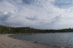
8.5 miles S of Grant Village, Yellowstone National ParkLewis Lake is located in the southern part of Yellowstone National Park. It is 4 miles southeast of Shoshone Lake. Lewis Lake offers a plethora great water activities. This lake offers canoeing, kayaking, hiking, fishing, and beautiful views. Lewis Lake is the third largest lake in Yellowstone's national park. There is a boating ramp as well as roadside access to the lake. If you come to the lake to fish, the best times to fish at Lewis Lake is mid-June and mid-October. It is important to observe the fishing regulations in this area. Because there has been an increase in the amount of anglers in the park, Yellowstone has had to adopt new rules and regulations. Some of these restrictions include: opening/closing dates, bait usage, areas where you can only catch and release, as well as number limits within the area. Some areas within the lake are closed to the public due to endangered fish species.
The campground has onsite staff, food lockers, and potable water. It is located close to the edge of the lake. The campsite is open from mid June to early November. Each campsite comes with a table, and a fire ring. Campground amenities include vault toilets and drinking water. Firewood is also available for sale from the camp host. It is important to note that this campsite is on a first come first serve basis.The campground is located on the southeast shore of Lewis Lake. Six miles to the north of the lake is Grant Village, where you can find restaurants, a gas station, gift shops and camper services.
Kayaking is permitted on this lake, however kayaks are not provided. If you plan to kayak, bring one with you! Motorized boats are also allowed this lake, however rentals are not provided. If you plan to boat on Lewis Lake, please read up on boating regulations.
Due to freezing temperatures, drinking water may not be available in Lewis Lake Campground beginning early to mid-October. Fall campers should plan to bring their own water. If used, lake water must be treated or boiled before consumption.
1.1 mi
 Full Listing
Show more
Hike
Full Listing
Show more
Hike
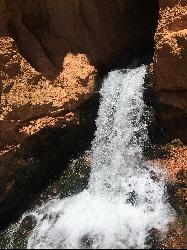
Cascade Falls
Cedar City, Utah
20.6 miles SE of Cedar City, UtahCascade Falls, located outside of Cedar City, Utah, is a beautiful waterfall that is just a 1.2 mile hike round trip, ending at Cascade Falls. It is somewhat of a hidden local hotspot that not many outside of the area know much about it. The hike itself is very family friendly in that small children can likely make the hike, keeping both parents and children happy. There are several landmarks to take note of as you hike the Cascade Falls trail. One landmark is the stairs that were meticulously plotted along the trail which add both an element of comfort and beauty to the hike as they match the sandstone landscape. Another landmark to look out for is the upper Cascade Falls viewpoint where hikers are allowed to get an up close view of these beautiful falls.
The water from the waterfall derives from the Navajo Lake that then funnels into a series of sinkholes in the area. This water is special because before it reaches the falls, it travels through many underground water tubes. The falls can be seen multiple times throughout the hike. When you approach it in the end, you won't be able to swim or go in, but you can definitely take advantage of the views!
Although the hike is short, it is fairly steep in parts, so be prepared with water and some snacks as you hike in the area. Located in the red cliffs just outside of Cedar City, visitors have a great view of the Cedar Valley and Zion National Park. The best times to hike the Cascade Falls trail is from June to September to avoid runoff from snow melts and icy trail conditions. If desired, hikers have the option of hiking up to Navajo Lake which feeds the beautiful Cascade Falls.
There are benches along the hike to ease the hikers on their journey as well as encourage the hiker to enjoy the magnificent views through the canyon. The trail is very well maintained, and remains about the same in elevation until you get to the final few yards, then the elevation kicks in a little bit.There is hardly any shade on the hike, so be sure to bring sunscreen, water, and a hat to protect your skin from sunburn. To beat the sun, you could complete this hike in the morning or the evening. This hike is superbly short, making it great for families and busy people who still want to get their fill of nature while accomplishing other task for the day.
This hike is proof that Cedar City and Cedar Breaks National Forest are no mere stopping point on the way to St. George. Cascade Falls will take your breath away making you wanting to come back for more!
0.3 mi
 Full Listing
Show more
Hike
Full Listing
Show more
Hike
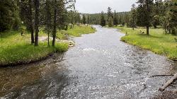
Yellowstone River Picnic Area Trail
Tower Junction, Yellowstone National Park
0.8 miles E of Tower Junction, Yellowstone National ParkThe Yellowstone River Picnic Area trail is 3.9 miles loop trail. It is called the Yellowstone Picnic Area trail because the beginning of the trail is in a picnic area.This hike features a beautiful river, and is a great hikers of all ages. You will gain 450 ft of elevation on this hike. Most of the elevation will be gained on the fairly steep incline at the start of the hike. When you find yourself at the top of the ridge, that is where the trail begins to ease up.Yellowstone River Picnic Area Trail includes a beautiful lookout, and displays exquisite views of the canyon. The canyon exposes the ridges and carvings due to years of erosion.This hike is fairly popular, which is why during nicer weather the trail can be very crowded. The trail is on the cliff side of the canyon following the Yellowstone river. Dependent on the season, you can expect to have many wildlife sightings. Having many opportunities for wildlife sightings is always fun for adults, but can be an incredible learning opportunity for children.
There is a portion of the hike that leads you through meadows. This is where you will see the majority of the wildlife. As you hike along the rim of the canyon, it is free of trees allowing into view the steam vents down by the river. In all, this hike is a beautiful beginner friendly hike. It features many beautiful animals and an amazing scenery.
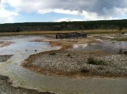
Sentinel Meadows & Queen's Laundry
Madison, Yellowstone National Park
5.5 miles S of Madison, Yellowstone National ParkThe hike to Sentinel Meadows and Queens Laundry gives you a level trail with wide open meadows, hot springs, ponds, birds, and a little bit of Yellowstone National Park history. The trail can be done by hiking directly to Queens Laundry and back or made into a little loop that’s a bit longer through another meadow. Courtesy of hike734.com
Sentinel Meadows and Queen's Laundry is a hiking trail that follows the Firehole River. Flaming red hot springs and beautiful oat colored meadows can be seen on this trail. The construction of Queen's Laundry, is a historic site that dates back to the 1800's when people used the geothermal pools to bathe. The thermal water provided a relaxing bathing experience, while having amazing cleansing properties.The idea behind the laundry was that it was the first structure built at its time that was a hot spring fed bathing pool. Half of the structure was intended to be for bathing, while the other half was for the laundry. Unfortunately, the laundry was never completed, and as ownership of the park changed overtime, the structure remained a half finished bath/laundry. What is left of the structure can still be seen today in almost perfect condition. The minerals emitted from the hot springs surrounding the area preserved the structure, and it is now considered a historic site.
It is important to know that going off trail is not permitted on this hike. There are dangerous hydrothermal areas that can cause injury if they are encountered. However these areas are a beautiful sight from the trail, as it glows shades of orange, burnt orange, and copper.This is a moderate hike, and is 4.7 mile trail that leads straight to the hydrothermal springs. There is little change in elevation, which makes this hike brilliant for all ages. Bison have been seen here as well as other deer and caribou species. This hike is extremely scenic, and true of Yellowstone's beauty.
×


