


942 Yosemite by smbrady17
first prev 1 next lastYosemite National Park is home to some of the biggest and most well-known waterfalls, including Yosemite Falls, Nevada Falls, Sentinel Falls, and more. Discover which have the best hikes for you to enjoy next time you're at the park.

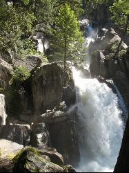
Snow Creek Falls
Yosemite Valley, Yosemite National Park
3.5 miles NE of Yosemite Valley, Yosemite National ParkSnow Creek is one of the more difficult waterfalls to find in the valley, but in the spring and summer months, the elusive waterfall can be seen from the Mirror Lake Trail, a 5 mile loop around Mirror Lake.
The first mile of the Mirror Lake Loop is a flat, straightforward path to Mirror Lake, one of Yosemite's most popular swimming holes. Continuing around the lake, the trail eventually meets the Snow Creek Trail, a separate, strenuous 9 mile hike. It's at this junction that Snow Creek Falls can be spotted.
Snow Creek Falls is 2,140 feet of cascades enveloped in Tenaya Canyon. The entire fall is made up of seven separate drops, the longest being 500 ft. Because of the deep recesses of the rocks it flows over, it is almost tucked away inside the canyon. But if you know where to look, you can find it.
Mirror Lake Loop is the least strenuous way to access the falls, and you can stop for a swim on your way over. However, if you're looking for something more challenging, Snow Creek Falls can also be seen from the "Diving Board," an obscure rock protrusion at the Half Dome summit.
Chilnualna Falls
Wowana, Yosemite National Park
1.0 miles NE of Wowana, Yosemite National ParkLocated near the southern entrance of the valley, Chilnualna Falls is one of the lesser known waterfalls in Yosemite. The hike is about 8 miles round trip and takes you to the upper part of the falls which runs into a few small nature pools. The lower 240 ft are difficult to see from the top, but can be seen at various points throughout the hike. The best view of the entirety of the falls is when you're about a quarter of a mile away, but a switchback leads you back into the forest and away from the water.
Although it's a steady climb up, the hike also takes you through several forests and you can stop at Chilnualna Creek on your way up. Because the trail goes in and out of shady wooded areas, it's not too difficult to keep cool if you go early enough. In the spring, there will often be mist rising from the falls and the creek that help cool you down as well.
Horses are allowed on this trail. There is a fork in the trail towards the beginning of the hike. The left allows horses, and the right is for hikers only. Watch out for rattlesnakes and the ocassional poison oak.
Illilouette Falls
Yosemite West, Yosemite National Park
2.8 miles SE of Yosemite West, Yosemite National ParkIllilouette Falls Trail is a 4 mile hike down to Illilouette Creek, where there is a footbridge, a great view of Illilouette Falls, and several benches for onlookers to stop, rest, and enjoy a snack. The hike begins at Glacier Point, but it actually starts going downhill, making the return trip the more difficult one of the two.
To get an even better view of the falls, some choose to take the Panorama Trail once reaching the creek. This trail is an extra mile long and leads to a slightly dangerous lookout over Illilouette Falls. The Panorama Trail is peaceful, less traveled, and it's not uncommon for hikers to come across deer on their way to the Falls. The first half of the Panorama Trail also provides views of Half Dome and Nevada and Vernal Falls. After reaching the lookout, you can turn around and make your way back to the car, or you can continue on for another three miles to reach the mist trail.
Like most waterfalls in Yosemite Valley, Illilouette Falls flows all year but is at its peak in the spring and summer months. In the fall and winter months, the falls tend to dry up.

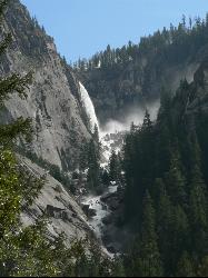
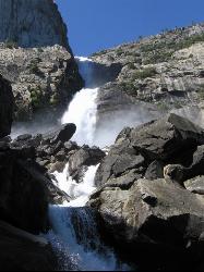
Mist Trail
Yosemite National Park
9.2 miles S of Yosemite National ParkThe mist trail is a small breakoff from the John Muir Trail through Yosemite National Park. It's called the mist trail because of the heavy amount of mist that hikers walk through as Vernal and Nevada Falls crash hundreds of feet below. The hike is short as for horizontal distance traveled but the incline will give you a run for your money. You'll ascend 639 stone stairs to reach the top of Vernal Falls. There's a waterfall in between the two that is a sight all it's own but is often forgotten because of the behemoths on either side. The hike between the falls is a nice break as it is fairly flat relative to the rest of the trail. Once you get to the base of Nevada Falls, you'll have to take switchbacks up the giant cliffs to the top.
These waterfalls are usually the last to dry up around Yellowstone Village. Whether you just love waterfalls or you want a closer view of Halfdome, Whitecap, or Mt. Broderick, the Mist Trail definitely offers world class views. There are bathroom facilities just above Vernal Falls and water just before you start to ascend the stairs. There's another trail that is less steep but that skips Vernal Falls.
Distances (one-way):
| Hike | Distance | Elevation Gain |
|---|---|---|
| Vernal Fall Bridge | 0.8 miles | 400 ft |
| Top of Vernal Falls | 1.5 miles | 1100 ft |
| Top of Nevada Falls | 3.4 miles | 2230 ft |
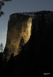
Horsetail Falls
Yosemite Valley, Yosemite National Park
2.2 miles SW of Yosemite Valley, Yosemite National ParkHorsetail Falls is located near El Capitan Valley in Yosemite. Around mid to late February, the fall gains popularity due to the way the orange glow of the sunset radiates off of it. In order to witness this "firefall" phenomenon, there has to be enough snowmelt for the water to flow, and the sky has to be clear. Even a small amount of clouds could reduce the effect or eliminate it altogether.
While it is possible to view from the car, permits are now required to park at the viewing spot. You can reserve a parking permit online, but there are only 250 available. If the permits run out before you can grab one, or you'd rather walk, you can take the short walk from Yosemite Valley Lodge.
The hike is 1.5 miles from the lodge to the viewing spot and runs along Northside Drive. An extra .4 miles will take you to the El Capitan Picnic Area, where picnic tables are available, so you can watch the "firefall" and enjoy a meal. Because the phenomenon happens at night, be sure to prepare accordingly. You should take a flashlight, jacket, and gloves. The average low temperature in February is 30 degrees Fahrenheit.
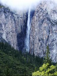
Ribbon Falls
Yosemite Valley, Yosemite National Park
3.0 miles SW of Yosemite Valley, Yosemite National ParkStanding at 1612 ft tall, Ribbon Falls is one of the tallest waterfalls in Yosemite Valley and the longest single-drop waterfall in North America.
It's visible from El Capitan road as you enter the valley. There is turn out for parking available just outside the turn for Bridalveil Falls.
While there is no park designated trail to Ribbon Falls, there is a rough trail that is unmarked. If you prefer a less adventurous hike to see the falls, the Bridalveil Falls viewing spot also offers views of Ribbon Falls as well. Bridalveil Falls is a short, .5 mile walk from Southside drive to the base of the falls. Once you reach the viewing point at the end of the walk, Ribbon Falls is on the opposite side of the valley, across from Bridalveil.
Ribbon Fall is a seasonal waterfall, meaning it is usually flowing in early spring after the snow melts, but it dries up pretty quickly, usually by mid-summer. It is also sometimes difficult to see if you go too late in the afternoon or too early in the morning, due to the shadows that cause the fall to make it look shorter than it actually is. The best time to go is late morning and early afternoon, when the sun is hitting the falls directly.
There IS a trail to the base of Ribbon Falls, and it is not difficult to follow; it fact, it's almost easy. It isn't paved, it isn't graded, and there are no signs to guide you. After you leave the trailhead, as seen in the previous photo, just follow the informal, well-worn trail, which is clearly visible about 98% of the way to the base of the falls. There are stategically placed rock cairns to guide you. If by some slight chance you lose the trail - highly unlikely - just head uphill, and keep Ribbon Creek within listening distance, and within seconds, you'll see the trail or a rock cairn...Courtesy of erench.com
Bridalveil Falls
Yosemite Valley, Yosemite National Park
3.5 miles SW of Yosemite Valley, Yosemite National ParkKnown for being the focal point for one of Ansel Adams' most famous photographs, Bridalveil Falls is one of the first waterfalls you see as you enter Yosemite. The path to get there is a quick, easy half mile hike, making it a great introduction to the park. It gets its name from the mist that rises up from the falls and usually soaks onlookers -- it resembles a bride's veil. Although it's not as tall as Yosemite Falls (no North American waterfall is), it still towers over the valley at 620 feet tall.
The trail is pretty simple. You can park outside the trailhead to a paved path that will take you to the viewing point, but it goes straight through a range of trees. It's easy to navigate once you're there, but difficult to make out on a map.
Although it is one of the few that flows year round, the water from the falls is at its peak in the spring and summer, where it's likely you will get wet from the viewing point, and in the winter, the path can get pretty icy and slippery. The trail is completely paved, so it is wheelchair accessible and pets are permitted as long as they're on a leash.
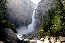
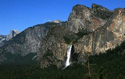
Lower Yosemite Falls
Yosemite Valley, Yosemite National Park
0.2 miles W of Yosemite Valley, Yosemite National ParkYosemite Falls is 3,967 feet high, making it twice as tall as the Empire State building, ten times as tall as Niagara Falls, and one of Yosemite Valley's biggest attractions.
Lower Yosemite Falls trail is short, easy hike that offers views of the entirety of North America's tallest waterfall from its base. The trail is so short and flat that it's essentially just a brisk walk. It will lead you to a footbridge where you will likely get sprayed with water if you are visiting during spring or early summer. By early fall and late summer, though, the waterfall will dry up, so make sure you plan accordingly.
Although the hike doesn't offer much until you reach the falls, there are several places to stop, rest, and read about the history and significance of the iconic waterfall.
Once you've admired the waterfall, taken tons of photos and gotten completely soaked, you can cross a bridge over Yosemite Creek to loop back to the shuttle stop or make your way east, past Yosemite Village toward Mirror Lake, a popular pool a couple miles away.
Rainbows can sometimes form at the base of the lower falls when the moon is full, a phenomenon called "moonbows."
Wapama Falls
Groveland, California
25.3 miles E of Groveland, CaliforniaA 5 mile hike along the shoreline of the Hetch Hetchy reservoir will take you to one of Yosemite's famous waterfalls. The hike to the fall is moderate, takes about 2.5-5 hours to complete and offers views of Tueeulala, mountains and the reservoir.
Wapama Falls currently stands at 1000 ft, but it was an extra 400 ft taller before the dam was built. Once the water raised from the dam, the bottom of Wapama Falls became engulfed into the Hetch Hetchy Reservoir.
This hike is one of the most engaging hikes in Yosemite. Walk over a bridge to cross the O'Shaughnessy Dam, go through a short tunnel, and prepare to get sprayed by the falls. Though the hike is along the reservoir, boating and swimming is not permitted, which adds to the solitude and peacefulness of the hike. There is a bridge at the bottom of Wapama Falls that offers different viewpoints of the falls, the Hetch Hetchy reservoir, and the O'Shaughnessy Dam, but it's possible for the water to get high enough to flow over the bridge after particularly wet winters.
Because of the power of the raging waters, Wapama Falls trail stays closed throughout the winter and early spring. Even once the trail is open, it is still possible the water may be too high, flooding the bridge and making it dangerous and impassable. Later in the season is the best time to visit because the water is low enough to make crossing the bridges and exploring the reservoir safe. The hike to see Wapama Falls is a relatively short trail that offers some of the most amazing views of a part of Yosemite few people take the time to visit.
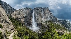
Upper Yosemite Falls
Yosemite Valley, Yosemite National Park
0.9 miles NE of Yosemite Valley, Yosemite National ParkYosemite Falls is the tallest waterfall in North America, standing at 2,425 feet. It's made up of Upper Yosemite Falls, Lower Yosemite Falls, and the middle cascades. Lower Yosemite Falls has its own one mile hike that takes you around the base of the falls if you're looking for something a little less strenuous.
With an elevation gain of about 2600 feet, the hike to the top of Yosemite Falls is one of the more difficult day hikes in the park. It's about 7.2 miles and is filled with steep, rocky switchbacks. Many hikers choose to turn around at Columbia Rock, which is about two miles in and offers great views of Half Dome and Yosemite Falls. But to see it from the top, it's about an extra five miles going straight up.
The falls dry up as early as August, so make sure to visit in the spring after the snow melts.


