


1 locations
Add Location
3.8-6.4 mi
 Full Listing
Show more
Camp, Hike
Last visited on 4 May 2022
Full Listing
Show more
Camp, Hike
Last visited on 4 May 2022
Table Rock / Table Mountain
Driggs, Idaho
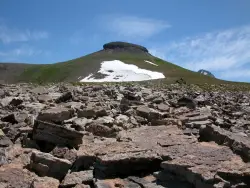
10.0 miles E of Driggs, IdahoAt roughly 11,100 feet, the flat-topped summit of Table Mountain serves up what many consider the single finest view of the Grand Teton anywhere — and one of the great day hikes on the quiet, western (Idaho) side of the range. From the broad mesa top you stand just far enough back to take in all three Teton peaks at once, yet close enough to pick out the detail on the Grand's sheer east face across the deep gulf of the canyon. It's a jaw-dropping payoff, and a hard-earned one.
The mountain holds a remarkable place in history. In 1872, pioneering survey photographer William Henry Jackson hauled his heavy glass-plate camera gear by mule to the top of Table Mountain and made the first photographs ever taken of the Grand Teton — images that helped introduce the range to the wider world and build support for protecting it. Jackson chose this peak precisely because its gentle western slopes could be reached without technical climbing, and that's still what makes the summit attainable for strong day hikers today.
The trailhead sits at the end of Teton Canyon Road outside Driggs and Alta, and nearly the entire route lies within the Jedediah Smith Wilderness of the Caribou-Targhee National Forest. There are two main ways up, and both climb over 4,000 feet. The Face Trail is the steeper, shorter option (about 3.5 miles one way), skipping the switchbacks to head more or less straight up. The Huckleberry (North Fork) Trail is longer but far more gradual (about 6.5 miles one way), following and crossing the North Fork of Teton Creek — handy spots to filter water — through meadows and, in mid-to-late summer, ripe huckleberries for those who beat the crowds to the bushes. Many hikers link the two into a big loop of roughly 11–13 miles, and tough-but-knee-conscious hikers generally prefer to climb up the steep Face and come down the gentler Huckleberry, sparing their knees the pounding of a steep descent. The lower trail is a delight in its own right, tracing rushing Teton Creek past a string of waterfalls.
The wildflowers here are spectacular. As the snow recedes, Table Mountain's meadows erupt in color — sweeping displays of lupine, arrowleaf balsamroot, and Indian paintbrush, with columbine in the shadier pockets and delicate alpine blooms up high. In the Tetons the canyon meadows tend to peak from early-to-mid July, while the highest ground saves its show for late July into August; even when snow still blocks the upper trail, the lower meadows near the trailhead put on an easy, photogenic display. It's one of the finest wildflower hikes in the region.
This is high, exposed country, so plan accordingly. At over 11,000 feet the air is thin and the weather changes fast: afternoon thunderstorms build quickly over the peaks in summer, so start early and aim to be off the open summit by early afternoon. Table Mountain is enjoyed year-round — it's a popular snowshoe and backcountry-ski destination in the snowy months. If you're after dry summer hiking, though, know that you're likely to encounter snow on the upper mountain before mid-July: early-season snowfields often begin around 9,500 feet with larger patches up high, and the Huckleberry side can hold avalanche debris and downed trees until it melts out. It's frequently still passable with the right footwear — just come expecting it. Conditions are typically most reliably snow-free from about mid-July through September. It's also easy to lose the trail, especially on the descent, so pay attention to your route and carry a map or GPS. Keep an eye out for wildlife, too — moose are a common sight in the canyon, and the area is home to the occasional mountain lion.
Bring layers, sun protection, plenty of water (and a filter), and sturdy footwear for the long, steep grade. You can check current conditions on the webcams at tetoncam.com before you drive up. Backpackers sometimes camp in the meadows below the summit to catch the Grand at sunrise — an unforgettable sight — while following Leave No Trace and wilderness regulations. However you do it, Table Mountain earns its reputation: a leg-burning climb to a mesa in the sky, carpeted in wildflowers, with the Grand Teton filling the horizon just as it did for Jackson a century and a half ago.
×


