


Gargantua
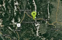
Crowsnest, Alberta, Canada

| Address: | Crowsnest Pass, AB T0K 0M0 Canada |
| GPS: |
49°33'54.0"N 114°35'18.0"W Maps |
| State: | Alberta |
Cave
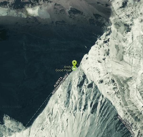
Gargantua is one of Canada's most extraordinary caves — a vast limestone system high on the Andy Good Plateau, a barren alpine karst landscape straddling the Alberta–British Columbia border near Crowsnest Pass in the Canadian Rockies. It holds the largest natural cavern in the country, a single chamber roughly 290 metres long, 30 metres wide, and 25 metres high, part of a system with over six kilometres of mapped passage descending some 286 metres into the mountain.
This is serious, expert-only alpine caving, not a casual outing. The cave's entrances sit above 2,000 metres, at or beyond the timberline, and simply getting there is a mountaineering effort: from the Alberta side it's roughly 7.5 km one way to the plateau with about 710 metres of climbing, numerous creek crossings, and a steep final ascent to the hanging valley, followed by off-trail route-finding up the valley walls to the cave entrances. The B.C. approach is harder still.
Gargantua is genuinely dangerous and beyond the ability of many cavers. The interior involves technical vertical work, frigid water, and a notorious waterfall passage near the exit — a group was once trapped overnight after failing to get through it. This is a trip only for experienced, properly equipped, and trained cavers traveling with people who know the system, with full alpine and vertical-caving gear, and a solid plan. It is not a place to wander into.
For those with the skills, Gargantua is a world-class objective and a crown jewel of Canadian speleology, set in some of the most spectacular high country the Rockies have to offer. For everyone else, it's an awe-inspiring piece of the underground world best appreciated from afar — and a reminder of just how wild the Crowsnest Pass backcountry really is.
More Information
Gargantua (cave) - Wikipedia
Gargantua is a limestone cave located on the Andy Good Plateau in Alberta and British Columbia, Canada. As of 2002[update] it has 6,001 metres (19,688 ft) of passages with a depth of 286 metres (938 ft).[1] It contains the largest natural cavern in Canada at 290 metres (950 ft) long, 30 metres (98 ft) wide and 25 metres (82 ft) high.[2]
https://en.wikipedia.org/wiki/Gargantua_(cave)Gargantua Caves Crowsnest Pass, Alberta Canada
In August my husband and I, along with a group of family members, travelled to the Crowsnest Pass area of Alberta for a trip through the Gargantua Caves. It was one of the most challenging things I’ve ever done but it was definitely worth it and I wanted to tell you a little bit about […]
https://simpleasthatblog.com/gargantua-caves-crowsnest-pass-alberta-canada/To The Mountains I Go: Gargantua Cave (B.C. Access)
Very long hike Distance: · To the cave: 12km · Cave: 2-3km · Back to ca...
http://tothemountainsigo.blogspot.com/2014/08/gargantua-cave-bc-access.html
- Plan Ahead and Prepare
- Travel & camp on durable surfaces
- Dispose of waste properly
- Leave what you find
- Minimize campfire impacts
- Respect wildlife
- Be considerate of other visitors
Directions
Do not follow Google Directions. Try these instead:
Trailhead: Turn south off of Highway 3 just east of the bridge over Crowsnest Creek, 11 km west of Coleman. Drive on the gravel road for 3 km and park at the junction. The route follows the rough road to the left (south). The first 2/3 of this route cross back and forth over the bubbling waters of Ptolemy Creek and can make for a nice outing in itself. At the end of the road, a well-defined trail climbs very steeply up through the forest to a rocky pass into the moonscape of ‘The Promised Land’. There are several significant caves in the immediate area, including Cleft Cave, Gargantua Cave, and Yorkshire Pot.Courtesy of gocrowsnest.ca
Follow hwy 3 out of Alberta into B.C. and take a left onto Corbin Rd, it is a road to a Coal mine (there is a sign). Follow this road for a bit, then take a left turn onto a dirt road just before a railway crossing. Follow the dirt road, there will be other turn offs but they lead to trapper huts. Just follow the road until you reach a dried creek bed. It looks like people have camped there before.Courtesy of tothemountainsigo.blogspot.com


Other Caves Nearby
Nearby Campsites
Kintla Campground
Glacier National Park
44.9 miles SEA 26-site campground on the shores of Kintla Lake inside Glacier National Park — fire pits, bear boxes, vault toilets, and the Kintla Lake Trail at your doorstep.
Camp
Cameron Lake
Waterton, Glacier National Park
45.2 miles SEA picturesque Canadian glacial lake in Waterton Lakes National Park surrounded by mountain scenery, avalanche-sculpted shores, kayaking, fishing, and Herbst Glacier views.
Backpack, Camp, Hike


