


136 Hiking Trails near Hidden Valley from Buena Vista Trail
first prev 1 2 3 4 5 6 7 next lastShowing Hiking Trails within 50 miles Distance miles of N Buena Vista Rd, Phoenix, AZ 85042, USA City, Zip, or Address
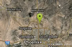
Dixie Mountain Loop with Two Summits
Phoenix, Arizona
27.7 miles NHike, Horseback, and Mountain Bike near Phoenix, Arizona
Hike, Horseback, Mountain Bike
Western Vista Trail
Phoenix, Arizona
27.7 miles NFairly difficult short Trail to one of the summits on the Dixie Mountain Loop. Great views from the top as well as a birds eye view of the gravel pit below.
Hike 2.8 mi
Desert Tortoise
Phoenix, Arizona
27.7 miles NAt just over a mile long, Desert Tortoise is a doubletrack connector to the Valle Verde Trail. Very good hiking area with a good range of difficulty levels. Starts with a short climb from the...
Hike, Mountain Bike
Dixie Mountain Loop Trail
Phoenix, Arizona
27.7 miles NThe main loop trail at Phoenix's Sonoran Preserve provides plenty of options for either a short walk or a longer hike. The elevation gain is accumulated through small ups-and-downs along the...
Hike, Horseback, Mountain Bike
Dixie Summit Trail
Phoenix, Arizona
27.7 miles NA steep and difficult short trail using many switchbacks to get to the summit. You will be rewarded with spectacular views of the surrounding area.
Hike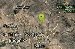
Tom's Thumb, Feldspar, and Marcus Landslide Loop
Scottsdale, Arizona
28.0 miles NEHike near Scottsdale, Arizona
Hike
Tom's Thumb Trail
Scottsdale, Arizona
28.0 miles NETom's Thumb Trail is a popular trail on the McDowell Sonoran Preserve due to its unique thumb-like granite rock formation. This is a 4.7 out-and-back, intermediate trail because of its 1,200...
Hike, Mountain Bike, Rock Climb 2.2 mi
Marcus Landslide Trail
Scottsdale, Arizona
28.1 miles NEThe Marcus Landslide Trail is named after ASU professor Melvin Marcus, a renouned geographer, after the discovery and recognition of the interesting geographical area in 2002. More than 500,000...
Hike, Horseback, Mountain Bike, Rock Climb

Pinnacle Peak Trail
Scottsdale, Arizona
28.6 miles NPinnacle Peak is a 3.5 mile out-and-back, moderate hiking trail, that includes rock climbing routes (for experienced climbers), within the Sonoran Desert. This trail, and park, in...
Hike, Horseback, Rock Climb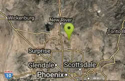
Apache Wash Trail
Phoenix, Arizona
29.1 miles NStart west on Ocitillo to Ridgeback north till you get to the crossing of Sidewinder then head west. Keep on Sidewinder toil you come to the crossing of Octillio and head east back to...
Hike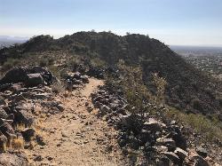
Sunrise Mountain Trail
Peoria, Arizona
29.2 miles NWThe Sunrise Mountain Trail can be found within the suburban area of Peoria, Arizona; it is made of up 3 sequential loops; each loop harder than the last. The trail is easy to find, as...
Hike, Mountain Bike
Sidewinder, Apache Vista, Ocotillo Loop Trail
Phoenix, Arizona
29.3 miles NThis is an excellent loop that is very well maintained, well sign posted and if you include the vista summit trail, a moderate work out. Massive Car Park, good restrooms, and plenty of...
Hike, Horseback, Mountain Bike
West Wing Mountain Advanced Trail
Peoria, Arizona
29.4 miles NWHike near Peoria, Arizona
Hike
Ocotillo/Ridgeback/Sidewinder Loop Trail
Phoenix, Arizona
29.4 miles NGreat moderate loop which includes a summit, great views and Classic Sonoran Desert scenery. Multiple access points and other connecting trails allows for the loop to be changed if...
Hike, Horseback, Mountain Bike
Bobcat Trail - Sonoran Preserve
Phoenix, Arizona
29.7 miles NBobcat Trail is a short, easy trail, often used for connecting to other bigger trails in the Sonoran Desert Preserve. This is a 2 mile out-and back trail. There isn't much of a parking...
Hike 4.8 mi
Lost Creek Petroglyph Trail
Buckeye, Arizona
29.8 miles WStarting at Verrado's trailhead, the trail heads a short ways to a petroglyph site. While a little rocky at times, the trail is easy. To deter vandals, a very necessary fence with barbed-wire has...
Hike, Mountain Bike
Wagner-Granite-Bluff Trails
Scottsdale, Arizona
30.2 miles NEHike and Mountain Bike near Scottsdale, Arizona
Hike, Mountain Bike
Wagner Trail
Scottsdale, Arizona
30.2 miles NEWagner Trail is a 2.2 mile, beginner to intermediate loop trail located in the McDowell Sonoran Preserve. The trail is well-marked and easy to follow; this wide, but rugged...
Hike, Horseback, Mountain Bike
Tortoise and Hilltop Trails
Fort McDowell, Arizona
30.2 miles NEBe on the lookout for wildlife like jackrabbits and lizards on the initial stretch of trail (Tortoise Trail) and for mountain bikers as this trail joins the Pemberton Trail for a bit as...
Hike
South, Bajada, Mule Deer Loop Trail
Waddell, Arizona
30.5 miles NWSouth - Bajada - Mule Deer Loop is a 4.1 mile loop trail located near Waddell, Arizona that offers the chance to see wildlife. The trail is rated as moderate and is accessible from...
Hike, Horseback, Mountain Bike


