Holter Lake Campground
Wolf Creek

Camp, Canoe, Kayak, and Swim
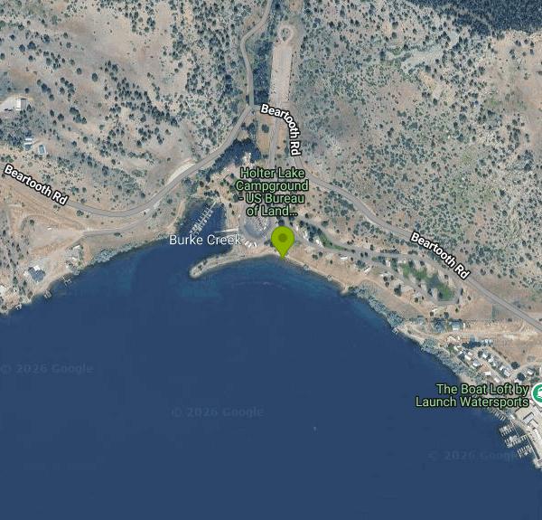
Holter Lake Campground is a Bureau of Land Management recreation site on the lower end of Holter Lake, the reservoir that Holter Dam backs up on the Missouri River in Lewis and Clark County, Montana. It is run by the BLM Butte Field Office and sits a few miles east of Wolf Creek, roughly 45 miles north of Helena. Along with the 52-site campground, the site has a day-use area with a boat ramp, docks, fishing piers, picnic shelters and a designated swimming area on the lakeshore. The lake runs about 24 miles upstream from the dam, and the cliffs of the Gates of the Mountains and the Sleeping Giant formation are within view or a short boat ride away.
From Helena, take Interstate 15 north to exit 226 at Wolf Creek and follow Recreation Road toward the river. After the steel bridge over the Missouri, turn right onto Beartooth Road and drive 2.3 miles; the entrance is on the right at 1380 Beartooth Road. Coming from Great Falls, use exit 234 at Craig and follow Recreation Road south about 5 miles, turning left onto Beartooth Road just before the bridge. Day visitors can park in a small paved lot by the campground office and host site, in a larger paved lot beside the boat ramp, or in an overflow lot across Beartooth Road. A paved path leads from the day-use parking to the docks, piers and swimming area.
The swimming area is a small beach in the day-use area near the boat docks, and visitors describe it as best suited to kids and waders. Holter is a run-of-the-river reservoir, so its level holds fairly steady through summer, but the lake averages about 50 feet deep and the water stays cool into early summer. BLM warns that weather here can change drastically. No lifeguards are mentioned in any BLM material, so swim at your own risk. Stay well away from the ramp and dock lanes, where powerboats come and go all day in summer.
Day use is not free. BLM sells a Holter Lake day-use pass for $5 per private vehicle per day, which covers the passholder and everyone in the car, and a $50 annual pass that covers all the BLM day-use sites at Holter and Hauser lakes. Holders of a Senior or Access interagency pass get a 50 percent discount. Passes are sold through Recreation.gov. Camping costs $25 per tent or RV, with up to two per site, and the 52 sites are reserved through Recreation.gov, though unreserved sites may open up on a first-come basis after 2 p.m. Stays are capped at 7 nights in a row. Fees run from about mid-May to mid-October, and after the season BLM shuts off the water and pulls the docks.
Check conditions before you go. BLM sometimes closes the campground for maintenance and points visitors to Devil's Elbow, Log Gulch or White Sandy as nearby alternatives. The agency warns that prairie rattlesnakes, bull snakes, ticks and black widow spiders live in the area, and that bears may come through, so store food properly. Clean, drain and dry any boat or paddleboard to keep invasive species out.
Besides swimming, people come here to fish from the piers, launch boats toward the Gates of the Mountains, paddle a kayak or canoe, and camp. The campground has shade from poplar and green ash trees, lots of picnic tables, potable water hydrants and reservable day-use shelters. There are no hookups and no dump station.
More Information
BLM preps Holter, Hauser recreation sites for winter | Bureau of Land Management
(BUTTE, Mont.) – The Bureau of Land Management’s Butte Field Office is preparing its Helena-area recreation sites for the change in seasons.At Holter and Hauser lakes, the BLM’s developed and undeveloped sites will be winterized to shut off water and remove boat docks. While the BLM sites at the lakes near Helena remain open to the public, most services and amenities will be shuttered for the winter in the coming weeks.The fee season for all sites ends Oct. 12. Limited camping remains at all campgrounds—except for White Sandy, which will close completely for the season. The gate at Clark’s Bay
https://www.blm.gov/press-release/blm-preps-holter-hauser-recreation-sites-winterButte Field Office | Bureau of Land Management
The Butte Field Office manages over 300,000 acres of public lands and approximately 650,000 acres of mineral estate in eight counties in southwestern Montana. These eight counties represent the rich diversity of Montana – ranging from prairie grasslands to timbered mountains.Recreational opportunities abound in this area! Developed campgrounds on Hauser and Holter Lakes near Helena provide an abundance of water-based recreation. The Big Hole River area south of Butte provides angler access to a blue-ribbon trout stream and several access points to the nearby Beaverhead-Deerlodge National
https://www.blm.gov/office/butte-field-officeChain of Lakes - Camping, Permits | Recreation.gov
Reserve camping, permits & activities at Chain of Lakes. 3 campgrounds, 7 permits. Book official reservations on Recreation.gov.
https://www.recreation.gov/gateways/10008685Chain of Lakes Recreation Site - Holter Lake Pass - Recreation.gov
Buy Chain of Lakes Recreation Site - Holter Lake Activity Pass in Chain of Lakes with Recreation.gov. Hauser and Holter Recreation Areas offer excellent recreational opportunities. Activities in the area include camping, boating (motorized and non-motorized), fi
https://www.recreation.gov/activitypass/38768606-a24a-11ec-9866-2e0eea22ffb7Holter Lake Campground - Montana | Bureau of Land Management
OverviewHolter Lake Campground is situated on the picturesque Holter Lake in west central Montana. The site is located approximately 45 miles north of Helena, Montana, along the Missouri River. The area offers stunning views of the Sleeping Giant Wilderness Study Area. Gates of the Mountains Historic Site is in close proximity of the campground, which is accessible via a watercraft. The area is overflowing with outdoor adventure opportunities. Whether you're into fishing, hunting, wildlife viewing, hiking, boating, water skiing, or all of the above, all of these activities are in close
https://www.blm.gov/visit/holter-lake-campgroundHolter Lake Campground, Chain of Lakes - Recreation.gov
Explore Holter Lake Campground in Chain of Lakes with Recreation.gov. Holter Lake Campground is situated on the picturesque Holter Lake in west central Montana. The site is located approximately 45 miles north of Helena, Montana,
https://www.recreation.gov/camping/campgrounds/261696Some Holter Lake camping reservations to go online in new year | Bureau of Land Management
(BUTTE, Mont.) – Good news for “plugged-in” campers hoping to reserve sites at the Bureau of Land Management’s Holter Lake Campground north of Helena: the Butte Field Office will be taking bookings online starting in 2020. Sites 1-33 at the popular and busy campground will be available via recreation.gov. This group of sites will be known as Loop A in the reservation system. In the past, these sites were booked on a first-come, first-served basis. Not all camping spots at Holter Lake Campground will be added to recreation.gov, though. Sites 34-42 will remain as “first-come, first-served,” with
https://www.blm.gov/press-release/some-holter-lake-camping-reservations-go-online-new-year
- Plan Ahead and Prepare
- Travel & camp on durable surfaces
- Dispose of waste properly
- Leave what you find
- Minimize campfire impacts
- Respect wildlife
- Be considerate of other visitors
Directions
From Wolf Creek
- Head southwest toward Co Rd 11 (141 ft)
- Turn right onto Co Rd 11 (5.4 mi)
- Turn left onto SD-44 W (15.0 mi)
- Turn right onto SD-37 N/
410th Ave (21.5 mi) - Turn left onto the ramp to Huron/
Plankinton (0.3 mi) - Merge onto I-90 W (308 mi)
- Take exit 23 for SD-34 W toward Whitewood (0.3 mi)
- Turn right onto SD-34 W (17.3 mi)
- Turn right onto US-85 N/
Heartland Expy/ Theodore Roosevelt Expy (2.3 mi) - Turn left onto US-212 WPassing through WyomingEntering Montana(94.2 mi)
- Turn left onto US-212 W/
Holt St Continue to follow US-212 W(64.3 mi) - At the traffic circle, continue straight to stay on US-212 W (41.7 mi)
- Merge onto I-90 W/
US-212 W/ US-87 N via the ramp to Billings (54.1 mi) - Take the exit onto I-90 W toward Billings (181 mi)
- Take exit 274 for US-287 toward Ennis/
Helena (0.3 mi) - Turn right onto US-287 N (62.2 mi)
- Merge onto I-15 N/
US-287 N via the ramp to Great Falls (34.6 mi) - Take exit 226 toward MT-434/
Wolf Creek (0.2 mi) - Turn right onto Walsh St (322 ft)
- Turn left onto Old United States Hwy 91/
Recreation Rd Continue to follow Old United States Hwy 91(3.3 mi) - Turn right onto Beartooth Rd (2.4 mi)
- Turn right (331 ft)
- Slight rightDestination will be on the right(0.1 mi)