Partridge Lake Park Beach
Fremont
Canoe, Kayak, and Swim
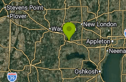
Partridge Lake Park is a small park run by the Village of Fremont on the south shore of Partridge Lake in Waupaca County, Wisconsin. Locals and birders often call it the Fremont Public Beach. The village says plainly that its large sandy beach is open to the public. Partridge Lake covers about 1,185 acres, which makes it the biggest body of water in the county, and the Wolf River runs straight through it before flowing past downtown Fremont.
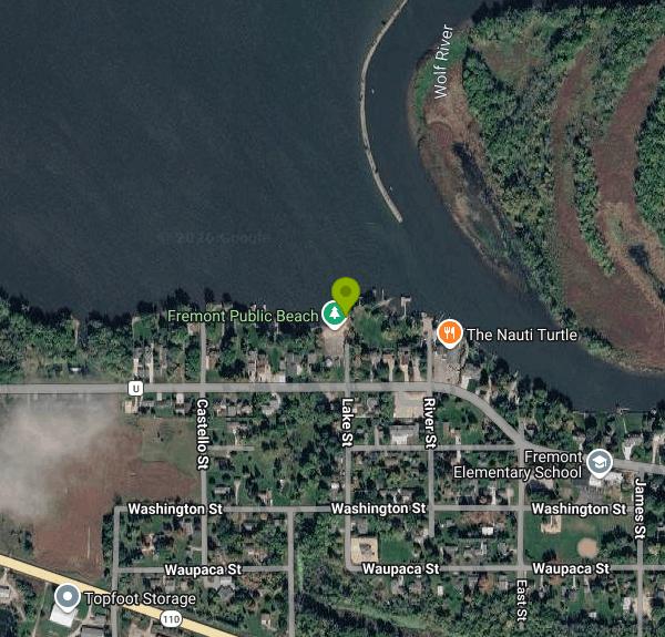
The park sits on Wolf River Drive (County Road U), roughly a mile west of downtown. From downtown, follow Wolf River Drive west along the lakeshore and turn north at Lake Street into the park. If you're coming in on Highway 110 from the west, pick up Wolf River Drive at the Old Yellowstone Highway marker and head east about a mile to Lake Street. OpenStreetMap shows a small parking area just behind the sand, and you'll find more room on the nearby village streets. It's a few steps from the car to the water, so there's no trail or hike involved.
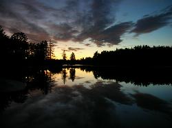
The beach is a short strip of sand facing north across open water. Partridge Lake is very shallow. The Wisconsin DNR lists a maximum depth of about 4 feet, and an older county survey put it at 6. The bottom is mostly firm sand, and the water is hard and brownish rather than clear. A lake this shallow warms up early in summer, and you can wade a long way out before it gets deep enough to swim. Nobody lifeguards the beach. The village rules are short: no lifeguard on duty, no pets, and park hours from 7:00 AM to 10:00 PM. Swimming here costs nothing. The village lists no admission or parking fee for the park, and the only fee on its parks page is the boat launch charge at its separate trailer ramps ($5 a day for a one-axle trailer, plus $1 for each extra axle).
Watch out for a few things here. Because the Wolf River flows through the lake, current and water levels can change after heavy rain upstream. In flood years the river has hit near-record levels in Fremont, with roads under water and emergency slow-no-wake orders in place. Check the village's news page before an early-season visit. The lake also gets busy with motorboats, personal watercraft and anglers in summer, so stay inside the swim area near shore. With no lifeguard, keep children within arm's reach even in shallow water.
The park has a pavilion (first come, first served, no reservations), and restrooms that open seasonally. The Wisconsin Society for Ornithology describes the beach as the closest public access to the lake and a place to launch a canoe or kayak. The best paddling is along the reedy, mostly undeveloped north shore, where you might spot terns, grebes and waterfowl. Fremont is known for its spring and fall white bass runs on the Wolf River, so you'll see plenty of anglers in town during those weeks. The village also keeps Wolf River Crossing Park and its main boat launch by the Highway 110 bridge.
More Information
Emergency Slow No Wake Lifted | Village of Fremont
Effective immediately, Waupaca County Emergencyh Managment has lifted the Emergency Slow No Wake ...
https://villageoffremontwi.gov/news-and-notices/emergency-slow-no-wake-lifted/Fremont begins cleanup as floodwater recedes, but businesses face months of hardship ahead
Some homeowners are moving sandbags and re-starting sump pumps, and local businesses are providing resources to those who need help.
https://fox11online.com/news/local/story/fremont-begins-cleanup-as-water-recedes-businesses-face-months-of-impact-after-flooding/Fremont braces for more flooding as Wolf River water moves downstream
Floodwater levels near Fremont remain at near historic levels in the Wolf River, according to an update from the Waupaca County Emergency Management posted Sunday.
https://www.wbay.com/2026/04/20/fremont-roads-still-flooded-despite-wolf-river-levels-lowering/Parks & Beach | Village of Fremont
Wolf River Crossing Park Located on the south side of Hwy 110, adjacent to the village’s main ...
https://villageoffremontwi.gov/parks-beach/Partridge Lake - Wisconsin Society for Ornithology
The Wisconsin Society for Ornithology is a volunteer, nonprofit organization established in 1939. Our mission is to promote enjoyment, study and conservation of Wisconsin’s birds.
https://wsobirds.org/haunts/haunts-waupaca/1428-partridge-lakeWater Detail - Partridge Lake, Lower Wolf River,Walla Walla and Alder Creeks Watershed (WR03)
Partridge Lake, Lower Wolf River,Walla Walla and Alder Creeks Watershed (WR03)
https://apps.dnr.wi.gov/water/waterDetail.aspx?key=18145Wisconsin Lakes
Partridge Lake is a 1185 acre lake located in Waupaca County. It has a maximum depth of 4 feet. Visitors have access to the lake from a public beach. Fish include Panfish, Largemouth Bass, Smallmouth Bass, Northern Pike, Walleye and Catfish.
https://apps.dnr.wi.gov/lakes/lakepages/LakeDetail.aspx?wbic=253800
- Plan Ahead and Prepare
- Travel & camp on durable surfaces
- Dispose of waste properly
- Leave what you find
- Minimize campfire impacts
- Respect wildlife
- Be considerate of other visitors
Directions
From Fremont
- Head southwest on Mowry Ave toward Bell St (0.2 mi)
- Turn left onto Argonaut Way (0.4 mi)
- At the traffic circle, take the 2nd exit onto Walnut AvePass by Panda Express (on the right)(0.3 mi)
- Turn right onto Fremont BlvdPass by 7-Eleven (on the left)(1.5 mi)
- Continue straight onto Washington BlvdPass by Chase Bank (on the right)(1.2 mi)
- Turn left to merge onto I-680 N toward Sacramento (13.9 mi)
- Keep left to stay on I-680 N (20.8 mi)
- Keep left to stay on I-680 N, follow signs for Martinez/
Sacramento Toll road(5.9 mi) - Keep left to continue on I-680Toll road(14.4 mi)
- Take exit 71A to merge onto CA-12 E/
I-80 E toward Fairfield/ Sacramento Continue to follow I-80 E(41.4 mi) - Take the I-80 E exit toward Reno (0.7 mi)
- Continue onto I-80 EPassing through NevadaEntering Utah(650 mi)
- Take the exit onto I-15 S/
I-80 E toward Cheyenne/ Las Vegas (3.2 mi) - Take exit 304 for I-80 E toward Cheyenne (0.6 mi)
- Continue onto I-80 EEntering Wyoming(285 mi)
- Take exit 211 for I-80BL/
WY-789 N toward US-287/ Rawlins (0.3 mi) - Turn left onto I-80BL/
WY-789 N (1.7 mi) - Turn left onto US-287 N/
WY-789 N/ 3rd St (signs for Casper-Lander) Continue to follow US-287 N/(44.1 mi)WY-789 N - Continue straight onto WY-220 E (63.6 mi)
- Turn left onto WY-257/
W Belt Lp (7.3 mi) - Continue onto US-20 E/
US-26 (2.6 mi) - Keep left to continue on US-20/
US-26 (0.4 mi) - Turn left to merge onto I-25 N/
US-87 N toward Midwest (20.5 mi) - Take exit 210 toward WY-259 N (0.3 mi)
- Turn right onto WY-259 N (17.9 mi)
- Turn right onto WY-387 E (31.7 mi)
- Turn left onto WY-50 N (51.1 mi)
- Turn right to merge onto I-90 E toward MoorcroftPassing through South Dakota, MinnesotaEntering Wisconsin(814 mi)
- Slight right to stay on I-90 E (3.6 mi)
- Take exit 48 for Co Hwy PP toward Oakdale (0.2 mi)
- Turn left onto Co Hwy PP (5.3 mi)
- Turn right onto WI-21 E (14.8 mi)
- At the traffic circle, take the 2nd exit and stay on WI-21 E (24.2 mi)
- Turn left onto County Hwy V/
County Rd V (6.9 mi) - Turn right onto County Hwy C/
County Rd C (4.7 mi) - Turn left onto County Hwy B/
County Rd B (3.0 mi) - Turn right onto County Rd O (9.4 mi)
- Turn left onto WI-22 N (2.2 mi)
- Turn right onto County Rd A (8.1 mi)
- Turn left onto County Hwy E N/
County Rd A (2.6 mi) - Turn right onto County Rd A (5.3 mi)
- Turn left onto WI-49 N (5.6 mi)
- Continue onto WI-110 S (0.8 mi)
- Turn left onto Wolf River Dr (0.7 mi)
- Turn left (226 ft)