


Sand Point
Forks, Washington

| Address: | Ozette Lake, Washington 98326, USA |
| GPS: |
48°9'13.1"N 124°40'7.2"W Maps | Directions |
| State: | Washington |
| Trails/Routes: | 5.9-9.1 mi |
Backpack and Hike
Sand Point is a beautiful stretch of wilderness beach on the remote Pacific coast of Olympic National Park, reached via the Ozette area in the far northwest corner of Washington. A destination for hikers and backpackers, it's one leg of the classic Ozette Triangle and a gateway to some of the wildest, most pristine shoreline in the Lower 48.
From the Ozette Ranger Station, a roughly 3-mile cedar-boardwalk trail winds through coastal forest and bog to emerge at Sand Point, where a broad sandy beach meets crashing surf, offshore sea stacks, and tide pools full of life. Many visitors continue north along the beach to Cape Alava and back to complete the 9-mile Ozette Triangle loop; between the two points, the Wedding Rocks hold a remarkable collection of ancient Native American petroglyphs. Wildlife is everywhere here — look for bald eagles, sea otters, seals, and, offshore in season, migrating whales.
Sand Point is a favorite for coastal backpacking, with wilderness camping on the beach. Overnight trips require a wilderness permit and a bear canister (available from the park), and campfires and food storage are regulated to protect this fragile place.
Tides are the key safety factor here. Long stretches of beach are impassable at high tide, so carry a current tide table and a map, and time your beach walking for lower tides. Come prepared for classic Olympic-coast weather — expect rain, wind, and mud any time of year — with waterproof gear and sturdy footwear. Pack out all trash, respect the petroglyphs (look, don't touch), and enjoy one of the great wild beaches of the Pacific Northwest.
More Information
File:NPS olympic-ozette-map.gif - Wikimedia Commons
From Wikimedia Commons, the free media repository
https://commons.wikimedia.org/wiki/File:NPS_olympic-ozette-map.gifSand Point
A beautiful hike through an interesting forest, often over boardwalks, ends at the beach with the potential for birdwatching and wildlife viewing. If you plan ahead and get a permit, it’s a nice overnight destination.
https://www.wta.org/go-hiking/hikes/sand-pointBe courteous, informed, and prepared. Read trailhead guidelines, stay on the trail, and don't feed the wildlife.
Read More- Plan Ahead and Prepare
- Travel & camp on durable surfaces
- Dispose of waste properly
- Leave what you find
- Minimize campfire impacts
- Respect wildlife
- Be considerate of other visitors
Directions
From Forks, Washington
- Head north on US-101 N/S Forks Ave toward E Division StContinue to follow US-101 NPass by Subway Restaurants (on the left in 0.5 mi)(12.3 mi)
- Turn left onto WA-113 N (10.0 mi)
- Continue onto WA-112 W (10.5 mi)
- Turn left onto Hoko Ozette Rd/Ozette Lake RdContinue to follow Hoko Ozette Rd(21.2 mi)


Other Hiking Trails and Backpacking Trails Nearby

Cape Alava
Forks, Washington
0.0 miles WA dual-experience loop at Olympic National Park's wild coast — a boardwalk forest stroll and an ocean beach walk combined, with wildlife refuges just offshore.
Backpack, Hike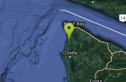
Shi Shi beach
Clallam Bay, Washington
8.3 miles NRevered by generations of hikers and naturalists, Shi Shi Beach is consistently rated one of the most beautiful beaches in the Northwest.
Camp, Hike


