


30.5K Summit 2017 by endovereric
first prev 1 next last
Alaska Basin
Driggs, Idaho
10.0 miles E of Driggs, IdahoThe Alaska Basin Trail is a stunning trail through the Jedediah Wilderness near Driggs, Idaho and goes East into Wyoming, just outside of Grand Teton National Park. The trail is wide and has easy terrain for the feet, but it is long, so it's best suited for intermediate to advanced hikers. There are spots on the trail where river crossing is necessary, so be prepared to rock hop, cross logs, or just get your feet wet.
Because the trail is in a wilderness area, rather than a National Park, no overnight camping permits are required; however, open fires are not allowed, so plan on bringing a camping stove. Carry bear spray and, if you are camping, plan on bear proofing your food and waste.
The trail features a variety of landscapes such as lush vegetation and wildflowers (peak season is July to August), rushing rivers and streams, the majestic Teton Mountain Range, and of course, the serene Alaska Basin. There is plenty of wildlife; black bears and moose both have been spotted on the trail. Enjoy their beauty, but please use precaution and respect their territory.

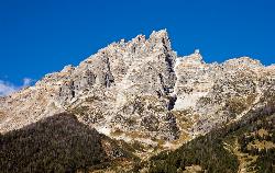
Table Rock / Table Mountain
Driggs, Idaho
10.0 miles E of Driggs, IdahoAt 11,300 feet, Table Mountain is possibly the most beautiful climb this side of the Tetons and offers what may well be the very best view of the Grand Tetons. It's just far enough away to be able to see all three peaks and close enough to make out all the detail.
There are 2 main trails with different distances but either way, you've got to climb over 4000 feet.
The Face trail is much steeper but also much shorter. It cuts out all of the switchbacks and 'B' lines it for the top. It's considerably shorter and you don't have to go very far before the view begins to open up and you can see the beauty of Teton Canyon and its surrounding peaks. (about 3.5 miles one way)
Huckleberry trail is much longer but also a much more gradual incline/decline. The trail follows and crosses North Fork Teton Creek making it a great spot to get a filtered water refill.It's not known as huckleberry for nothing. You just have to catch it at the right time (Mid-Late Summer depending on weather) and get to the bushes before everybody else picks them clean. (about 6.5 miles one way)
Check conditions via webcam at tetoncam.com.
Elevation: 11,300ft
Elevation Gain: 4000ft
Length: 7-13 miles
Teewinot Mountain
Jackson Hole, Wyoming
17.7 miles N of Jackson Hole, Wyoming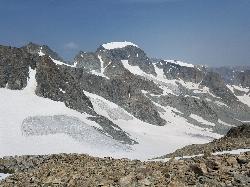
Gannett Peak
Gannett Peak, Wyoming 82513, USA
At 13,308 feet in elevation, Gannett Peak is considered to be one of the most difficult state highpoints, rivaled only by Alaska's Denali, Washington's Mount Rainier, and Montana's Granite Peak which have a range of difficulties based on weather and conditions of the climb.
July to August are considered to be the best times to go. If you try too early in the season, all the streams and lakes are still frozen over. If you go too late, then snow and bad weather is more common which makes more a much more strenuous hike. The downside to going in July and August is that the Wind Rivers are renowned for horrendous swarms of voracious mosquitoes. Many climbing parties prefer visiting during July when the Gooseneck Glacier bergschrund (and other crevasses) are not yet fully opened (if at all). Snowpack can actually make a summit attempt less strenuous than travelling on ice and/or rock for long distances.
There are three major trails to the top:
- Pole Creek Trail to Titcomb Basin
This is a 40 mile round trip with approximately 9050 feet cumulative elevation gain. This route has long been considered the main standard approach for Gannett Peak, although the Glacier Trail approach from the east has been gaining popularity during recent years. This western approach is a well-travelled route full of spectacular scenery and views. - Glacier Trail
This trail is a 50 mile round trip from the Dubois side and has a cumulative elevation gain of 10,750 feet. The biggest advantage to this route is it puts you at a higher camp for your summit day giving you a better chance of success and less strenuous terrain than the standard western approach. - Ink Wells Trail
The advantage of this route is that a large amount of distance and effort can be saved by the time the route intersects with the Glacier Trail. However, the disadvantage of this route is that access is both limited and expensive. This route crosses the Wind River Indian Reservation, which requires special permission, guidance, and transportation to travel through. Reservations are required in advance and sometimes difficult to achieve, and even if a reservation can be made, the cost can be substantial.


