


4 locations
Add Location
 Full Listing
Show more
Dive, Swim
Last visited on 4 Jul 2017
Full Listing
Show more
Dive, Swim
Last visited on 4 Jul 2017
 Full Listing
Show more
Dive, Swim
Last visited on 25 Aug 2016
Full Listing
Show more
Dive, Swim
Last visited on 25 Aug 2016
 Full Listing
Show more
Dive, Swim
Last visited on 25 Jul 2016
Full Listing
Show more
Dive, Swim
Last visited on 25 Jul 2016
0.2-0.5 mi
 Full Listing
Show more
Camp, Hike, Mountain Bike, Sled
Last visited on 25 Jul 2017
Full Listing
Show more
Camp, Hike, Mountain Bike, Sled
Last visited on 25 Jul 2017
Eagle Park
Rexburg, Idaho
0.9 miles N of Rexburg, IdahoEagle Park is a little urban oasis. Once you drive in to this cottonwood forest along the river, you may forget that you're still inside Rexburg city limits. You can camp, picnic, throw rocks in the river, fish, mountain bike, or just go for a walk along the trail or road. All sites have picnic tables, fire rings, and tent pads. Just off the main parking lot is a nicely mowed grassy area that is a popular dog park. On the West end of the parking lot, you'll find a multi-use trail that will take you almost the entire length of the park.
Mountain Biking/Hiking/Walking
The trail system at Eagle Park is maintained in part by Free Arenas. If you have any would like to get involved or just want to share your thoughts on how to improve it, email trailbuilding@freearenas.com.
Tenderfoot is primarily a mountain bike trail. The trail runs back behind most of the campsites. While it's built for mountain bikes, it's usually great for a nice quiet walk as well, and arguably the best way to see the park. This 0.5 mile trail is rated Easy but is about as tough as an easy trail can get. It's pretty mellow but does have a couple of very short ups.
Taut-line is cut into the slope along the fence line. It begins on the embankment at the West end of the campground and goes for 0.4 miles before meeting back up with Tenderfoot. The Northwest section is the longest section of trail in Eagle Park and is cut into a steep slope above marsh and ponds. It is generally downhill from the West end but has plenty of up and down. Towards the middle of the trail, there is a berm and a couple of table top jumps. The section South of the Tenderfoot junction was an Eagle Project completed by Ian Hoffman and his volunteer crew. The trail continues to cut up and down the side hill with a fun rock berm and a rock garden. The end drops in to connect back to Tenderfoot right near the junction with Bugler. The trail is a one-way trail from West to East and has short climbs and fun decents. Because it's much higher than the Tenderfoot Trail it parallels, Taut-line does not flood and actually bypasses the flood areas of Tenderfoot. Because the trail does go along a steep slope on the West end, remember to fall uphill. This trail is rated Intermediate.
Bugler drops off the Tenderfoot Trail and runs down and around a small pond just off the main lawn. There's a few decents, climbs, and berms adding a little bit of speed and a little more difficulty.
Jamboree drops off the Eagle Park Road near campsite 19 and continues down along the river to the old campsite 14 that's now a disc golf basket. This trail rolls back and forth through a trough of sorts with some jumps along the edges and potential for many more. It seeps ground water when the water is higher and is completely flooded in May/June when the river is really high. When it's dry though, it rides decently fast and is a lot of fun!
Skills Park Along the Tenderfoot Trail and just off the lawn is a skills park built as an Eagle Scout project by Erik Hurst and other volunteers. It features a large wrap-around berm on the north end, raised skinnies made of 2x8, 2x6, and 2x4 treated lumber, a ladder a-frame, a rock garden, and a see-saw.
While not all trails are intended to bi-directional and multi-use, they are all used as such so please be aware of others on the trail.
Looking for a little longer hike or ride? Go to the Northwest end of the park and you'll find an old embankment road that follows the airport fence line to the Nature Park. It's pretty popular to loop both parks together.
Sledding
There's some mounds above a bench that can be used as a sledding hill area just off the main grassy area. It's a terraced hill with a couple set runs and then quite a bit of open hill as well. Elevation is only about 20 feet from top to bottom but there's plenty to keep kids busy for awhile. There's even a more difficult run that includes jumps and drops for snowboards. The terrace trails are better when the snow's a little bit icier but the small hills are great for little kids that wnat to avoid the more popular hill at Smith Park
Camping
Picnicking is free but there is a fee for camping. Overnight camping fee is $10.00 per space paid via rexburg.org. All fees are used for future picnic tables, restrooms and other park improvements. The camp fee for boy scout troops may be waived as long as they perform an approved 1 hour service project to the park while camped here. Picking up garbage and pulling weeds are always approved. Weeds that need pulled include hounds tongue, cocklebur, bull thistle, and the occasional stinging nettle.
Posted Eagle Park Rules
- No RVs in park
- No motorcycles, scooters, or ATVs on park roads
- 7 day camping limit
- Tents only on designated tenting pads
- Fires in designated fire pits only. No non-burnable items in firepits.
- No smoking, tobacco, or alcoholic beverages
- Pets on leashes only. (All pet droppings to be put in bags for droppings)
- All garbage to be put in garbage cans. Pack it in - Pack it out.
- No firearms, firecrackers, or explosives
- Avoid loud music and noises — Be respectful of other campers
To reserve an entire shelter, call City Hall at 359-3020. Reservation fee is $25 per half day.
This is a community service project of Free Arenas, the Madison Lions Club, Trails of Madison County, the City of Rexburg, and numerous Eagle Scouts in the Yellowstone District of the Grand Teton Council, BSA. Constructed 2001-2005.
Please respect the flora and fauna and practice the Outdoor Code. This park only exists because of volunteer service from many in the community. Please, don't be afraid to help out by collecting some hounds tongue, cocklebur, and bull thistle. If you're looking for ideas for a bigger service project, contact trailbuilding@freearenas.com
Twin Bridges
St. Anthony, Idaho
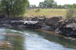
6.6 miles NE of St. Anthony, IdahoTwin Bridges is a beloved bridge-jumping and swimming spot on the river near St. Anthony, Idaho — a summer institution for families, teens, and college students across the upper Snake River Valley. The name comes from the setup: an old abandoned bridge stands right beside the one still in use, and the deep, slow water beneath the old span makes for about the best bridge jumping around, with no traffic to dodge and easy parking nearby.
The jumping is the main event, and it's well suited to a range of nerve. There are two distinct levels to leap from — a lower point around 11 feet and a higher one around 17 feet — so you can start small and work your way up, and the water below is plenty deep for cannonballs, flips, and gainers. Locals consider it about as good and as “reasonably safe” as bridge jumping gets, with one firm caveat: keep clear of the rocks along the sides, which can be exposed depending on the water level.
There's more to it than jumping. A little rope swing often hangs under the bridge — a favorite of the little kids — and a path up the river makes a good put-in for a short, mellow float back down. For families with young children, there's a sandbar on the north side just upstream of the action, perfect for wading and splashing away from the jumpers. The slow current is ideal for simply hanging out in the water while you watch your friends show off.
A fun local curiosity: downstream of the little rock dam on the north side lie the sunken remains of an old car, washed here after an accident years ago. When the water is low and clear you can spot its chrome bumper from the rocks and swim down for a look — a quirky bit of underwater sightseeing that regulars love.
Part of the appeal is how welcoming and community-minded the spot is. Generations of upper-valley families and Rexburg-area college students have made Twin Bridges their go-to summer swimming hole, and there's a friendly, everybody-shares-the-water vibe on a busy afternoon. It's the kind of simple, free, small-town summer pleasure that keeps people coming back week after week.
A few practical notes: it's a popular place, so expect a crowd on hot, sunny days and holidays — though it handles a lot of people well, and you rarely wait long to jump. Bring water shoes for the rocky spots, sun protection, and drinking water, always check the water depth and clear your landing before jumping (levels change through the season), keep an eye on kids near the current, and pack out all your trash. For a classic, easygoing eastern-Idaho swimming hole, Twin Bridges is hard to beat.
Fall River Bridge
Ashton, Idaho
6.6 miles SW of Ashton, IdahoRight off Highway 20, there's a great spot to swim, swing, and dive. There's pullouts for parking right next to the bridge. There's a rope swing under the railroad bridge and a little swimming hole to the North. As always be careful of water levels. There are rocks down the middle of the river on the North side. If they're covered, the water is high.
Hog Hollow Bridge
Saint Anthony, Idaho
4.3 miles SE of Saint Anthony, IdahoLess than 1/2 a mile down the road from the Monkey Rock waterfall, Hog Hollow Bridge is a favorite spot for adrenaline junkies to cool off. The place to jump is off the East side of the bridge where it's deeper. It's about a 25 foot jump, depending on the water level. Always be careful of fast moving water, as well as rocks and debris below the surface.
CAUTION: This jump is from an active roadway so please be careful and considerate of drivers. They do have the right of way on the bridge and the road is often traveled by large trucks who will have difficulty stopping for a swimmer that decides to run out in front of them while they're crossing a bridge.
PLEASE NOTE: Ton the roads leading to the Hog Hollow Bridge, the speed limit is 35 mph for the last mile. There are kids, cows, horses, and dogs along that road and many people tend to speed going to and from Monkey Rock. Slow down and stay safe.
×


