


28 Bucket List by jssouthworth
first prev 1 next last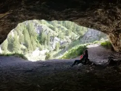
40 Horse Cave
Firth, Idaho
11.9 miles E of Firth, Idaho40 Horse Cave is a fun, family-friendly cave tucked into the rocky walls of Wolverine Canyon, on public BLM land about 15 miles from Firth, Idaho. It's reached by a scenic drive up well-maintained Wolverine Road, with a parking area a couple of miles into the canyon, and there are no fees. The cave gets its colorful name from a pair of local legends — one tells of two men caught in a storm who ducked inside, one remarking that “this cave could hold about 40 horses”; another claims a thief once stashed 40 stolen horses here to avoid capture. Either way, the roomy opening makes the tall tale easy to believe.
The hike up to the cave is short but steep — only about 500 feet long with roughly 100 feet of climbing, yet it earns every step. There are two ways up: the shorter, more direct route is a loose shale scramble that's genuinely slippery (hikers and kids alike tend to slide around, even in good boots), while the slightly longer trail is still steep but holds much less shale and makes for a far easier descent. A common strategy is to grind up the short shale route and come down the gentler one.
Inside, the cave runs only about 25 to 50 feet deep, so a flashlight isn't strictly required — but a few nooks and back corners are more fun to poke around with a light, and kids can easily spend half an hour or more exploring. Keep an eye out for the rock chucks (yellow-bellied marmots) that sun themselves on the boulders around the canyon.
There's more to discover nearby. At the bottom of the trail, a culvert near the road becomes a fun place to splash around when the creek is running high. And if you follow the faint trail in the willows on the southeast side of the road for about 100 feet of easy walking, you'll find a smaller second cave worth a look.
Wolverine Canyon itself is worth the trip. Its rugged rock walls draw rock climbers, the creek and cottonwoods make for pleasant camping and picnicking, and the quiet canyon is good for wildlife watching — deer, raptors, and those ever-present marmots. Many families make a half-day of it, combining the cave with a creekside lunch and a wander among the canyon's formations.
A few practical notes: Wolverine Road is usually in good shape, but it can occasionally be closed to vehicle traffic, so it's worth checking conditions before a long drive. The canyon is a shared landscape of public land and working ranches, so respect any private property and livestock you encounter, leave gates as you find them, and pack out your trash. Bring water, sturdy shoes with good grip for the shale, and sun protection, and enjoy one of eastern Idaho's most enjoyable little cave adventures.
Firth River Bottoms
Firth, Idaho
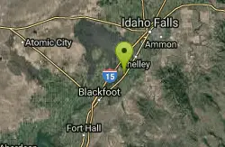
0.7 miles W of Firth, IdahoThe Firth river bottoms are the broad, cottonwood-lined lowlands where the Snake River winds past the small farming town of Firth in eastern Idaho, a stretch of quiet water, gravel bars and shady bank that has long served as a local playground between Idaho Falls and Blackfoot. This isn't a manicured park; it's working river country, where families come to fish, float, wade and cool off on a hot summer afternoon in the shade of the big cottonwoods. For locals it's simply where you go when you want the river.
Public access is the practical key here, and Idaho Fish and Game maintains two access sites right in town: the Firth Bridge access and the Firth City Park access, both providing parking and a way down to the water for anglers, floaters and swimmers. From Firth, the river runs about seven miles downstream to the Rose bridge, a well-known float and fishing stretch that makes for an easy half-day on the water with a shuttle set up at either end.
The fishing is genuinely good and pleasantly varied. This reach of the main Snake holds rainbow and brown trout along with smallmouth bass and an abundant carp population, so it rewards fly anglers, spin fishermen and kids with a worm alike. Local wisdom favors streamers for big browns in March and April and again in the fall, while summer brings warm, mellow water better suited to bass, carp and swimming than to trophy hunting. An Idaho fishing license is required.
The bottoms also draw waterfowl and wildlife into the cottonwood galleries and side channels, making for good, low-key birdwatching, and the flat riverside ground is pleasant for a walk or a picnic. It's an unpretentious, local kind of place rather than a destination with facilities and signage, which is a good part of its charm.
The Snake is a big river here, with current that runs stronger than its calm surface suggests, and levels swing substantially with irrigation demand and season, changing gravel bars and depths from one visit to the next. Spring runoff brings high, cold, pushy water; late summer settles into the friendliest conditions for wading and swimming. Much of the surrounding bottomland is private farm ground, so sticking to the public access sites and the river itself keeps everyone on good terms.
Come with water shoes for the rocky bottom, sun protection for the open river, insect repellent for the cottonwood shade, and a trash bag. Whether you're floating down to Rose, chasing browns at dusk, or just wading in on a July afternoon, the Firth bottoms are an honest, easygoing slice of the eastern Idaho Snake.
The Playground
Shelley, Idaho
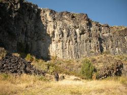
9.1 miles SE of Shelley, IdahoThe Playground is a fun, moderate to hard place to sport rock climb. You can find approximately nine routes (popular ones include: Tied to the Whipping Post, Cure for the Hangover, Anchored to the Sky) on this basalt type rock, ranging from 70 - 80 feet in height. The prime time to climb would be the warmer months from April - September. The Playground is located outside of Idaho Falls, east of the small town of Firth.


