


40 Horse Cave
Firth, Idaho
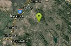
| Address: | Wolverine Rd, Firth, ID 83236, USA |
| GPS: |
43°16'53.6"N 111°56'54.7"W Maps | Directions |
| State: | Idaho |
| Trail Length: | 0.18 miles |
| Trail Type: | Out & Back |
| Hike Difficulty: | Intermediate |
| Trails/Routes: | 0.1 mi |
Cave and Hike
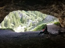
40 Horse Cave is a fun, family-friendly cave tucked into the rocky walls of Wolverine Canyon, on public BLM land about 15 miles from Firth, Idaho. It's reached by a scenic drive up well-maintained Wolverine Road, with a parking area a couple of miles into the canyon, and there are no fees. The cave gets its colorful name from a pair of local legends — one tells of two men caught in a storm who ducked inside, one remarking that “this cave could hold about 40 horses”; another claims a thief once stashed 40 stolen horses here to avoid capture. Either way, the roomy opening makes the tall tale easy to believe.
The hike up to the cave is short but steep — only about 500 feet long with roughly 100 feet of climbing, yet it earns every step. There are two ways up: the shorter, more direct route is a loose shale scramble that's genuinely slippery (hikers and kids alike tend to slide around, even in good boots), while the slightly longer trail is still steep but holds much less shale and makes for a far easier descent. A common strategy is to grind up the short shale route and come down the gentler one.
Inside, the cave runs only about 25 to 50 feet deep, so a flashlight isn't strictly required — but a few nooks and back corners are more fun to poke around with a light, and kids can easily spend half an hour or more exploring. Keep an eye out for the rock chucks (yellow-bellied marmots) that sun themselves on the boulders around the canyon.
There's more to discover nearby. At the bottom of the trail, a culvert near the road becomes a fun place to splash around when the creek is running high. And if you follow the faint trail in the willows on the southeast side of the road for about 100 feet of easy walking, you'll find a smaller second cave worth a look.
Wolverine Canyon itself is worth the trip. Its rugged rock walls draw rock climbers, the creek and cottonwoods make for pleasant camping and picnicking, and the quiet canyon is good for wildlife watching — deer, raptors, and those ever-present marmots. Many families make a half-day of it, combining the cave with a creekside lunch and a wander among the canyon's formations.
A few practical notes: Wolverine Road is usually in good shape, but it can occasionally be closed to vehicle traffic, so it's worth checking conditions before a long drive. The canyon is a shared landscape of public land and working ranches, so respect any private property and livestock you encounter, leave gates as you find them, and pack out your trash. Bring water, sturdy shoes with good grip for the shale, and sun protection, and enjoy one of eastern Idaho's most enjoyable little cave adventures.
More Information
40 Horse Cave - RexburgFun
There are plenty of great things to do in and around Rexburg! A description and directions on how to get to 40 Horse Cave, located near Rexburg, Idaho.
https://rexburgfun.com/40-horse-cave/Wolverine Canyon - Idaho | Bureau of Land Management
Wolverine Canyon has opportunities for dispersed camping, snowmobiling, rock climbing and mountain biking & hiking. Opportunities are also available for wildlife viewing - If you’re lucky, you may see a Bald Eagle flying above the canyon.
https://www.blm.gov/visit/wolverine-canyonBe courteous, informed, and prepared. Read trailhead guidelines, stay on the trail, and don't feed the wildlife.
Read More- Plan Ahead and Prepare
- Travel & camp on durable surfaces
- Dispose of waste properly
- Leave what you find
- Minimize campfire impacts
- Respect wildlife
- Be considerate of other visitors
Directions
From Firth, Idaho
- Head southwest on US-91 S/
Main St toward W Center St Continue to follow US-91 S(0.4 mi) - Turn left onto N 550 E/
Idaho Rd (1.2 mi) - Turn left onto E 600 N/
Wolverine Rd Continue to follow Wolverine RdDestination will be on the left(13.9 mi)
Take Wolverine Road up into Wolverine Canyon. Once you enter the canyon, it's 2.6 miles to the parking lot. You'll see a road/pullout to the left after 2 miles. When you near the cave, you'll be able to see it up the hill on your left as you go over a culvert where the creek goes under the road. The trailheads are by the culvert and the parking lot is on the left just around the bend.
Shelby
2/1/23 9:09 pmBrenda Denney
4/20/21 1:00 pmendovereric
4/21/21 9:05 am


Other Hiking Trails and Caves Nearby

Firth River Bottoms
Firth, Idaho
12.6 miles WA community riverside park in Firth with horseback riding, picnicking, fishing, and baseball — something for the whole family along the river bottoms.
Camp, Canoe, Hike 1.0-7.5 mi
Idaho Falls Greenbelt
Idaho Falls, Idaho
15.6 miles NA 6-mile paved riverside trail through the heart of Idaho Falls past a 22-foot waterfall that stretches 600 feet wide, historic landmarks, parks, and downtown restaurants.
Hike
Hell's Half Acre Northbound Rest Stop
Blackfoot, Idaho
16.2 miles WA well-kept I-15 rest area near Blackfoot features lava-flow interpretive signs, walking paths, picnic tables, and vending machines — a worthwhile stop on any road trip.
Hike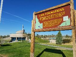
Hell's Half Acre Southbound Rest Stop
Blackfoot, Idaho
16.2 miles WA well-maintained Interstate 15 rest stop on a lava flow area with a great walking path, informational signs about the formations and wildlife, picnic tables, and vending machines.
Hike
Blackfoot, ID 83221, United States
Blackfoot, Idaho
20.9 miles WHike and Mountain Bike near Blackfoot, Idaho
Hike, Mountain Bike
17 Mile Cave
Idaho Falls, Idaho
27.2 miles NWA lava tube just 17 miles from Idaho Falls with a nearly flat quarter-mile tunnel ending in two cool pools — easy for beginners, though expect graffiti on the walls.
Cave, Hike 3.8 mi
Stinking Springs
Ririe, Idaho
27.2 miles NEAn ATV and dirt bike trail that doubles as a mountain bike gem — progressively bermed switchbacks, rock rolls, and gardens lead to connections with Kelly Canyon and the broader Big Hole range.
Hike, Mountain Bike 0.3-0.6 mi
Cress Creek Nature Trail
Rexburg, Idaho
28.5 miles NEA 1.25-mile self-guided nature trail along the South Fork of the Snake River through sagebrush, juniper slopes, and lush creekside habitat — with an overlook trail, caves near the rim, and moose sightings.
Hike 3.8 mi
Kelly Mountain Trail
Ririe, Idaho
29.9 miles NEA moderate uphill trail open to hikers, mountain bikers, and ATVs, winding through hills with wildflower and mountain views — dogs welcome on leash.
Cross-country Ski, Hike, Mountain Bike, Snowshoe
Poison Flats
Ririe, Idaho
30.1 miles NEHike near Ririe, Idaho
Hike 1.1 mi
Hidden Vista / Pine Loop
Ririe, Idaho
30.6 miles NEA short singletrack trail to a canyon overlook with Snake River views — then a detour east for fun climbs, turns, rocks, and jumps on the way back to the Buckskin Morgan parking lot.
Hike, Mountain Bike 1.7 mi
Buckskin Morgan Ridge
Ririe, Idaho
30.6 miles NEA punchy climb to Buckskin Morgan Ridge pays off with twisty singletrack descents through roots, loose rock, and rolling hills above the Snake River Plain.
Hike, Mountain Bike
Fall Creek Falls
Swan Valley, Idaho
30.7 miles EA shaded Snake River campground near Swan Valley with abundant wildlife, great trout fishing, and Fall Creek Falls a quarter-mile away.
Camp, Cave, Hike, Kayak, Swim 0.9 mi
Hell's Half Acre Lava Walk
Blackfoot, Idaho
31.1 miles NWTwo lava trails — a quick half-mile loop or a 4.5-mile route to the main vent — trace a 4,100-year-old 222-square-mile eruption across the Snake River Plain.
Hike 1.0-1.3 mi
Lorenzo Bridge
Rexburg, Idaho
31.5 miles NA quiet former boat launch with primitive riverside trails, a hidden lake, stunning fall colors, and a natural paintball field bounded by river and dry creek bed.
Airsoft, Hike, Paintball
Lorenzo Boat Ramp
Rigby, Idaho
31.6 miles NHike and Kayak near Rigby, Idaho
Hike, Kayak 0.6-2.2 mi
Fish Creek Area
Ririe, Idaho
32.5 miles NEThe Big Hole Mountains' Fish Creek trail network serves up singletrack climbs, floater jumps, rock gardens, and fast Fishbone descents accessed from Ririe or Rexburg.
Hike, Mountain Bike
Burns Canyon
Ririe, Idaho
32.8 miles NEHike and Mountain Bike near Ririe, Idaho
Hike, Mountain Bike
Herbert Idaho Ghost Town
Ririe, Idaho
32.8 miles NECLOSED. Private property marked NO TRESPASSING. The quiet ghost of a farming and mining community that once housed 150 people — Herbert, Idaho faded with the automobile, and the old house was lost to vandals around 2017.
Hike 0.5-3.5 mi
Webster's Dam
Ririe, Idaho
33.6 miles NEAn abandoned dam in Moody Creek canyon where sediment split the stream into two beautiful 15-foot waterfalls — stunning in spring runoff and blazing with fall colors.
Camp, Hike, Mountain BikeNearby Campsites
Blackfoot River Crossing at Trail Creek Road
Firth, Idaho
10.5 miles SA remote Blackfoot River crossing accessed via a network of gravel roads near Firth, Idaho — multiple parking areas along a wildlife management area stretch of the river.
Camp
Firth River Bottoms
Firth, Idaho
12.6 miles WA community riverside park in Firth with horseback riding, picnicking, fishing, and baseball — something for the whole family along the river bottoms.
Camp, Canoe, Hike
Sealander Park
Idaho Falls, Idaho
15.5 miles NWA peaceful 15-acre park steeped in Idaho homesteader history — listed on the National Register of Historic Places, Sealander Park is available to reserve for picnics, reunions, weddings, and retreats.
Camp
Kelly Island Campground
Ririe, Idaho
27.6 miles NEA BLM campground with 14 family sites and 1 group site for RVs or tents, open May through September — vault toilets, pets welcome, and rates from $5–$20 per night.
Camp
Wolf Flats Recreation Area
Ririe, Idaho
27.7 miles NEWolf Flats is a completely free, dispersed, undeveloped camping area with 25 locations to camp. Some areas are large enough to accommodate groups of 50 people.
Camp
Twin Bridges Park
Rexburg, Idaho
28.5 miles NA 27-acre Snake River park between two bridges near Rexburg with shaded campsites, fire pits, pavilions, a playground, and BLM ground for hiking and hunting on three sides.
Camp, Canoe
Paramount Wall / Blanche Rock
Ririe, Idaho
28.8 miles NEA sport climbing wall above the road near Ririe with great exposure, afternoon shade, and well-loved 5.9–5.10 lines — most routes work with a 50-meter rope, established by Chuck Oddette and crew.
Camp, Horseback, Rock Climb
Jefferson County Lake (AKA Rigby Lake)
Rigby, Idaho
29.0 miles NSandy beaches, two floating docks with a slide, volleyball, playgrounds, and a safe swim zone — Jefferson County Lake is eastern Idaho's go-to summer swimming spot.
Camp, Canoe, Dive, Kayak, Sled, Swim
Table Rock Campground
Ririe, Idaho
30.1 miles NEA campground in Caribou-Targhee National Forest — part of a 3-million-acre stretch from Montana to the Utah and Wyoming borders — with access to the Curlew National Grassland.
Camp
Fall Creek Falls
Swan Valley, Idaho
30.7 miles EA shaded Snake River campground near Swan Valley with abundant wildlife, great trout fishing, and Fall Creek Falls a quarter-mile away.
Camp, Cave, Hike, Kayak, Swim
Falls Campground
Victor, Idaho
31.2 miles EA Snake River campground near Swan Valley with cottonwood shade, abundant wildlife — eagles, osprey, moose, and deer — and Fall Creek Falls just a quarter mile away; Palisades Reservoir is 20 miles out.
Camp
Big Hole Dispersed Campsites
Ririe, Idaho
32.0 miles NEA network of dispersed campsites with fire rings in the Big Hole mountains above Kelly Canyon — first come, first served, no reservations, and Leave No Trace principles are essential.
Camp 0.5-3.5 mi
Webster's Dam
Ririe, Idaho
33.6 miles NEAn abandoned dam in Moody Creek canyon where sediment split the stream into two beautiful 15-foot waterfalls — stunning in spring runoff and blazing with fall colors.
Camp, Hike, Mountain Bike 0.6-2.0 mi
North Menan Butte ('R' Mountain)
Menan, Idaho
34.9 miles NA volcanic butte locals call R Mountain, with a paved trailhead, chain handrails near the top, informational signs at the rim, and views of Rexburg and the Snake River.
Camp, Cave, Hike 6.6-6.8 mi
Bear Creek Hot Springs
Irwin, Idaho
36.0 miles ETrek ~13 miles up a creek canyon near Palisades Reservoir to a secluded natural hot spring — gentle most of the way, with one rewarding final climb.
Backpack, Camp, Hike, Horseback, Hot Springs, Mountain Bike
Moody Meadows
Driggs, Idaho
36.7 miles NEGood place for kids, they can ride bikes in the meadow, play in the stream, and camping is off of the road. Hiking, motorbiking, and horseback riding trails are abundant in the area.
Camp
Calamity Campground
Irwin, Idaho
37.1 miles EA wooded Palisades Reservoir campground 55 miles east of Idaho Falls with clean blue water for swimming, boating, water skiing, and fishing — plus miles of ATV routes.
Camp, Canoe, Hike, Kayak, Mountain Bike, Swim
Beaver Dick Park
Rexburg, Idaho
37.6 miles NA 9.5-acre Snake River park near Rexburg with fire pits, pavilions, fishing, boating, swimming, and a rich history tied to legendary frontiersman Beaver Dick Leigh.
Camp, Canoe, Disc Golf, Swim 2.8-4.1 mi
Palisades Creek Trail / Lakes and Waterfall Canyon
Irwin, Idaho
37.8 miles ESpectacular mountain views, two landslide-formed alpine lakes, and mountain goat sightings — all within a 4-to-6-mile hike in the Swan Valley wilderness.
Backpack, Camp, Hike, Horseback, Mountain Bike 0.2-0.5 mi
Eagle Park
Rexburg, Idaho
39.0 miles NA cottonwood forest park inside Rexburg city limits with campsites, fishing, a dog park, mountain biking on easy and moderate loops, and rock-throwing by the river.
Camp, Hike, Mountain Bike, Sled


