


5 arizona by nawwal120
first prev 1 next last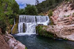
Fossil Creek Dam (Toilet Bowl)
Pine, Arizona
6.6 miles W of Pine, ArizonaHidden in the high desert between Pine and Camp Verde, Fossil Creek is one of Arizona's two federally designated Wild and Scenic rivers — a spring-fed, travertine-blue oasis that pours some 20,000 gallons a minute out of the ground and brings its canyon vividly to life. Along its course lie several beloved swimming and hiking destinations, including two waterfalls; this one, the “Toilet Bowl,” is the swimming hole at the old Fossil Creek dam.
Despite the unglamorous nickname, it's a gorgeous spot. The name comes from a round, natural chute on the side of the river: jump or slide in and the swirling water spins you around the “bowl” before flushing you out into the deep main pool at the base of the falls. There's even a shallow cave beside the pool where swimmers duck out of the desert sun. It's a favorite with cliff-jumpers and swimmers, though water levels and submerged hazards change from year to year, so it's always worth checking the depth and conditions carefully before you leap.
The dam is reached by hiking in on the Flume Trail from the west or the Fossil Springs Trail from the east. Come prepared either way: the trails are hot and exposed, and the climb back out — especially via Fossil Springs — is long and strenuous, gaining well over a thousand feet in the desert heat. Carry far more water than you think you'll need, and remember that the creek water is not safe to drink without purification.
A permit is required to visit from April 1 through October 1, and the Coconino National Forest enforces it strictly. Each permit covers one vehicle at a designated lot and is reserved in advance through Recreation.gov; group size is capped (currently 12 people), drivers must reach the access point by early afternoon (the entry gate closes at 3 p.m.), and there is no camping within the permit area during the season. Book ahead, because permits for this popular spot go fast. Outside the permit season no permit is needed, but the access roads and weather can be far less forgiving.
The dam is a relic of history. For most of the twentieth century, Fossil Creek's water was diverted through a flume to a small hydroelectric plant — one of Arizona's first — leaving the creek bed nearly dry. In 2005 the dam was decommissioned and the springs' full flow was returned to the channel; the creek's travertine pools and lush greenery came roaring back to life, in one of the West's great river-restoration stories.
Plan for a full desert day: sturdy shoes, sun protection, plenty of food and water, and a dry bag for valuables. Be especially careful of the heat in summer, when midday temperatures in the canyon can be genuinely dangerous, and pack out every bit of trash to protect this fragile, precious oasis. With a permit in hand and an early start, the Toilet Bowl rewards you with one of the most memorable swimming holes in all of Arizona.
Bullpen Day Use Area
Camp Verde, Arizona
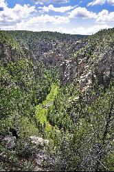
8.5 miles E of Camp Verde, ArizonaBullpen Day Use Area — better known to locals as the Bull Pen swimming hole — is a shady, family-friendly stretch of West Clear Creek below the Mogollon Rim near Camp Verde, Arizona. It's one of the most beloved cool-off spots in the Verde Valley: clear creek water, red-rock canyon walls, cliffs for jumping, and (if you're lucky) a rope swing or two, all within an easy walk of the parking area.
A short hike of about three-quarters of a mile from the lot leads down to the water, where a popular spot with a big red rock draws jumpers of all nerve levels — there are ledges of a few different heights, and the creek reaches around 7 feet deep in the swimming hole. It's a great spot for kids and families, with plenty of shallow water to splash in too. Beyond the swimming hole, the West Clear Creek Trail continues up a gorgeous canyon, so you can turn a quick swim into a full day of exploring, wading, and rock-hopping deeper into the wilderness.
The setting is the payoff. West Clear Creek carves one of the longest and most rugged canyons below the Mogollon Rim, and the water here runs clear and cool even when the desert above is baking. Anglers fish the creek, hikers work their way up the canyon, and on a hot afternoon the shaded pools are pure relief.
A few practical notes. Getting there involves a drive on Forest Road 618 (off Highway 260 east of Camp Verde), including some dirt road, so allow time. There's a vault toilet and room to park and picnic, but no trash service, so pack out everything you bring. This is a day-use area only — no overnight camping is allowed at Bullpen or the trailhead, though backpackers can find dispersed camping farther down the creek in the West Clear Creek Wilderness.
West Clear Creek is also a gateway to real backcountry. Strong hikers and backpackers use the trailhead here to launch multi-day trips deep into the West Clear Creek Wilderness, following the canyon upstream through a maze of pools, boulder gardens, and sheer red-and-cream cliffs — some sections require swimming through deep, cold pools with your pack. Even if you never go that far, the wildlife-rich riparian corridor, alive with birds, dragonflies, and the odd deer coming down to drink, makes the shaded creekside a lovely place to linger.
Come prepared with water shoes for the rocky creek bed, sun protection, and plenty of drinking water, and always check the depth before you jump, since water levels change with the season and flash floods can roar through this canyon after summer storms. Late spring through early fall is prime swimming season. Whether you stay by the swimming hole or venture up the canyon, Bull Pen is a classic Arizona creek day.
The Crack at Wet Beaver Creek
Rimrock, Arizona
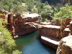
4.6 miles NE of Rimrock, ArizonaThe Crack is a popular swimming hole found by hiking the Bell Trail down to Wet Beaver Creek. After following the trail for about 3.5 miles away from the parking lot, take a detour to the left just before crossing the creek. From there, you will find the area known as The Crack, with water that is typically crystal clear, and rocks high enough to jump from. The Bell Trail winds along near the creek for most of the way, with side trails that will take you to the water periodically. The first time the trail crosses the river is just below The Crack, so if you're still looking for it, you've gone too far!
Most of the hike is through rocky red desert terrain, so be sure to bring plenty of water, extra sunscreen, and maybe a hat to protect from the hot sun. Never jump into water if you're not sure how deep it is.
Horses and their riders can access this trail by taking the Bruce Brockett Trail; there is trailer parking at the trailhead for the Bruce Brockett Trail.
Clear Creek Campground
Camp Verde, Arizona
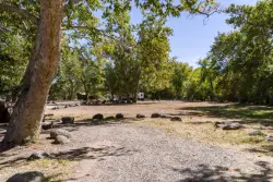
6.0 miles SE of Camp Verde, ArizonaWest Clear Creek flows along the boundary of this desert canyon country camp and is a popular place for hiking, swimming, wading and fishing. Cool water species such as smallmouth bass and green sunfish populate the stream near the campground. The oasis bordering the creek and extending into the campground is an excellent place for wildlife watching. It provides a productive home to a number of species of colorful songbirds and raptors. Beyond those lush environs, the Sonoran desert bristles with cactus and adds variety to any hike. Clear Creek Campground is grassy and flat with shade provided by tall cottonwoods. It has a relaxed and open atmosphere that keeps people coming back year after year. Just a short gravel road separates the campground from nearby paved SR 260.Courtesy of fs.usda.gov
Devil's Bridge
Sedona, Arizona
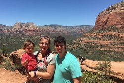
3.6 miles NW of Sedona, ArizonaWe loved the red rock views on this hike! It's a 3.6 mile round-trip trail, on rocky/sandy ground, and is fairly easy, until the last mile, which is steep. Dozens of jeeps and ATVs passed us - there are plenty of local tourist companies that can take you up there if you don't want to hike the whole way. Lots of dogs on the trail (use a leash). At the end, Devil's Bridge was AMAZING and beautiful! We hiked on Memorial Day weekend, and it was suuuper busy, so people were waiting in line to go out onto the rock bridge and take a selfie. We didn't want to wait forever so we just took a picture from the mountain. :) The weather at the end of May was lovely - not a cloud in the sky, but breezy enough that we didn't get too hot (probably 80 degrees F while we were hiking at 1:00 pm). There were soooo many cars that we had to park on the main road, and that added about a mile to our hike each way. We hiked with our 1 year old toddler, and just ended up taking turns carrying him the whole way since we didn't have a baby backpack. It took us about 2 hours to get up and about 90 minutes to get down.
Recommendations:
Take plenty of water. Go early so you can park in the parking lot or at least close to the trailhead. The trail is not good for a stroller; use a backpack for your baby. You'll want a camera - the views are breathtaking!


