


9 locations
Add Location
 Full Listing
Backpack, Camp, Hike, Horseback, Mountain Bike
Added on 7 Sep 2018
Full Listing
Backpack, Camp, Hike, Horseback, Mountain Bike
Added on 7 Sep 2018
 Full Listing
Swim
Added on 15 Jun 2018
Full Listing
Swim
Added on 15 Jun 2018
 Full Listing
Backpack, Hike
Added on 30 May 2018
Full Listing
Backpack, Hike
Added on 30 May 2018
 Full Listing
Cave
Added on 9 May 2018
Full Listing
Cave
Added on 9 May 2018
 Full Listing
Cave
Added on 9 May 2018
Full Listing
Cave
Added on 9 May 2018
 Full Listing
Sled
Added on 9 May 2018
Full Listing
Sled
Added on 9 May 2018
 Full Listing
Cross-country Ski, Hike, Mountain Bike
Added on 1 May 2018
Full Listing
Cross-country Ski, Hike, Mountain Bike
Added on 1 May 2018
Antelope Island State Park
Syracuse, Utah
10.0 miles SW of Syracuse, UtahLocated just 41 miles north of Salt Lake City, Antelope Island State Park encompasses a vast selection of outdoor activities and spectacular scenery providing a peaceful nature experience. Experience stunning 360-degree views as you drive around the State Park or try other activities such as exploring the roughly 20 miles of trails open for hiking, biking, and running or horseback riding. Picnic tables and designated campsites are available though RV hookups are not provided.
Enjoy the water as you kayak, fish, sail, or swim off of the Great Salt Lake’s largest island. Wild animals such as antelope, birds, bison, bobcats, coyotes, deer, and horned sheep roam freely and claim Antelope Island home. Watching the wildlife is a must. Be sure to take caution around wildlife and keep your distance. Do not touch or feed wildlife.
Absorb the beauty of nature through spectacular sunrises, sunsets, and the spectacular night sky. The Visitor Center includes publications, restrooms, and exhibits for all to enjoy. The best times of year for exploring Antelope Island are early spring an late fall. Beware of the bug situation in late spring and early summer. Bug spray is mandatory. Don't forget to bring drinking water as well to stay hydrated during your adventures.
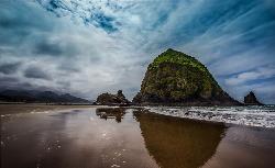
Haystack Rock
Cannon Beach, Oregon
0.6 miles SW of Cannon Beach, OregonHaystack Rock is a 235-foot (72-meter) sea stack in Cannon Beach, Oregon. It is sometimes claimed locally to be the third-tallest such "intertidal" structure in the world, but there are no official references to support this. A popular tourist destination, the monolithic rock is adjacent to the beach and accessible by foot at low tide. The Haystack Rock tide pools are home to many intertidal animals, including starfish, sea anemone, crabs, chitons, limpets, and sea slugs. The rock is also a nesting site for many sea birds, including terns and puffins.
Visitors to Haystack Rock can view many species of marine wildlife in their natural habitat during low tide. The thin strip of rock and sand that connects it to the beach at these times features many tide pools. The area surrounding the rock is popular for picnicking, kite-flying, and bird-watching. Artists and photographers can be found capturing the beauty of Haystack Rock on canvas or on film.
Courtesy of Wikipedia.com
0.7 mi
 Full Listing
Hike
Added on 30 May 2018
Full Listing
Hike
Added on 30 May 2018
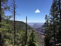
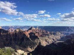
Bright Angel Point Trail
North Rim, Arizona
1.2 miles S of North Rim, ArizonaLocated at the North Rim of the Grand Canyon, the Bright Angel Point Trail is a steep, narrow, fully paved path leading to an incredible scenic viewpoint. The trail is conveniently located right next to the Grand Canyon Lodge and is only a short hike from the North Rim Visitor’s Center.
This trail encompasses stunning views from all angles and features numerous large rocks. These rocks are perfect for sitting on to relax and observe the beauty of the Canyon while also can be climbed for even more gorgeous views. The scenery constantly changes as you walk down the path and are stunning to look out upon as you return.
Keep the kiddos close as the adventure begins downhill with steep drop-offs on both sides. The steepness on the way out makes returning a bit more strenuous but is still very doable for all hiking levels. Large rocks and trees line both sides of the path for a good portion of the trail which is much less crowded than the South Rim.
Toward the end of the trail, you cross a small bridge which may seem scary, yet has guardrails conveniently placed both on the bridge as well as near the point in order to provide safety.
While the light reflecting off the Canyon appears to be flat around mid-day, Bright Angel Point is a marvelous place to watch the sunrise or sunset and experience dynamic reflections of incredible colors. The remarkable views make Bright Angel Point the most popular destination for photography at the North Rim.
Widforss Trail
North Rim, Arizona
0.8 miles NW of North Rim, ArizonaWidforss Trail overlooks the Grand Canyon as it leads along the beautiful North Rim. The peaceful forested trail features numerous picture perfect locations from the beginning of the trail on over to Widforss Point. You will find incredible Canyon views, lovely rocks, and fantastic forest trees.
The trail is well maintained, easy to follow, and typically not crowded. The trail is shaded for a large portion of the hike but still can be very hot. It has uphill inclines as well as dips and weaves in and out of the woods but does not require any climbing in order to accomplish. The trail provides several opportunities for hikers to sit on rock ledges to absorb the remarkable views. Great for hiking, trail running and backpacking. On average the 10-mile trek takes roughly 4 to 5 hours.
There is a pit toilet at the trailhead parking lot but no water sources along the way so be sure to pack water. There is an informational paper provided at the North Rim Visitors Center which corresponds with the trail. This paper points out specific areas to take note of and educate you about the area’s ecology and geology as you adventure along the trail.
1.8 mi
 Full Listing
Hike, Mountain Bike
Added on 16 May 2018
Full Listing
Hike, Mountain Bike
Added on 16 May 2018
Gailey Trail At Nicholls Park (Nicholls Hollow)
Kaysville, Utah
1.1 miles SE of Kaysville, UtahThe shady Gailey Trail at Nicholls Park (also known as Bair Creek or Nicholls Hollow) is perfect for walking, running, and enjoying the fresh air of nature all four seasons of the year. The nature trail has a nice tree cover overhead to keep you cool in the summer and is mostly dirt and bark. The trails trees leaves are incredible to admire in the autumn and transform into a magnificently snowy wonderland in the winter months as the white treetops are covered. While dogs are allowed along the trail, they must be on a leash. Trail map boards and benches are located along the way. There are small bridges to walk over streams throughout the trail. The trail is not difficult but there are multiple entrances to the Gailey trail and some are easier access than others. The parking lot closest to Main Street in Kaysville provides the least steep hill to access the trail whereas the entrance near the Nicholls playground and pavilions is quite steep. The trail is located below Castle Park of Fruit Heights City, known for its bright red castle tops, bark, swings and large grassy areas with a spectacular view of the mountains.
Minnetonka Cave
Saint Charles, Idaho
6.9 miles W of Saint Charles, IdahoMinnetonka Cave is the largest commercially developed limestone rock cave in the state of Idaho, and one of the highest, with an entrance elevation of 7,700 feet. The developed part of the cave contains nine separate "rooms" or chambers. The largest of these chambers is called the Ballroom, measuring more than 300 feet across and 90 feet high.
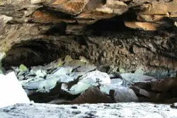
Civil Defense Caves
Rexburg, Idaho
23.0 miles N of Rexburg, IdahoThe caves are large lava tubes. The name comes from the cold war era when they were anticipated as a safe area in the case of an attack. The entrance is pretty bouldery and does require a small amount of agility. Once in, it's easy enough for even little kids. Off the entrance, there are two main tubes. The right is pretty easy, the left is a little more difficult but does have bats. The right tube is mostly a flat gravely floor with a very large arched ceiling with rocks and boulders here and there. There's plenty of room to run around. College kids often play glow in the dark tag and other similar night games out here. It's pretty well patroled due to the high interest. At the end is a little more like caverns that you can crawl around through.
The caves are pretty cold year round. You're even likely to find some ice near the entrance. You'll want to bring jackets, lights, and good footwear. Sadly there is quite a bit of broken glass throughout the caves.
The dirt road up to the caves is very rocky and often washed out. You probably want to drive something with pretty good clearance.
The caves are closed October through April to protect the bat habitat.
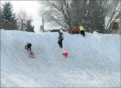
Smith Park
Rexburg, Idaho
1.0 miles E of Rexburg, IdahoWhen the snow piles up in the streets, the wonderful city of Rexburg moves the snow to the park. It gets piled on the side of the road on top of what is a small sledding hill to start with. The hill is probably about a 30-40 foot drop. It's great for kids and there's a utility box often used to build a jump. Because it's such a great hill with such a convenient location, it can get a bit crowded at peak sledding times.
I don't believe the added height from the city snow removal doesn't usually occur until the winter celebration in January. There's still a smaller hill there before that though.
Mueller Park Trail
Bountiful, Utah
2.9 miles SE of Bountiful, UtahThe Mueller Park Trail is a great year-round trail that's almost right off the road. It's considered moderate difficulty. It's a gradual grade with beautiful views. It's a popular trail in the summer so be prepared to move over for other bikers and hikers. The trail is generally wide enough for both.
Length:
- 13 mile round trip
- 3.6 mile to Elephant Rock
This is a very popular out-and-back ride, for good reason. It's full of smooth buff singletrack out of the city, with fast, flowy turns coming back down. It's steady, light-to-moderate climbing the whole way up to Rudy's Flat, with some minor technical sections in the upper half. Courtesy of MTBProject.com
This is a great little up and back route. You'll climb just shy of 2,000 feet over 6.5 miles, but it seems like less. You'll know you've reached the top when the trail levels out in a clearing. If you want to do a loop, you can continue on. The trail will drop more steeply than going back the way you came. However, there will be a few miles of road back to where you started. If you turn around, you reap the reward of the fast, flowy downhill back to your car. It's best to do this at an off-peak time as this is a popular trail and you may not want to interrupt that very fun downhill by all the necessary yelds to uphill riders. If you want to get most There is lots of vegetation along the way and the trees throw lots of color in the fall. Courtesy of Singletracks.com
×


