


5 Summer by whitekaylee1
first prev 1 next last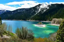
Palisades Creek Trail / Lakes and Waterfall Canyon
Irwin, Idaho
4.4 miles E of Irwin, IdahoThe Palisades Creek Trail is one of the classic hikes and backpacking trips of the Swan Valley region, climbing a gorgeous glacier-carved canyon to a pair of mountain lakes on the edge of the Palisades Wilderness Study Area, about 50 miles southeast of Idaho Falls (and an hour west of Jackson, Wyoming). Following clear, tumbling Palisades Creek nearly the whole way, it's a well-maintained, moderately graded trail that rewards hikers with waterfalls, wildflowers, and some of the finest mountain scenery in eastern Idaho.
The trail begins at the well-signed Palisades Creek trailhead at the end of the county road above the little community of Irwin, where there's a parking area and a Forest Service trailhead. From there the path threads a dramatic canyon of towering rock walls, crossing the creek on sturdy bridges and passing several waterfalls that spill from the heights — scenery that makes even the day hike to the lower lake feel like a true mountain adventure. Because it's so scenic and so accessible, it's deservedly popular; there's no permit or fee to hike, but weekends draw a crowd, and backpackers should plan for company at the more sought-after campsites.
It's about 4.3 miles to Lower Palisades Lake, gaining a gentle thousand feet or so — an ideal day hike or first-time backpacking trip. Strong hikers and overnighters can push on another 2.5 miles to Upper Palisades Lake (around 14 miles round trip), leaving the main trail to turn up Waterfall Canyon, where the namesake cascades tumble down the walls. Both lakes were formed ages ago when massive landslides came down the canyon and dammed the creek. The upper lake generally offers better backcountry camping, since the closer sites at the lower lake fill up first.
The fishing is superb. Palisades Creek is a major spawning tributary for the famous South Fork of the Snake, and it and the lakes teem with native Yellowstone cutthroat trout — a wonderful place to cast a line or simply relax by the water. Wildlife is everywhere: hikers regularly see moose (often standing belly-deep in the lakes), along with elk, deer, waterfowl, and mountain goats on the high walls.
This is genuine bear country — both black bears and grizzlies range here — so carry bear spray, know how to use it, make noise on blind corners, and store all food properly, especially if you camp. Because the trail lies within a Wilderness Study Area, it's open to foot and horse travel only (no bikes or motors), which helps keep it wild and quiet.
Timing matters: early in the season the trail can run with snowmelt and the lakes can be muddy and high, so late summer into fall is often the sweetest window — drier trail, settled lakes, and golden hillsides. Bring bug protection for early summer, plenty of water, sturdy footwear for the creek crossings, and layers for fast-changing mountain weather, and you'll quickly understand why Palisades Creek is such a regional favorite.
Mesa Falls
Ashton, Idaho
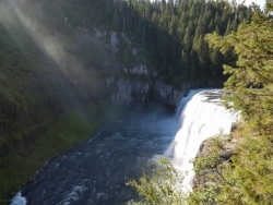
10.0 miles NE of Ashton, IdahoUpper Mesa Falls, aka Big Falls, is an absolutely awesome waterfall on the Henrys Fork of the Snake River. The falls drop 114 ft. and measure 300 ft. across. To get to the falls from the parking lot is 0.2 miles of paved walkway and several sturdy stairs with plenty of gaurdrails and handrails. There are several platforms along the route for viewing and taking photos. Catch it in the morning to see the rainbows in the lingering mist that often rises well above the platforms. There's a wheelchair accessible path that can get a pretty good view of the falls but does not go right down to it.
Lower Mesa Falls is about a mile down river from the Upper Falls. There's two great viewing options. One is from a cliff hovering 200 feet above the falls and the other is from the the Observation Site sitting 0.25 miles away and almost 500 feet above the falls. To get to the cliff above the falls, there's a trailhead on the South East end of the main parking lot. The trail is 1 mile each way (2 mile out and back) with about a 100 ft. difference in elevation (about the same as the stairs the the Upper Falls platforms). The trail goes through the woods well away from the river itself but there are no guardrails at the end when you're peering over the edge of the cliffs to see the waterfall. To see the falls from the observation site is free and the walk from your car to the lookout is only about 500 ft.
This is an Idaho State Park and there are day use fees. Passes have reciprocity with Harriman State Park which is only about 20 minutes away. Get there before 5pm to check out the old inn which has been transformed into a fun and informative visitor's center.
Fall River Bridge
Ashton, Idaho
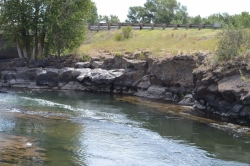
6.6 miles SW of Ashton, IdahoRight off Highway 20, there's a great spot to swim, swing, and dive. There's pullouts for parking right next to the bridge. There's a rope swing under the railroad bridge and a little swimming hole to the North. As always be careful of water levels. There are rocks down the middle of the river on the North side. If they're covered, the water is high.
Fun Farm Bridge
Saint Anthony, Idaho
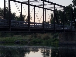
3.1 miles E of Saint Anthony, IdahoThe Fun Farm Bridge is a well-known bridge-jumping spot on the Henry's Fork of the Snake River just outside St. Anthony, in eastern Idaho, long popular with local teens and college students looking for a summer adrenaline rush. Also called the Funny Farm Bridge, it sits on the river northeast of town, where jumpers leap from the roadway or climb higher on the structure, and an old abandoned bridge next to the one in use offers deeper water and two distinct levels to jump from. It is genuinely popular, and it is also genuinely dangerous, which is the most important thing to understand before going anywhere near it.
Authorities warn strongly against swimming or jumping here. A diversion dam near the bridge creates powerful undercurrents in the river, and it is easy for swimmers to get caught in them; the water is considered especially dangerous before June, when spring runoff runs high, cold and fast. In 2019, a 23-year-old man drowned near the Fun Farm Bridge after jumping from it, and the Henry's Fork has claimed other lives in this area. This is not a gentle swimming hole; it is fast, cold, powerful water with a man-made hazard beneath the surface, and local officials discourage people from entering the water here at all.
We list the spot honestly rather than pretending it isn't used: people do jump here every summer. But anyone considering it should weigh the plain facts above first, understand that undercurrents from the diversion dam are invisible from the surface, never jump into water whose depth and hazards they haven't verified, and recognize that early-season conditions are the most lethal. Alcohol, cold shock and moving water are a deadly combination that has repeatedly turned tragic here.
For families and visitors simply wanting to cool off in the St. Anthony area, there are far safer options nearby, including the popular St. Anthony Sandbar in town, a mellow river swimming spot with amenities for a family picnic, and the swim beach at Egin Lakes out by the Sand Dunes. Choosing one of those over the Fun Farm Bridge is, bluntly, the difference that matters.
The setting itself is pretty, farm country along a classic Henry's Fork stretch of the Snake River Plain, and late summer brings the warmest, lowest water. But the honest bottom line is the one the authorities keep repeating: the diversion dam and its undercurrents make this a place to be extremely cautious about, and the safest way to enjoy the Henry's Fork here is from the bank.
St. Anthony Sandbar
Saint Anthony, Idaho
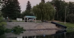
0.2 miles SE of Saint Anthony, IdahoThe Sand Bar is located on the Henry's Fork of the Snake River.. It has been the local swimming hole for more than 60 years and features a shelter, picnic tables, a water slide, a playground, sand boxes, a roped area for swimming and a diving board. A popular place for families, and visitors to cool off in the heat of the summer. There is no charge to use the Sand Bar, but the park cannot be reserved. It has a shallow, bordered swimming area for novice or non-swimmers, and a diving board and floating platform area for better swimmers.
The park has sandboxes on the sides of the steps down to the water and a small water slide which ends in the novice swimming area.
Swim at your own risk. The Sandbar is a popular place. No dogs are allowed in the park.
Take precautions when swimming in rivers with fast currents like this one.
The diving board is safe as long as you:
1. Don't use it when the river is running high, fast and cold.
2. Jump or dive off the front, not to the sides. There are huge rocks to the sides. Stick to the front to avoid getting hurt.
Don't swim in the "safe area" if the buoys aren't up. It is not safe until the City of St. Anthony puts them up.
Twin Bridges
St. Anthony, Idaho
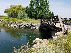
6.6 miles NE of St. Anthony, IdahoTwin Bridges is a beloved bridge-jumping and swimming spot on the river near St. Anthony, Idaho — a summer institution for families, teens, and college students across the upper Snake River Valley. The name comes from the setup: an old abandoned bridge stands right beside the one still in use, and the deep, slow water beneath the old span makes for about the best bridge jumping around, with no traffic to dodge and easy parking nearby.
The jumping is the main event, and it's well suited to a range of nerve. There are two distinct levels to leap from — a lower point around 11 feet and a higher one around 17 feet — so you can start small and work your way up, and the water below is plenty deep for cannonballs, flips, and gainers. Locals consider it about as good and as “reasonably safe” as bridge jumping gets, with one firm caveat: keep clear of the rocks along the sides, which can be exposed depending on the water level.
There's more to it than jumping. A little rope swing often hangs under the bridge — a favorite of the little kids — and a path up the river makes a good put-in for a short, mellow float back down. For families with young children, there's a sandbar on the north side just upstream of the action, perfect for wading and splashing away from the jumpers. The slow current is ideal for simply hanging out in the water while you watch your friends show off.
A fun local curiosity: downstream of the little rock dam on the north side lie the sunken remains of an old car, washed here after an accident years ago. When the water is low and clear you can spot its chrome bumper from the rocks and swim down for a look — a quirky bit of underwater sightseeing that regulars love.
Part of the appeal is how welcoming and community-minded the spot is. Generations of upper-valley families and Rexburg-area college students have made Twin Bridges their go-to summer swimming hole, and there's a friendly, everybody-shares-the-water vibe on a busy afternoon. It's the kind of simple, free, small-town summer pleasure that keeps people coming back week after week.
A few practical notes: it's a popular place, so expect a crowd on hot, sunny days and holidays — though it handles a lot of people well, and you rarely wait long to jump. Bring water shoes for the rocky spots, sun protection, and drinking water, always check the water depth and clear your landing before jumping (levels change through the season), keep an eye on kids near the current, and pack out all your trash. For a classic, easygoing eastern-Idaho swimming hole, Twin Bridges is hard to beat.
Monkey Rock
Saint Anthony, Idaho
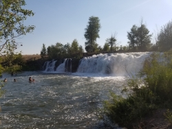
4.1 miles SE of Saint Anthony, IdahoMonkey Rock features a beautiful waterfall you can wade right up to during the summer. Just under the waterfall is a great spot to wade around in or even some shallow swimming pretty good for small children. Maybe you just want to take advantage of the great bank to bask in the summer sun. The water temperature is fairly cool, which by no means is unwelcomed during the hot summer months. You'll get used to the water fairly quickly once you're in. The waterfall is a fun feature at Monkey Rock, not to mention a popular engagement photo backdrop. The name "Monkey Rock" is derived from the "monkeys" who jump off the rocks at the top of the falls to the pool below. Though not a great height, it's important to be careful and only jump into areas clear of rocks and other hazards and where the water is deep enough that you won't hit bottom when you jump. There really isn't a safe spot to jump from the falls as it doesn't usually get more than 5 feet deep.
The real jumping location is off the Hog Hollow Bridge up the road from the waterfall.
PLEASE NOTE: On the roads leading to Monkey Rock, the speed limit is 35 mph for the last mile. There are kids, cows, horses, and dogs along that road and many people tend to speed going to and from Monkey Rock. Please slow down and stay safe.
Jumping Rock at Phelp's Lake
Jackson, Wyoming
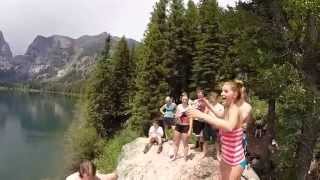
10.1 miles N of Jackson, WyomingTucked beneath the towering walls of Death Canyon in Grand Teton National Park, the Jumping Rock at Phelps Lake is one of the most spectacular places to take a leap in all of Wyoming. A lone granite boulder rises from the lake's eastern shore above clear, deep, glacier-fed water — a natural diving platform with a backdrop of soaring Teton peaks that few swimming holes on earth can match.
Reaching it is a rewarding hike through classic Teton scenery. From either the Death Canyon Trailhead or the Laurance S. Rockefeller Preserve, the trail winds through sagebrush flats and forests of aspen and lodgepole pine to the shore of Phelps Lake — figure roughly 5 to 6 miles round trip depending on your route. Follow the shoreline around to the east side and you'll find the famous rock, where a steady parade of hikers works up the nerve to jump.
The leap is a Teton rite of passage. The boulder offers ledges at a range of heights — lower spots for a quick splash and a higher perch (commonly cited around 20 feet up) for the bold. A few words of caution: always check the water and your entry before you jump, go feet-first, and be ready for a serious cold shock — this is glacial meltwater and it's frigid even in midsummer, so know your limits and get out before you're chilled. There are no lifeguards out here.
Timing matters. The Moose-Wilson Road that accesses these trailheads is typically closed from November into May, so the season runs roughly late spring through September, with mid-to-late summer offering the warmest (relatively speaking) water. This is also bear country — both black and grizzly bears frequent the Phelps Lake area — so carry bear spray, make noise, and store food properly. Parking, especially at the small Rockefeller Preserve lot, fills early, so start at first light.
Whether you make the jump or simply swim and soak in the view, the Jumping Rock at Phelps Lake delivers one of the Tetons' great summer experiences — a cold, clear mountain lake, a perfect natural diving board, and scenery that will stop you in your tracks.


