Walnut River Beach
El Dorado

Camp, Hike, and Swim
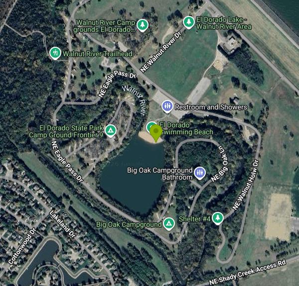
Walnut River Beach is the sand swim beach in the Walnut River Area of El Dorado State Park, the largest state park in Kansas, run by the Kansas Department of Wildlife and Parks (KDWP). It does not sit on El Dorado Lake itself. The beach lines the north shore of a small pond, roughly 14 acres by map measurement, just below the El Dorado Lake dam and next to the Walnut River as it leaves the reservoir. The park's other designated beach is at Bluestem Point, on the main reservoir several miles to the northeast, so check which one you are headed to before you leave town.
The Walnut River Area is about 3.5 km (2 miles) northeast of downtown El Dorado in Butler County, about 30 miles northeast of Wichita. From town, head east on East 12th Avenue toward the dam and turn into the state park's Walnut River Area, which spreads out under tall trees along the river. Parking lots and campground loops (Big Oak, Frontier Refinery and Eagle Pass) wrap around the pond, and the beach is a short walk from several of them. The park office, which sells daily permits, is at 618 NE Bluestem Road, El Dorado, phone (316) 321-7180.
The swim area is a modest strip of sand sloping into calm, still water. Because it is a pond and not the open reservoir, there is no boat traffic, no wind-driven chop and no river current at the beach, which makes it the gentler of the park's two beaches for young kids. Shallow Kansas ponds warm quickly in summer, so expect bathtub-warm water by July and murky water rather than clear. A shower house and picnic sites are close by. Lifeguard staffing could not be confirmed, so treat it as unguarded and keep children within reach. Kansas's water recreation season runs April 1 through October 31.
There is no separate beach fee, but every vehicle entering a Kansas state park needs a KDWP vehicle permit. Daily and annual permits are sold at the park office and online. The daily permit was $5 and the annual $25 until a commission-approved increase took effect November 1, 2026, so confirm the current rate with the park office before you go. Campers pay camping fees on top of the vehicle permit, and the beach itself is open to anyone with a permit, not just campground guests.
KDHE posts weekly blue-green algae advisories for Kansas lakes during the season. Check the current list before a trip. Small, warm, shallow ponds are the kind of water where blooms show up, so look for posted signs at the beach and skip swimming if the water looks like green paint or smells sour. Pets are not allowed on Kansas state park swim beaches. Keep swimming to the beach and stay out of the river channel below the dam, where releases from the reservoir can raise the flow quickly.
The Walnut River Area is mostly campground, with shaded sites along the river, a playground and the park's large amphitheater, which hosts concerts and festivals. Trails leave from the area, including the singletrack South Trail and the long Boulder Bluff horse and hiking trail. The Walnut River below the dam is a popular fishing spot, and part of the area is stocked with rainbow trout from November through March.
More Information
El Dorado Lake - Wikipedia
Aerial photo of El Dorado Lake and vicinity, facing northwest (2011)
https://en.wikipedia.org/wiki/El_Dorado_LakeEl Dorado State Park - Wikipedia
From Wikipedia, the free encyclopedia
https://en.wikipedia.org/wiki/El_Dorado_State_ParkKansas Is Changing Its State Park Fees November 1 — And Campers Are Losing A Popular Permit
The state recently approved park fee increases across the board, some going up over 40%, while the annual camping permit will be eliminated.
https://www.islands.com/2258774/kansas-state-park-vehicle-camping-utility-fee-increases-november-1-2026-campers-losing-popular-anual-permit/Kansas Wildlife and Parks approves park fee increases, new hunting regulations
The Kansas Wildlife and Parks Commission has approved several changes to state park fees and hunting regulations.
https://www.wibw.com/2026/08/28/kansas-wildlife-parks-approves-park-fee-increases-new-hunting-regulations/Walnut River Campground - El Dorado KS, 67042
Aptly named along the Walnut River at the state park’s southwestern corner, this campground seems like a world of its own. Tall trees form an umbrella over much of the road system and camping spots. Cabins are available in Walnut River Campground, but reservations are highly recommended. The campground has access to a variety of hiking trails, from short and ADA accessible to the 22-mile Boulder Bluff Trail. The area has a nice swimming beach, and a secluded area that’s stocked with rainbow trout November-March.
https://www.travelks.com/listing/walnut-river-campground/27284/Where to hit the beach in Kansas!
Check out these local beaches for a little summer sun, swimming, and family fun!
https://www.travelks.com/blog/stories/post/where-to-hit-the-beach-in-kansas/Be courteous, informed, and prepared. Read trailhead guidelines, stay on the trail, and don't feed the wildlife.
Read More
- Plan Ahead and Prepare
- Travel & camp on durable surfaces
- Dispose of waste properly
- Leave what you find
- Minimize campfire impacts
- Respect wildlife
- Be considerate of other visitors
Directions
From El Dorado
- Head north on S West Ave toward W Wesson StPass by AutoZone Auto Parts (on the left in 1.4 mi)(3.1 mi)
- Turn right onto N Calion Rd (10.9 mi)
- Continue onto US-167 N (35.9 mi)
- Turn left to stay on US-167 N (55.6 mi)
- Merge onto I-530 N/
US-167 N/ US-65 N via the ramp to Little Rock (10.1 mi) - Take the exit onto I-30 E/
US-167 N/ US-65 N toward Downtown/ Little Rock (4.7 mi) - Take exit 143A to merge onto I-40 W/
US-65 N toward Fort Smith Continue to follow I-40 W(141 mi) - Take exit 12 for I-49 N toward Fayetteville (0.4 mi)
- Continue onto I-49 NEntering Missouri(125 mi)
- Keep left to continue on MO-249 N (5.6 mi)
- Take the I-49BL/
MO-171 N exit on the left toward Webb City (0.6 mi) - Continue onto I-49BL/
MO-171 N/ E MacArthur Dr/ State Hwy 171 N (0.6 mi) - At the traffic circle, take the 2nd exit onto I-49BL/
E MacArthur Dr (1.0 mi) - Continue straight onto MO-171 N (2.0 mi)
- At the traffic circle, take the 2nd exit onto MO-171 N/
Demott Dr Continue to follow MO-171 N(5.2 mi) - At the traffic circle, take the 2nd exit onto MO-171Entering Kansas(10.0 mi)
- Continue onto KS-171 W (4.9 mi)
- Continue onto US-400 W (70.4 mi)
- At the traffic circle, take the 2nd exit and stay on US-400 W (47.7 mi)
- Turn right onto SE Gray Rd (2.8 mi)
- Continue onto SE 82nd Ter/
Flinthills Rd/ Rosalia-Keighley Rd Continue to follow Flinthills Rd(8.2 mi) - Turn left onto US-54 W (9.0 mi)
- Turn right onto SE Bluestem Rd (0.9 mi)
- Turn right onto SE Parallel St (0.1 mi)
- Slight left onto NE Bluestem Rd (0.6 mi)
- Turn left onto NE Shady Creek Access Rd (1.5 mi)
- Turn right onto Boulder Bluff Rd (0.7 mi)
- Turn left onto NE Walnut River Dr (0.2 mi)
- Continue onto NE Eagle Pass Dr (0.2 mi)
- Turn left to stay on NE Eagle Pass Dr (0.4 mi)
- Continue onto NE Big Oak LnDestination will be on the right(0.4 mi)