White Lake Park
White Lake
Canoe, Kayak, and Swim
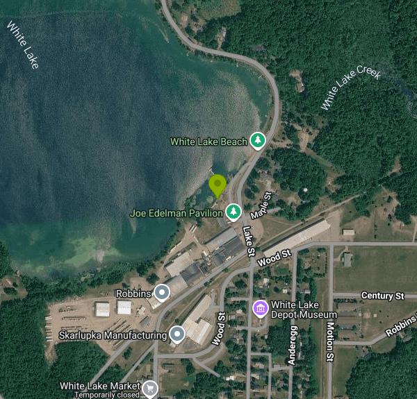
White Lake Park is the village beach of White Lake, a small community of about 260 people in eastern Langlade County, Wisconsin. The park sits on the east shore of White Lake, a spring-fed lake of roughly 153 acres, and is run by the Village of White Lake, which also manages the public boat landing in the same park. The lake takes its name from the white sand and marl on its bottom, and it was once used as a mill pond for the Yawkey-Bissell Lumber Company. Its waters are unusually clear, which is why scuba divers come here to look for logging and railroad relics.
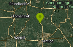
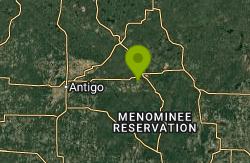
The park is on Lake Street (County Highway M) at the north edge of the village, a few minutes' walk from the small downtown. Travel Wisconsin lists the address as 1190 Lake St, White Lake, WI 54491. A paved parking area runs along the shore beside the boat ramp, with stalls for cars and for vehicles with trailers. The village lies roughly 20 miles east of Antigo as the crow flies, and about 4 miles west of Highway 55 and the Wolf River.
The swim area is a sand beach with a marked swimming zone and a swim raft anchored offshore. The bottom near shore is sand and marl, and the lake drops off to a maximum depth of 42 feet, so the water gets deep well beyond the raft. Because the lake is fed by springs, expect it to feel cooler than shallow lakes in the region, especially early in summer. The DNR rates the lake's general condition as excellent, and older state surveys recorded water clarity of more than 20 feet. No lifeguards are mentioned in any official listing, so plan on swimming at your own risk and watching children closely.
Admission to the park is free; Travel Wisconsin lists it as free admission, and the Wisconsin DNR records the landing as a village-managed public access with no fee noted. The village does not publish posted hours or a set swim season online. Pets are not allowed in White Lake Park or on the beach. For questions, the Village of White Lake office is at 715-882-8501.
The main hazard here is boat traffic. The public ramp and an accessible fishing pier sit right next to the beach, and motorboats launch and land within sight of swimmers. A no-wake rule applies on the lake from 6 pm to 10 am, which makes evenings and early mornings calmer for swimming. Stay inside the marked area and away from the ramp. The deep, clear water also means depth can be hard to judge from above, so check before jumping off the raft.
Other facilities include picnic tables, restrooms, the Joe Edelman Pavilion with covered seating, a newer playground and a short walking path. Anglers of any ability can fish from the pier, and paddlers can put in at the kayak launch. The village holds a Fourth of July celebration with fireworks each year, and summer Music in the Park evenings take place at the White Lake Pavilion on Lake Street. The Wolf River, known for its rapids and rafting, is a short drive east if you want a second stop.
More Information
Beat the heat with a visit to Langlade County beach
Langlade County may be known as the County of Trails, but for folks looking to beat the summer season, we may be the County of Beaches. Five of the best are located at Jack Lake, Summit Lake, Mueller’s Lake, White Lake, and, Phlox Pond.
https://www.langladecounty.org/media-center/langlade-county-news/beat-the-heat-with-a-visit-to-langlade-county-beach-2022-07-06/Home | Village of White Lake
Welcome to the Official Website of Village of White Lake in White Lake, WI!
https://villageofwhitelake.com/Swimming and Beaches | Antigo/Langlade County Chamber of Commerce
Antigo/Langland County Chamber of Commerce where Water, Woods and Wildlife come together. Visit us for a Membership Directory, Calendar of Events, Outdoor Activities, Lodging, Dining, Shopping & more.
https://www.antigochamber.com/recreation-trails/swimming-and-beaches/Water Detail - White Lake, Wolf River - Langlade and Evergreen Rive Watershed (WR18)
White Lake, Wolf River - Langlade and Evergreen Rive Watershed (WR18)
https://apps.dnr.wi.gov/water/waterDetail.aspx?key=11254White Lake Access, Wisconsin boat ramp and access | How's Your River
Public boat ramp and water access at White Lake Access on White Lake in Wisconsin. Map, directions, nearby USGS conditions, and amenities.
https://www.howsyourriver.com/access_sites/white-lake-3White Lake Park | Travel Wisconsin
White Lake Park is a charming destination nestled along the scenic shores of White Lake. The park offers a relaxing sand beach with a designated swimming area and a swim raft—perfect for summer fun. Anglers of all ages and abilities can enjoy fishin
https://www.travelwisconsin.com/outdoors/on-the-water/white-lake-park
- Plan Ahead and Prepare
- Travel & camp on durable surfaces
- Dispose of waste properly
- Leave what you find
- Minimize campfire impacts
- Respect wildlife
- Be considerate of other visitors
Directions
From White Lake
- Head north on White Lake Dr toward Tarheel Cir (1.2 mi)
- Turn left onto US-701 Hwy S (5.8 mi)
- Turn right onto NC-242 N/
NC-53 W Continue to follow NC-53 W(23.7 mi) - Slight left toward NC-53 W/
Cedar Creek Rd (0.1 mi) - Continue onto NC-53 W/
Cedar Creek Rd Pass by Subway (on the left in 7.5 mi)(10.8 mi) - Slight left onto NC-210 N/
NC-24 W (2.1 mi) - Turn right onto NC-210 NPass by Ruby Tuesday (on the right in 8.9 mi)(9.1 mi)
- Continue onto NC-87 N/
N Bragg Blvd Continue to follow NC-87 NPass by Bank of America (with Drive-thru ATM) (on the left in 1.2 mi)(20.9 mi) - Keep left to continue on NC-87 BYP (1.6 mi)
- Continue onto US-421 N (37.1 mi)
- Take exit 180 toward Liberty (0.3 mi)
- Slight right onto Old 421 Rd (2.5 mi)
- Continue onto S Greensboro St (1.4 mi)
- Continue onto Old 421 Rd (4.2 mi)
- Continue onto Greensboro St (0.3 mi)
- Continue onto Old 421 Rd (1.3 mi)
- Continue onto Liberty Rd (0.8 mi)
- Turn left onto NC-62 (0.6 mi)
- Turn right onto the ramp to Greensboro (0.4 mi)
- Merge onto US-421 N (6.8 mi)
- Take exit 197 to merge onto I-85 S toward Winston - Salem/
Charlotte (5.8 mi) - Slight right onto US-421 N (signs for I-73 N/
Winston-Salem/ Martinsville) (0.6 mi) - Merge onto I-73 N/
US-421 N (6.1 mi) - Slight left onto US-421 N (signs for I-40 W/
Winston-Salem) (0.6 mi) - Merge onto I-40/
US-421 N (5.2 mi) - Take exit 206 for US-421 N toward Salem Pkwy Kernersville/
Winston-Salem/ Downtown (0.3 mi) - Continue onto US-421 N (6.2 mi)
- Take exit 227 for NC-74 W toward US-311 (0.8 mi)
- Merge onto I-74 W/
NC-74 (12.9 mi) - Continue onto US-52 N (20.9 mi)
- Take exit 18 for I-74 W toward I-77/
Wytheville (0.5 mi) - Continue onto I-74 W (11.2 mi)
- Keep right to stay on I-74 W, follow signs for I-77 N/
Wytheville Entering Virginia(5.0 mi) - Continue onto I-77 N (31.9 mi)
- Take the exit onto I-77 N/
I-81 S toward Bluefield/ Wytheville (9.1 mi) - Take exit 72 for I-77 N toward Bluefield/
Charleston W.VA (0.4 mi) - Continue onto I-77 NToll roadEntering West Virginia(127 mi)
- Slight left onto I-64 W (17.9 mi)
- Take exit 40 toward Winfield/
Pt. Pleasant (0.6 mi) - Merge onto US-35 NEntering Ohio(96.2 mi)
- Slight left onto US-35 W (signs for Dayton) (63.8 mi)
- Take the US-35 W exit toward Dayton (1.1 mi)
- Continue onto US-35 W (12.6 mi)
- Take the exit onto I-75 N toward Toledo (8.3 mi)
- Take exit 61 to merge onto I-70 W toward Airport/
Indianapolis Entering Indiana(104 mi) - Keep left to stay on I-70 W (3.4 mi)
- Take exit 83B to merge onto I-65 N toward Chicago (147 mi)
- Take exit 259A to merge onto I-80 W/
I-94 W/ US-6 W toward Chicago Continue to follow I-80 WToll roadEntering Illinois(19.5 mi) - Continue straight onto I-294 NToll road(26.3 mi)
- Keep left, follow signs for I-294 N/
Milwaukee (453 ft) - Continue onto I-294 NToll road(22.7 mi)
- Continue onto I-94 WToll road(19.4 mi)
- Keep left to stay on I-94 WToll roadEntering Wisconsin(36.6 mi)
- Keep left to stay on I-94 W (2.6 mi)
- Continue onto I-43 N (123 mi)
- Take exit 192A to merge onto US-141 N/
US-41 N toward Marinette/ Iron Mountain (16.3 mi) - Take exit 187 on the left for US-141 toward Crivitz/
Iron Mt (0.5 mi) - Continue onto US-141 N (15.4 mi)
- Turn left onto Co Hwy M/
Co Rd M (5.8 mi) - Turn right onto Co Hwy B/
Co Rd B (4.0 mi) - Continue onto County Hwy ZZ (3.0 mi)
- Turn left onto WI-64 W (13.2 mi)
- Turn right onto WI-32 N/
WI-64 W (7.1 mi) - Turn left onto WI-64 W (13.2 mi)
- Turn left onto N White Lake Dr (0.6 mi)
- Turn left onto Lake St (1.0 mi)
- Turn rightDestination will be on the right(374 ft)