Whitebreast Beach
Knoxville

Camp, Canoe, Hike, Kayak, and Swim
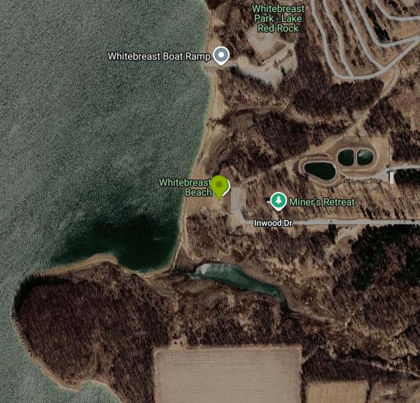
Whitebreast Beach is a designated swimming beach on the south shore of Lake Red Rock, run by the U.S. Army Corps of Engineers, Rock Island District, as part of its Whitebreast Recreation Area. Lake Red Rock formed behind Red Rock Dam on the Des Moines River after the dam was finished in 1969, and at normal pool it covers about 15,500 acres, which makes it the largest lake in Iowa. The beach sits in a wooded cove on the west side of the Whitebreast peninsula, near where White Breast Creek enters the lake, about 6 miles northeast of downtown Knoxville and roughly the same distance southwest of Pella.
From Knoxville, take County Highway T-15 northeast for about 8 miles, turn north on County Highway S-71 and follow it about 2 miles toward the Whitebreast campground. On the Corps campground map, the beach road is signed separately from the camping loops, shared with the Miner's Retreat shelter. It ends at a small parking area by the water. The campground's mailing address, 971 Highway S71, Knoxville, works for navigation apps.
The swim area is a stretch of shoreline marked off with buoyed swim lines. There are no lifeguards, so children need an adult watching them. Lake Red Rock is a working flood-control reservoir fed by the Des Moines River, so the water is usually murky, the depth at the swim line depends on the pool level that week, and the width of the sand can look very different from one summer to the next. The Corps lists the beach as its own recreation site, separate from the campground, with a picnic area, a group shelter and a hiking trail.
The Corps collects a day-use fee at its Lake Red Rock beaches from Memorial Day weekend through Labor Day weekend. The Corps sets a national minimum of $5 per private vehicle, $2 per adult arriving on foot or by bike, with children under 16 free, and the Lake Red Rock beaches have been listed at $5 per vehicle. Payment is by debit or credit card at an automated fee machine (no cash or checks), and you display the receipt on your dashboard. A USACE annual day-use pass, or an America the Beautiful Senior, Access or Military pass, covers the fee. Fees and beach dates can change, so check the signs at the lot or call the Lake Red Rock office at 641-828-7522.
Two problems close this beach in a typical summer. High water is the first. When heavy rain upstream raises the lake, the Corps pulls the swim lines and closes Whitebreast and North Overlook beaches until it can mark a safe swim area again, as happened in July 2024. Bacteria is the second. The Corps tests both beaches weekly through a contract with Iowa State University and posts Swimming Not Recommended signs when bacteria counts run high. Read the posted signs before you go in.
The rest of the Whitebreast area includes a 132-site Corps campground with showers, playgrounds and a boat ramp, the Whitebreast Point picnic shelter (free on a first-come basis when it is not reserved) and the enclosed Miner's Retreat shelter. Paddlers can use the designated water trails along the lake's shoreline, and hiking and biking trails run through the hardwood forest around the lake. Bald eagles winter on Lake Red Rock from November through March.
More Information
Automated Fee Machines Installed at Lake Red Rock | Ventek International
Posted By: Andrew Schneider April 14, 2022 @ 4:47 am New this year, Lake Red Rock has installed automated fee machines at all US Army Corps of Engineers (USACE)-managed boat launches and beaches. Those using the services can follow any onscreen instructions, insert a debit or credit card, and display a ticket/receipt on the dashboardread more
https://ventek-intl.com/automated-fee-machines-installed-at-lake-red-rock/Corps Lakes Gateway: Iowa - Lake Red Rock
An official website of the United States government Here's how you know
https://corpslakes.erdc.dren.mil/visitors/projects.cfm?Id=B515070Lake Red Rock - Camping | Iowa | Recreation.gov
Reserve camping, permits & activities at Lake Red Rock, Iowa. 12 campgrounds. Book official reservations on Recreation.gov.
https://www.recreation.gov/gateways/160NEWS RELEASE
The U.S. Army Corps of Engineers (USACE) announced today that beginning Jan. 1, 2016, the recreation day use fees charged for boat launches and swimming beaches managed by USACE will change to a simpler fee structure. The fee for a USACE annual pass to these facilities will also change.
https://corpslakes.erdc.dren.mil/employees/cecwon/pdfs/15dec23-UseFeeNews.pdfSwimming not advised at Lake Red Rock beaches, several other Iowa beaches
IOWA — On Friday, the Iowa Department of Natural Resources (DNR) said that swimming is not advised at 12 state beaches this week. According to the DNR’s website, all 12 of the beaches were found to ha...
https://www.yahoo.com/news/iowa-dnr-says-swimming-not-191952423.htmlSwimming Not Recommended At Two Lake Red Rock Beaches
Ottumwa News, Ottumwa Iowa, Area Obituaries, Education Briefs, Local Columns
https://ottumwapost.com/swimming-not-recommended-at-two-lake-red-rock-beaches-p15867-236.htmWhitebreast Camp, Lake Red Rock - Recreation.gov
Explore Whitebreast Camp in Lake Red Rock, Iowa with Recreation.gov. Whitebreast Camp is located on Lake Red Rock, Iowa's largest lake. It is just 10 minutes from Pella, known for its Dutch heritage, and 15 minutes from Knoxville
https://www.recreation.gov/camping/campgrounds/233413Whitebreast Point Shelter (IA), Lake Red Rock - Recreation.gov
Explore Whitebreast Point Shelter (IA) in Lake Red Rock, Iowa with Recreation.gov. Whitebreast Point Shelter is a day use facility located within Whitebreast Campground. The shelter is located on Lake Red Rock, Iowa's largest lake. It is just
https://www.recreation.gov/camping/campgrounds/251539Be courteous, informed, and prepared. Read trailhead guidelines, stay on the trail, and don't feed the wildlife.
Read More
- Plan Ahead and Prepare
- Travel & camp on durable surfaces
- Dispose of waste properly
- Leave what you find
- Minimize campfire impacts
- Respect wildlife
- Be considerate of other visitors
Directions
From Knoxville
- Head west toward Broadway SW (72 ft)
- Turn left toward Broadway SW (194 ft)
- Turn right onto Broadway SW (0.1 mi)
- Slight left onto Oak Ave (0.2 mi)
- Turn right onto Blackstock Ave (0.3 mi)
- Continue onto Marion St (0.5 mi)
- Turn left onto W Baxter Ave (184 ft)
- Turn right to merge onto I-275 N (2.7 mi)
- Continue onto I-75 NEntering Kentucky(171 mi)
- Keep left to continue on I-64 W, follow signs for Frankfort/
Louisville (55.5 mi) - Take exit 19B for I-265 N/
KY-841 N/ Gene Snyder Fwy toward 19B (0.3 mi) - Merge onto I-265/
KY-841 E/ Gene Snyder Fwy Continue to follow I-265Toll roadEntering Indiana(19.1 mi) - Take exit 34A to merge onto I-65 N toward Indianapolis (100 mi)
- Take exit 106 for I-465 W/
I-74 W (0.4 mi) - Merge onto I-465 W/
I-74 (15.4 mi) - Keep right to continue on I-74, follow signs for PeoriaEntering Illinois(166 mi)
- Take exit 163 for I-74 W toward Peoria (0.9 mi)
- Continue onto I-74 (27.4 mi)
- Keep right to stay on I-74 (7.7 mi)
- Keep left to stay on I-74 (46.2 mi)
- Take exit 46A to merge onto US-34 W toward Monmouth (11.9 mi)
- Take the exit toward Cameron Rd (0.3 mi)
- Turn left onto 140th Ave (2.1 mi)
- Continue onto Coldbrook St (0.1 mi)
- Turn right onto 180th Ave (7.6 mi)
- Continue onto US-34 W (13.4 mi)
- Continue onto US Rte 34 (7.2 mi)
- Continue onto US-34 WEntering Iowa(32.3 mi)
- Slight right to merge onto IA-27 N/
US-218 N/ US-34 W toward IA-163 W/ Iowa City/ Ottumwa (2.5 mi) - Slight right onto the US-34 W ramp to Mt Pleasant/
Ottumwa (0.9 mi) - Continue onto US-34 W (46.7 mi)
- Keep left to continue on US-63 N (27.0 mi)
- Continue onto IA-163 W (3.1 mi)
- Take exit 57 for IA-92 toward Oskaloosa/
Knoxville (0.4 mi) - Turn left onto IA-92 W (17.7 mi)
- Turn right toward Old Hwy 92 (417 ft)
- Turn left onto Old Hwy 92 (1.6 mi)
- Turn right onto Hwy T15 (1.6 mi)
- Turn left onto Co Hwy S71 (2.5 mi)
- Turn left onto Inwood Dr (0.4 mi)
- Turn leftDestination will be on the left(138 ft)