


Dexter Beach
Crescent City
Canoe, Kayak, and Swim
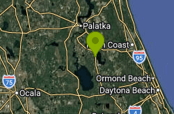
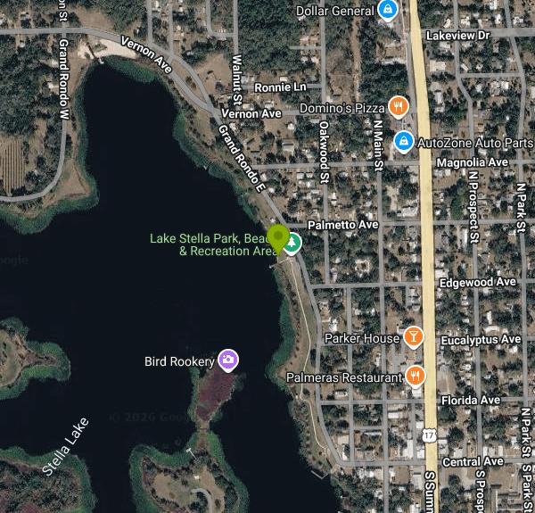
Dexter Beach is the City of Crescent City's swimming area on Lake Stella, the smaller of the two lakes that frame this Putnam County town. The beach sits inside Thomas A. Dexter Bicentennial Park, a narrow strip of city parkland along Grand Rondo East on the lake's eastern shore that also goes by the name Lake Stella Park. A 1973 marker at the site records its dedication as Florida's first bicentennial park, named for Thomas A. Dexter. The city's Parks and Recreation page lists Dexter Beach at 325 E. Grand Rondo with picnic tables and a Lake Stella swimming area.
Crescent City lies on US 17 roughly 20 miles south of Palatka. From US 17 (Summit Street) downtown, head west a few blocks on Central Avenue to Grand Rondo East, which runs right along the lakeshore. The beach and playground are at the north end of the park strip, roughly a tenth of a mile south of Palmetto Avenue. Parking is along the roadside pull-offs and the small lot by the park. The public boat ramp, gazebo and dock are at the south end of the same strip where Central Avenue meets the water.
The swim area is a small sand beach with a short floating pier next to a playground. Lake Stella is a small, sheltered lake with marshy edges, so the water is usually calm, with no current to speak of, and it warms into the 80s F through a Florida summer. The city posts no depth or bottom information, so wade in and check before swimming, and watch for vegetation beyond the sand. The city does not list lifeguards for the beach; the one time a guarded swim area was advertised here was during a one-day Putnam County Sheriff's Office paddling event in June 2023. Swim at your own risk and keep children within reach.
There is no entry fee. The city's park rules set the same hours for all city parks: 6:00 a.m. to 9:00 p.m. from April through September, and 6:00 a.m. to 7:00 p.m. from October through March, unless a special events permit says otherwise. The city code allows use of boat ramps, docks and shorelines outside those hours only for boating and fishing.
Lake Stella is a Florida freshwater lake, and alligators can turn up anywhere in it. Do not swim at dusk or after dark, keep pets out of the water, and leave the area if you see a large gator nearby. The Florida Department of Health in Putnam County has issued blue-green algae alerts for nearby Crescent Lake, including the Sunrise boat ramp a few blocks east of this beach. Stay out of water that looks green, scummy or smells off, and check the county health alert page before a summer visit.
The rest of the park strip has a gazebo, picnic spots and the public boat ramp, and the city has used the gazebo for sunset concerts. Kayaks and canoes can launch from the ramp to explore the lake's coves and marsh edges, where wading birds, wood ducks and the occasional bald eagle turn up. The Crescent City Historic District, with more than 200 late 19th and early 20th century buildings, starts just east of the lake, and Crescent Lake's waterfront parks are a short drive across town.
More Information
Crescent City Venture Corps presents – Crescent City, Florida
Saturday Sunset at Stella, join us at the Gazebo near the Boat Dock on Lake Stella in Crescent City, Florida, Live Music by: Salt & Pine, Bring your blanket
https://crescentcity-fl.com/2021/12/23/crescent-city-venture-corps-presents/Crescent Lake Paddling Trail - Putnam County, FL
Description Crescent Lake is approximately 30 square miles of clean, sparkling water, lush shoreline vegetation, and excellent scenery. It is over 11 miles long from North to south and from …Read More »
https://www.putnam-fl.gov/departments/general-services/parks-recreation/trails/crescent-lake-paddling-trail/Health Alert - Florida Department of Health in Putnam County
Advisories, Alerts, Notices, Cautions, etc.
https://putnam.floridahealth.gov/category/health-alert/Lake Stella Public Boat Ramp, Florida boat ramp and access | How's Your River
Public boat ramp and water access at Lake Stella Public Boat Ramp on Lake Stella in Florida. Map, directions, nearby USGS conditions, and amenities.
https://howsyourriver.com/access_sites/lake-stella-public-boat-rampParks & Recreation – Crescent City, Florida
All Parks Hours of operation: open from 6:00 a.m. to 9:00 p.m. April through September, 6:00 a.m. to 7:00 p.m. October through March except as permitted by Spec
https://crescentcity-fl.com/parks-recreation/Putnam County Sheriff’s Office Presents: – Crescent City, Florida
Cops, Kids & Kayaks June 3, 2023, 10:00 am - 4:00 pm Paddle on Lake Stella with Putnam Blueways and Trails Limited AVailabilty- last launch 2
https://crescentcity-fl.com/2023/05/01/putnam-county-sheriffs-office-presents-2/
- Plan Ahead and Prepare
- Travel & camp on durable surfaces
- Dispose of waste properly
- Leave what you find
- Minimize campfire impacts
- Respect wildlife
- Be considerate of other visitors
Directions
From Crescent City
- Head northeast on 9th St toward H St (0.3 mi)
- Turn left onto US-101 N (3.9 mi)
- Take exit 794 for US-199 toward I-5/
Grants Pass (0.5 mi) - Continue onto US-199 NPass by NAPA Auto Parts - Cave Junction Auto Parts (on the right in 48.3 mi)Entering Oregon(78.9 mi)
- Merge onto I-5 S via the ramp to Medford (20.4 mi)
- Take exit 35 for OR-99 S/
Blackwell Rd toward Central Pt (0.3 mi) - Turn right onto OR-140/
OR-99 N/ Blackwell Rd (1.5 mi) - Continue straight onto OR-140 (3.2 mi)
- Turn right onto W Antelope Rd (2.7 mi)
- Turn right onto OR-140 E (0.3 mi)
- Turn left to stay on OR-140 E (1.9 mi)
- At the traffic circle, take the 2nd exit onto OR-140 W (66.9 mi)
- Turn left onto OR-140/
OR-66 E Continue to follow OR-140(4.8 mi) - At the traffic circle, take the 2nd exit onto OR-140 E/
Southside Expy Continue to follow OR-140 E(1.4 mi) - Turn left onto OR-140 E/
OR-39 N (1.7 mi) - Turn right onto OR-140 E (90.4 mi)
- Turn left onto OR-140 E/
US-395 N/ N G St (signs for Burns) Continue to follow OR-140 E/(4.7 mi)US-395 N - Turn right onto OR-140 EEntering Nevada(64.8 mi)
- Continue onto NV-140 (44.4 mi)
- Turn right to stay on NV-140 (65.5 mi)
- Turn right onto US-95 S (29.0 mi)
- Turn left onto NV-795 E (1.2 mi)
- Turn right onto E 2nd St (1.0 mi)
- Turn left to merge onto I-80 EEntering Utah(350 mi)
- Take the exit onto I-15 S/
I-80 E toward Cheyenne/ Las Vegas (3.2 mi) - Take exit 304 for I-80 E toward Cheyenne (0.6 mi)
- Continue onto I-80 EPassing through WyomingEntering Nebraska(872 mi)
- Take exit 397 to merge onto US-77 S/
Homestead Expy toward NE-2/ Beatrice/ Nebraska City (9.3 mi) - Slight left onto NE-2Entering Iowa(48.9 mi)
- Continue onto IA-2 E (2.9 mi)
- Turn right to merge onto I-29 S toward Kansas CityEntering Missouri(88.3 mi)
- Keep left to stay on I-29 S (46.1 mi)
- Merge onto I-29 S/
I-35 S (4.4 mi) - Continue onto US-71 (0.2 mi)
- Merge onto I-70 E/
US-71 S (0.3 mi) - Slight left onto I-70 E/
US-24 E/ US-40 E (signs for St Louis) Continue to follow I-70 E(127 mi) - Slight right toward Interstate 70 Dr SE (0.1 mi)
- Merge onto Interstate 70 Dr SE (0.1 mi)
- Keep left (0.1 mi)
- Merge onto I-70 E (119 mi)
- Take the exit toward I-55 N/
I-64 E/ Illinois (0.2 mi) - Continue onto I-70 EEntering Illinois(2.6 mi)
- Take exit 3 for I-64 E toward Louisville (0.1 mi)
- Take the ramp onto I-64 E (71.1 mi)
- Merge onto I-57 S/
I-64 E (3.9 mi) - Slight right onto I-57 S (signs for Memphis) (47.3 mi)
- Take exit 44 for I-24 E toward Nashville (1.3 mi)
- Continue onto I-24 E (37.4 mi)
- Keep right to stay on I-24 EPassing through KentuckyEntering Tennessee(138 mi)
- Take exit 44A to merge onto I-24 E/
I-65 S toward Nashville (2.3 mi) - Keep left to continue on I-24 E, follow signs for I-40 E/
Chattanooga/ Knoxville (2.8 mi) - Take exit 50A for I-24 E toward I-40 E/
Knoxville/ Chattanooga (0.3 mi) - Continue onto I-24 E/
I-40 E (1.7 mi) - Take exit 213A for I-24 E toward Chattanooga (0.4 mi)
- Continue onto Exit 53 (signs for I-440/
Memphis) (0.4 mi) - Keep left to continue on I-24 E, follow signs for ChattanoogaPassing through GeorgiaEntering Tennessee(133 mi)
- Take exit 185A to merge onto I-75 S toward AtlantaEntering Georgia(97.0 mi)
- Keep left to stay on I-75 S (8.6 mi)
- Keep right to stay on I-75 S, follow signs for I-85 S/
Atlanta (0.5 mi) - Continue onto Horace E. Tate Fwy (0.2 mi)
- Merge onto I-75 S/
I-85 S (7.4 mi) - Keep left to continue on I-75 S, follow signs for International Airport/
Macon (64.8 mi) - Keep right to continue on I-475 S, follow signs for Bypass to I-75 South Valdosta (16.1 mi)
- Merge onto I-75 SEntering Florida(192 mi)
- Take exit 435 to merge onto I-10 E toward Jacksonville (53.8 mi)
- Take exit 350A-B to merge onto FL-23 S/
Cecil Commerce Center Pkwy/ First Coast Expy Continue to follow FL-23 S/First Coast Expy Toll road(15.3 mi) - Continue onto First Coast ExpyToll road(17.3 mi)
- Take the exit toward US-17 S (0.3 mi)
- Turn right onto US-17 SPass by Subway (on the right in 23.3 mi)(46.9 mi)
- Turn right onto Vernon Ave (0.3 mi)
- Sharp left onto Grand Rondo EDestination will be on the right(0.2 mi)
Other Swimming Holes, Canoeing Areas, and Kayaking Areas Nearby

Salt Springs Recreation Area
Salt Springs, Florida
14.5 miles SWBig mineral spring in the Ocala National Forest with a walled swim area over the boils, a 160-site campground, marina and a run to Lake George.
Camp, Canoe, Hike, Kayak, Swim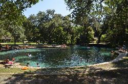
Juniper Springs Recreation Area
Astor
21.1 miles SWA Civilian Conservation Corps spring pool in the Ocala National Forest that holds 72 degrees year round over a sand and limestone bottom, with a historic millhouse waterwheel, a seven mile canoe run, and 79 campsites. Day use is $14.50 per person.
Camp, Canoe, Hike, Kayak, Swim
Ponce De Leon Springs State Park
De Leon Springs, Florida
22.6 miles SEA splendidly clear spring pool, aquarium-bright with guppies, with changing rooms and a famous on-site pancake house — a Florida gem with a $3.25 entry fee.
Swim
Ocala National Park
Chiefland, Florida
24.8 miles SClear springs in the Ocala National Forest maintain a constant 72°F year-round — a brisk and refreshing swim in any season, with fees at all locations.
Swim
Blue Spring State Park
DeBary, Florida
35.4 miles SA spring-fed run with a gentle current carrying swimmers under overhanging trees and Spanish moss to the St. Johns River — with possible winter manatee sightings and a raised boardwalk for non-swimmers.
Swim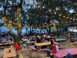
Keystone Beach
Keystone Heights
39.0 miles NWFree city-run beach and playground on the north shore of Lake Geneva in downtown Keystone Heights, open 7 a.m. to 10 p.m., with a marked swim area beside the 1924 Historic Pavilion.
Canoe, Kayak, Swim
Rock Spring
Apopka, Florida
46.8 miles SA spring-fed Florida tubing run past a barred cave and through clear cold water — sometimes closed due to bacterial counts from animals, so check ahead before visiting.
Swim
Wekiwa Springs
Apopka, Florida
48.4 miles SSwim near Apopka, Florida
SwimNearby Campsites
Salt Springs Recreation Area
Salt Springs, Florida
14.5 miles SWBig mineral spring in the Ocala National Forest with a walled swim area over the boils, a 160-site campground, marina and a run to Lake George.
Camp, Canoe, Hike, Kayak, Swim
Juniper Springs Recreation Area
Astor
21.1 miles SWA Civilian Conservation Corps spring pool in the Ocala National Forest that holds 72 degrees year round over a sand and limestone bottom, with a historic millhouse waterwheel, a seven mile canoe run, and 79 campsites. Day use is $14.50 per person.
Camp, Canoe, Hike, Kayak, Swim


