


Gorham Area
Lincoln, New Hampshire

| GPS: |
44°23'11.1"N 71°10'0.0"W Maps | Directions |
| State: | New Hampshire |
Swim

- Plan Ahead and Prepare
- Travel & camp on durable surfaces
- Dispose of waste properly
- Leave what you find
- Minimize campfire impacts
- Respect wildlife
- Be considerate of other visitors
Directions
From Lincoln, New Hampshire
- Head southwest (325 ft)
- Continue onto Recycle Rd (0.1 mi)
- Turn left onto NH-112 W (0.1 mi)
- Turn right to merge onto I-93 N (11.8 mi)
- Take exit 35 for US-3 N toward Lancaster/Twin Mountain (0.5 mi)
- Continue onto US-3 N (11.9 mi)
- Turn right onto NH-115 N (9.7 mi)
- Turn right onto US-2 E (12.5 mi)
- Turn right onto Main StDestination will be on the right(1.7 mi)

Other Swimming Holes Nearby

Cold River Area
Carrabassett Valley, Maine
13.1 miles SESpectacular swimming holes near the Cold River campground on the Maine-New Hampshire border — some clothing-optional spots tucked into a beautiful White Mountain setting.
Swim
North Conway Area
Concord, New Hampshire
21.7 miles SSwim near Concord, New Hampshire
Swim
Sawyer Area
Hinsdale, New Hampshire
23.0 miles SSwim near Hinsdale, New Hampshire
Swim
Kancamagus Area
Lincoln, New Hampshire
28.1 miles SWSwim near Lincoln, New Hampshire
Swim
Horseshoe Falls
Lincoln, New Hampshire
30.4 miles SWCLOSED. Private Property. Closed to the public due to vandalism. Please take better care of areas we're permitted to use.
Swim
Lincoln Area
Lincoln, New Hampshire
30.4 miles SWA cluster of swimming options near the busy tourist town of Lincoln, New Hampshire — some spots clothing-optional; see local listings for details.
Swim
Falling Waters
Lincoln, New Hampshire
30.4 miles SWSwim near Lincoln, New Hampshire
Swim
Rumford Area
Yarmouth, Maine
33.5 miles NEA variety of swimming holes in the vicinity of Rumford and Mexico, Maine — some spots clothing-optional; check local listings for specific access details.
Swim
Route 25 Area
Phillips, Maine
39.6 miles NESwim near Phillips, Maine
Swim
Roque Bluffs State Park
Phillips, Maine
39.6 miles NESwim near Phillips, Maine
Swim
Moxie Falls
Phillips, Maine
39.6 miles NESwim near Phillips, Maine
Swim
Swiftwater Bridge
Bath, New Hampshire
42.6 miles SWSwim near Bath, New Hampshire
Swim
Weare
Bath, New Hampshire
42.6 miles SWSwimmable river pools up to 4 feet deep along a Weare, New Hampshire roadside, including a 30-foot-wide section with a rope swing — rocky terrain means caution is advised, especially for small children.
Swim
Smalls Falls
Rangeley, Maine
45.6 miles NESwim near Rangeley, Maine
Swim
Weston's Beach
Rangeley, Maine
45.6 miles NESwim near Rangeley, Maine
Swim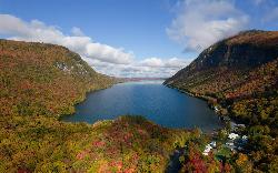
Lake Willoughby South Beach
Westmore
48.2 miles NWA free public beach at the south tip of Lake Willoughby in Westmore, Vermont, with the cliffs of Mount Pisgah and Mount Hor rising on either side of deep, clear, cold water.
Canoe, Hike, Kayak, Swim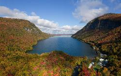
Southwest Cove
Westmore
48.3 miles NWA sand beach at the southwest corner of Lake Willoughby in Willoughby State Forest, reached by a short trail from the south end lots. Free, cold, clear water, no lifeguards, and long used as a clothing-optional beach.
Canoe, Hike, Kayak, SwimNearby Campsites

Maple Haven Campground
Woodstock, New Hampshire
39.1 miles SWA private 28-acre campground tucked in the heart of New Hampshire's White Mountains with breathtaking views, untouched nature, and both indoor and outdoor camping options.
Camp
Squam Lake Camping
Center Harbor, New Hampshire
49.5 miles SA conservation organization that maintains over 50 miles of hiking trails around the Squam Lakes in New Hampshire, with camping available on Moon and Bowman Islands.
Camp, Canoe, Kayak


