Hancock Beach
Hancock

Camp, Canoe, Kayak, and Swim
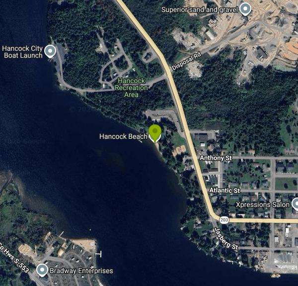
Hancock Beach is the city swimming beach inside the Hancock Recreation Area, a park of just over 28 acres run by the City of Hancock on the north shore of the Keweenaw Waterway. The city calls this water Portage Lake, while many maps label the reach west of the Portage Lake Lift Bridge as the Portage Canal. Either way it is Lake Superior water moving through the waterway, and the beach faces south across the channel toward the Houghton side. The street address is 1900 Jasberg Street (M-203), and the city campground next door is at 2000 Jasberg Street.
From downtown Hancock, follow M-203 west for about a mile and the beach is on the water side of the road. A parking lot sits right behind the sand, and footpaths link the beach to the campground. The city lists the facility as open to the public from May 15 to October 15 each year. It does not post separate daily beach hours, but a campground attendant is on duty from 8 a.m. to 8 p.m.
The beach is about 300 feet of sand. You can wade in from shore or use the recreation pier the city opened in 2019, which has a platform for jumping into the water, a separate floating launch for kayaks and canoes built to ADA standards, and space for larger boats to tie up. The city has not published depths for the swim area, so check the water under the platform before you jump. The city describes the water as fresh and cool, and since it is Lake Superior water it stays chilly well into summer. No lifeguard is on duty, and the city's own wording is that you swim at your own risk.
Using the beach is free. The city charges daily fees only for campsites (from $18 a night for tent sites up to $35 for 50-amp, water-service and waterfront sites, under rates dated March 2023) and a separate fee for non-campers who launch boats at the campground ramp. The amount of that launch fee is not listed on the city's page.
The Western Upper Peninsula Health Department samples the Hancock Recreation Area beach for E. coli weekly during the swim season and posts results on the state's BeachGuard site. Advisories are most likely after heavy rain, when runoff and waterfowl droppings wash into the lake, so give it a day or two after a storm. In 2020 the health department also issued a harmful algal bloom advisory for Portage Lake and the Portage Canal. Stay out of water that looks like pea soup, spilled paint or floating scum, and keep dogs from drinking it. Boats come and go from the pier and the nearby ramp, so swimmers around the dock should watch for traffic. As of early October 2026 the season is in its final week, with the facility closing October 15.
Away from the water, the park has a large picnic area with a pavilion that can be rented, restrooms and a changing house, a playground with ADA swings, three sand volleyball courts, horseshoe courts and a few public grills. A privately run concession stand sells snacks, ice cream and drinks and rents kayaks and paddleboards. The city campground has 72 sites, 58 with electric hookups for RVs and 14 for tents. A native-plant bioswale at the beach, kept up partly by volunteers from the Keweenaw Wild Ones, catches runoff before it reaches the lake.
More Information

- Plan Ahead and Prepare
- Travel & camp on durable surfaces
- Dispose of waste properly
- Leave what you find
- Minimize campfire impacts
- Respect wildlife
- Be considerate of other visitors
Directions
From Hancock
- Head south (0.2 mi)
- Take the Lima Ave exit toward Findlay (0.3 mi)
- At the traffic circle, take the 4th exit onto the I-75 N/
OH-15 W ramp (0.4 mi) - Merge onto I-75 N/
OH-15 W via the ramp to Toledo Continue to follow I-75 N(35.3 mi) - Take exit 192 on the left to merge onto I-475 N/
US-23 N toward Maumee/ Ann Arbor (13.6 mi) - Keep left to continue on US-23 N, follow signs for Sylvania/
Ann Arbor Entering Michigan(39.1 mi) - Continue onto I-94BL/
US-23 N (1.5 mi) - Continue onto US-23 N (4.8 mi)
- Take the exit onto M-14 W/
US-23 N toward Flint (2.6 mi) - Keep right to continue on US-23 N (14.7 mi)
- Keep right to stay on US-23 N (31.0 mi)
- Merge onto I-75 NToll road(229 mi)
- Take exit 344B to merge onto US-2 W/
U.S. Bicycle Rt 10 Continue to follow US-2 WPass by Subway (on the right in 0.6 mi)(65.5 mi) - Turn right onto M-77 N (17.3 mi)
- Turn left onto M-28 W (35.2 mi)
- At the traffic circle, take the 2nd exit onto M-28 W/
E Munising Ave Continue to follow M-28 WPass by Dairy Queen (Treat) (on the left in 0.5 mi)(37.9 mi) - Continue straight onto Cherry Creek RdPass by Flagstar Bank (on the left)(1.8 mi)
- Turn right onto Co Rd 480 (12.5 mi)
- Turn right onto S Healy Ave (0.1 mi)
- Turn left onto E Main St (0.3 mi)
- Turn right onto N Teal Lake Ave (0.5 mi)
- Turn left onto US-41 N (2.7 mi)
- At the traffic circle, take the 2nd exit and stay on US-41 N (0.9 mi)
- At the traffic circle, take the 2nd exit and stay on US-41 NPass by Anytime Fitness (on the left in 1.8 mi)(84.8 mi)
- Turn right to stay on US-41 N (0.5 mi)
- Turn right onto Reservation St (358 ft)
- Turn left onto Quincy St (0.6 mi)
- Continue straight to stay on Quincy St (1.1 mi)
- Slight right onto Jasberg St (0.2 mi)
- Turn leftDestination will be on the left(449 ft)