


Mounds SRA Beach
Brookville
Camp, Canoe, Hike, Kayak, and Swim
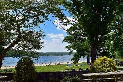
Mounds SRA Beach is the public swimming beach at Mounds State Recreation Area, on the east shore of Brookville Lake in Franklin County, Indiana. The lake is a 5,260-acre U.S. Army Corps of Engineers reservoir that backs up the East Fork of the Whitewater River behind a dam finished in 1974, and the Indiana Department of Natural Resources runs the recreation side as Mounds SRA and Quakertown SRA. Don't confuse it with Mounds State Park in Anderson. Since Quakertown's beach closed for good, the sand at Mounds is the only designated swim beach on the lake.
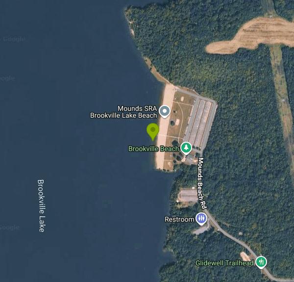
The property address is 14108 State Road 101, Brookville, IN 47012. From downtown Brookville, take SR 101 north about five miles to the Mounds SRA entrance, then follow the beach road west through the woods to the shoreline lots. Several paved and gravel parking areas sit just behind the beach, with restrooms, a sand volleyball court, picnic tables and shade trees on the grass above the sand. The DNR keeps mobility mats on the beach during the season so wheelchairs and strollers can reach the water. If you are driving in from the Liberty side, the Dunlapsville Road bridge over the lake is closed through the 2026 season, so plan on the SR 101 and SR 44 detour.
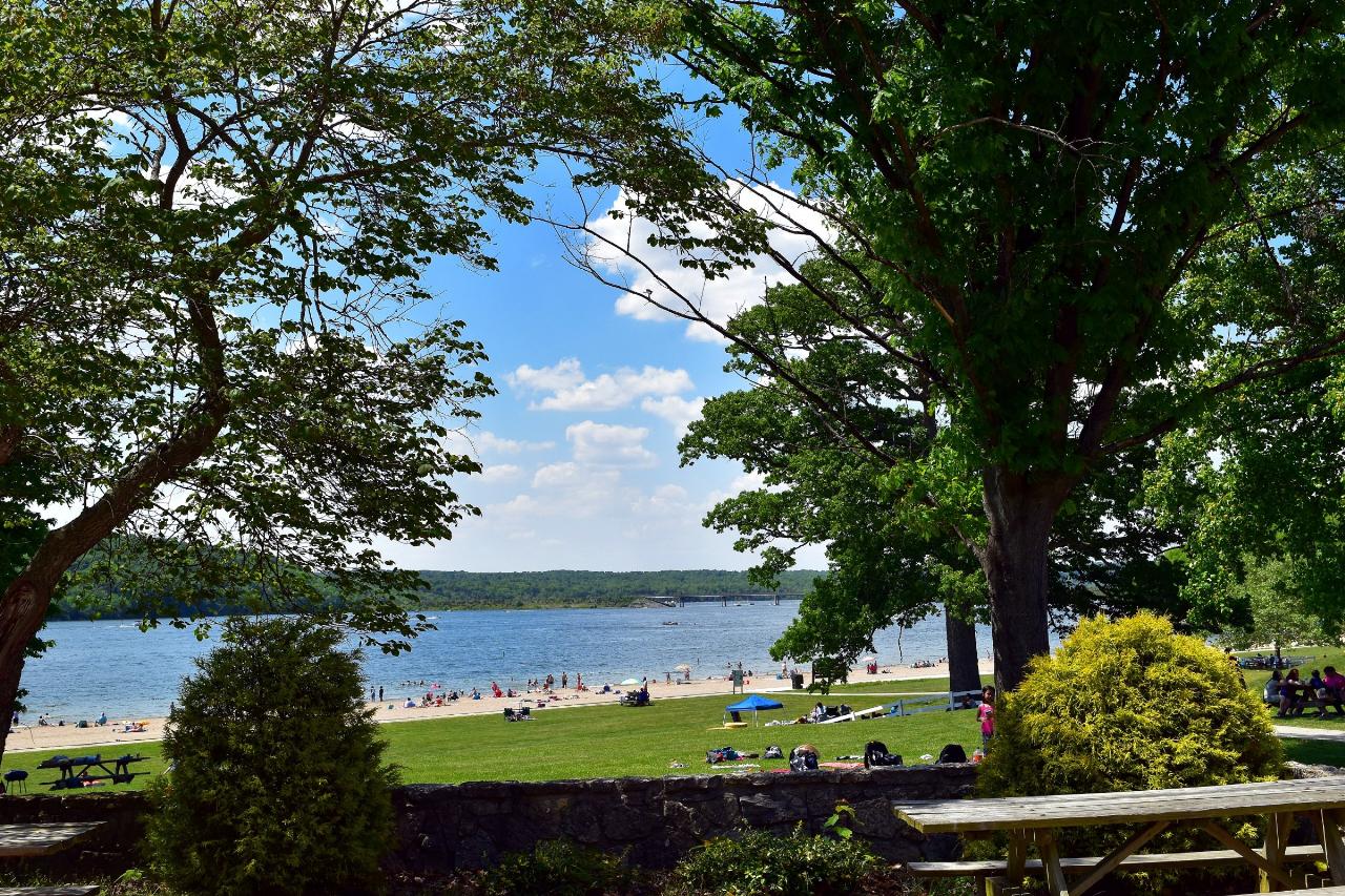
The beach is a long strip of sand facing west across a wide reach of the lake, with a gradual entry into open reservoir water. There is no current to speak of, but this is a big lake with powerboat and ski traffic beyond the swim area, and wind can push up a chop by afternoon. Water warms slowly in June and is at its warmest in July and August. Swimming is typically allowed from Memorial Day weekend through Labor Day. Indiana DNR runs a swim-at-your-own-risk policy at its beaches (Indiana Dunes is the only exception), so do not count on a lifeguard here. Children 12 and under must be with someone 16 or older, and pets are not allowed on the beach.
There is no separate charge for the beach. You pay the standard state gate fee for a state-managed lake: $7 per day for a vehicle with Indiana plates or $15 per day for a vehicle with out-of-state plates, covering the driver and all passengers. An Indiana annual entrance pass ($50, or $120 for nonresidents) also gets you in. The DNR does not post separate beach hours online, so call the property office at 765-647-2657 if you are planning an early or late swim.
Water quality is the main thing to check before you go. The DNR samples its beaches for E. coli and blue-green algae during the season, and the Mounds beach was closed briefly in July 2025 when an E. coli test came back high, reopening after a clean retest. A yellow algae advisory still allows swimming, but you should avoid visible scum, not swallow the water, keep dogs out of it and shower afterward. The current status is posted on the Brookville Lake page and the statewide state park alerts page.
Mounds SRA is also one of the largest campgrounds in the Indiana system, with 388 electric and 62 full-hookup sites, a camp store and shelters, and the Fairfield and Templeton Creek trails start near the beach road. The Glidewell Trail loops past a 2,000-year-old Native American mound, and the 16.5-mile Wolf Creek Trail runs the wild west shore. Nine boat ramps around the lake make it easy to bring a canoe or kayak, and the lake has a strong walleye fishery.
More Information
Brookville Lake (Indiana): Camping, Walleye Fishing & Beach Guide
5,260-acre Brookville Lake: 450 campsites, Mounds SRA beach, Indiana's premier walleye fishery and 25+ miles of trails in the Whitewater valley.
https://www.americasstateparks.org/state-park/brookville-lake/Indiana Department of Natural Resources: Accessible Beaches & Swimming Pools
Several Indiana state park properties offer mobility accommodations at beaches.
https://www.in.gov/dnr/places-to-go/accessibility/swimmingState Parks: Blue Green Algae Blooms
Blue-Green algae advisories at Indiana State Parks.
https://www.in.gov/dnr/state-parks/publications-and-brochures/blue-green-algae-bloomsState Parks: Entrance Fees
Entrance Fees for Indiana State Parks & Reservoirs
https://www.in.gov/dnr/state-parks/rates-and-fees/entrance-feesState Parks: Indiana State Park Alerts
Property advisories and closings for Indiana State Parks and Reservoirs
https://www.in.gov/dnr/state-parks/parks-lakes/advisories-and-closings/indexState Parks: Miscellaneous Fees
Swimming, toboggan and commercial photography fees at Indiana State Parks
https://www.in.gov/dnr/state-parks/rates-and-fees/miscellaneous-feesUPDATE: Beach at regional lake reopens after high levels of a dangerous bacteria – WHIO TV 7 and WH
A beach at a regional lake is temporarily closed after testing revealed high levels of E. coli in the water.
https://www.whio.com/news/local/beach-regional-lake-closed-swimming-due-high-levels-dangerous-bacteria/RKRWV5X3KVCA5AGYVTSHH5AZ6I/Be courteous, informed, and prepared. Read trailhead guidelines, stay on the trail, and don't feed the wildlife.
Read More
- Plan Ahead and Prepare
- Travel & camp on durable surfaces
- Dispose of waste properly
- Leave what you find
- Minimize campfire impacts
- Respect wildlife
- Be considerate of other visitors
Directions
From Brookville
- Head south on Dogwood Hill toward Cedar Swamp Rd (105 ft)
- Turn left onto NY-107 S/
Cedar Swamp Rd (2.0 mi) - Merge onto NY-25 W/
Jericho Tpke via the ramp to New York (1.1 mi) - Keep right to continue on Store Hill Rd (0.2 mi)
- Merge onto I-495 W via the ramp on the left to New York (10.4 mi)
- Take exit 31N-S for Cross Island Parkway toward Whitestone Brg/
Kennedy Arpt (0.2 mi) - Keep right to continue on Exit 31 North, follow signs for Cross Island Pkwy N/
Whitestone Br and merge onto Cross Island Pkwy (3.4 mi) - Take exit 33 for I-295/
Throgs Neck Br toward Bronx/ New England Toll road(0.5 mi) - Merge onto I-295 NToll road(2.6 mi)
- Keep left to stay on I-295 N, follow signs for I-95 S/
Cross Bronx ExpwyW/ Geo Washington Br (1.3 mi) - Continue onto Cross Bronx Expy (0.6 mi)
- Merge onto I-95 S (4.7 mi)
- Slight right onto Cross Bronx Expy/
Interstate 95 Lower Level S/ Trans-Manhattan Expy/ U.S. 1 Lower Level S (signs for I-95 S/ US-1 S/ George Washington Br Lower Level) (0.6 mi) - Keep left to continue on Interstate 95 Lower Level S/
U.S. 1 Lower Level S, follow signs for I-95 S/ New Jersey Entering New Jersey(1.8 mi) - Keep right to continue on I-95 (2.7 mi)
- Keep left to continue on I-95 S, follow signs for NJ Turnpike South/
US-46/ Newark Toll road(2.4 mi) - Keep left to continue on I-95 S/
NJ Turnpike S, follow signs for Trenton Toll road(2.6 mi) - Keep left to continue on I-95 S, follow signs for Express EZPassToll road(7.7 mi)
- Take exit 14-14 A-14 B-14 C for I-78 W toward US-1/
US-9/ Newark Airport Toll road(1.6 mi) - Continue onto I-78 WToll road(0.1 mi)
- Keep left to continue on I-78 Express W/
Phillipsburg–Newark Expy, follow signs for I-78 W/ Garden State Parkway/ Clinton Toll road(9.2 mi) - Continue onto I-78 W/
Phillipsburg–Newark Expy (16.9 mi) - Slight right to stay on I-78 WToll roadEntering Pennsylvania(109 mi)
- Take the exit onto I-81 S toward Harrisburg (18.8 mi)
- Keep right to stay on I-81 S (18.4 mi)
- Take exit 52 for US-11 toward I-76/
Penna Turn Pike/ New Kingstown/ Middlesex (0.3 mi) - Keep right, follow signs for Carlisle Barracks and merge onto US-11 SPass by McDonald's (on the right in 0.7 mi)(1.0 mi)
- Slight right to merge onto I-76 WToll road(152 mi)
- Take exit 75 to merge onto I-70 W toward New Stanton/
Wheeling WV Entering West Virginia(67.1 mi) - Keep left to continue on I-470 W, follow signs for ColumbusEntering Ohio(10.9 mi)
- Merge onto I-70 W (118 mi)
- Take exit 101A for I-71 N toward Cleveland (0.6 mi)
- Continue onto I-71 N (0.4 mi)
- Take exit 109 A for I-670 E toward Airport (1.4 mi)
- Merge onto I-670 W (3.1 mi)
- Take the I-670 W exit toward Dayton (1.0 mi)
- Merge onto I-70 WEntering Indiana(95.6 mi)
- Take exit 156A for US-40 W/
National Rd (0.3 mi) - Merge onto US-40 W/
National Rd E (427 ft) - At the traffic circle, take the 1st exit onto US-40 W (1.3 mi)
- Turn left onto Garwood Rd (1.2 mi)
- Turn right onto Hodgin Rd (1.0 mi)
- Continue onto S L St (1.6 mi)
- Turn left onto US-27 S/
S 8th St Continue to follow US-27 S(13.1 mi) - Continue straight onto IN-101 S/
N Main St/ S State Rd 101 Continue to follow IN-101 S(9.3 mi) - Turn right onto Mounds Beach Rd (2.6 mi)
- Turn left (246 ft)


Other Swimming Holes, Hiking Trails, Canoeing Areas, and Kayaking Areas Nearby

Whitewater Memorial State Park Beach
Liberty
8.2 miles NThe swim beach on 200-acre Whitewater Lake in Whitewater Memorial State Park near Liberty, Indiana. Open Memorial Day to Labor Day, no lifeguards, and free once you pay the $7 in-state or $15 out-of-state vehicle entrance fee.
Camp, Canoe, Hike, Swim
St Paul Area
Bloomington, Indiana
34.8 miles WSeveral privately developed quarry water parks near Bloomington offer swimming, diving platforms, zip lines, and more — check individual sites for fees and details.
Swim
Columbus Area
Bloomington, Indiana
42.2 miles SWSwim near Bloomington, Indiana
Swim
Little Miami River Area
Bellville, Ohio
47.3 miles ESwim near Bellville, Ohio
Swim
Caesar Creek State Park- Spillway Trail
Waynesville, Ohio
49.5 miles EForty-three miles of hiking trails ranging from gentle meadows to rugged ravines wind through this 7,900-acre Ohio park centered on a stunning blue lake.
Hike
Caesar Creek State Park Visitor Center Trail
Waynesville, Ohio
49.5 miles EA multi-use recreational area at Caesar Creek Lake offering camping, hiking, horseback riding, boating, fossil collecting, and more across 2,830 acres of water and 7,720 acres of land.
Hike


