


124 Mountain Bike Trails near Sport Loop
first prev 1 2 3 4 5 6 7 next lastShowing Mountain Bike Trails within 50 miles Distance miles of McDowell Mountain Rd, Fountain Hills, AZ 85268, USA City, Zip, or Address
Emery Henderson
Phoenix, Arizona
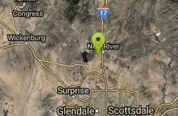
31.0 miles NWBct(Black Canyon Trail) trail head features paved parking and restrooms. From here you can head south on relatively flat ground, or North, working into the desert hills, on multiuse...
Mountain Bike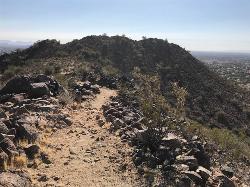
Sunrise Mountain Trail
Peoria, Arizona
31.3 miles WThe Sunrise Mountain Trail can be found within the suburban area of Peoria, Arizona; it is made of up 3 sequential loops; each loop harder than the last. The trail is easy to find, as...
Hike, Mountain Bike
San Tan
Queen Creek, Arizona
32.2 miles STke the Goldmine trail (approximately 1.1 miles uphill on wide trail) Take left onto SanTan for approximately 1.5 miles. At this point you will reach a T. Go to right for the San Tan...
Mountain Bike
South Mountain Park / National Trail
Phoenix, Arizona
33.2 miles SWNational trail can be acended or decended. Both require expert skills and fitness. You cannot and will not find a climb this technical, challenging and fun in AZ. It will kick your...
Mountain Bike 12.6 mi
National Trail
Phoenix, Arizona
33.7 miles SWNational Trail is the gem of South Mountain and home to the infamous Waterfall. It’s a local favorite as well as a destination trail for MTB snowbirds. Like most trails in the Sonoran...
Hike, Mountain Bike
Black Canyon Trail
Black Canyon City, Arizona
37.0 miles NWThis discription is for the Table Mesa trail head which has 1.5 miles (N) out on the Black Canyon Trail to the Little Pan Loop. The Little pan loop will take you down to the Agua Fria...
Mountain Bike
Black Canyon Trail - Little Pan Loop
Black Canyon City, Arizona
37.2 miles NWThe Black Canyon National Recreation Trail will be a 79-mile hiking, mountain biking and equestrian trail stretching from the Sonoran Desert lowlands in Phoenix to the high grasslands...
Mountain Bike 8.3 mi

Estrella Mountains Competitive Track
Tolleson, Arizona
40.2 miles SWThe third competitive track in the Maricopa County Regional Park system, located in Estrella Mountain Regional Park, was completed in February 2000. The track consists of two loops totaling 13 miles....
Hike, Horseback, Mountain Bike
Picket Post
Superior, Arizona
40.8 miles SEFrom the parking lot head south as this trail begins to climb, and climb very high into the hills. You don't climb Picket Post mountain but go around it's western side as you climb and...
Mountain Bike 13.8 mi
Butterfield to Gadsen Loop Trail
Goodyear, Arizona
42.8 miles SWAs with other trails in Estrella, the trail is wide and the surface tends to be rather benign, varying from mostly smooth, to occasionally strewn with small rocks, sandy in the washes. Butterfield...
Hike, Horseback, Mountain Bike 2.9 mi
Coldwater Trail
Goodyear, Arizona
42.8 miles SWThe Cold Water Trail #27 is a seldom visited, remote backcountry destination along the backdrop of the rugged Verde Rim with healthy mixed vegetation and unique geology. The trail was originally used...
Hike, Horseback, Mountain Bike
Estrella Mountain Park
Goodyear, Arizona
43.0 miles SWNice mix of singletrack and doubletrack. One way loops, long loop and tech loop. A few mild climbs and some mild rock gardens, just let it ride. There is a lot of loose rocks on the...
Mountain Bike 3.6 mi
Toothaker Trail
Goodyear, Arizona
43.0 miles SWToothaker is an easy roller coaster of a trail. It crosses numerous washes ranging from small to large and can be a tad loose and/or rocky in some sections. The end reward is a nice view of Rainbow...
Hike, Horseback, Mountain Bike
Dysart Trail
Goodyear, Arizona
43.0 miles SW$6 entry fee per car.
Hike, Horseback, Mountain Bike
Rainbow Valley to Toothaker Loop Trail
Goodyear, Arizona
43.0 miles SWEstrella Mountain Regional Park has many trails within it, a great beginner to intermediate friendly trail is the Rainbow Valley to Toothaker Loop Trail. This 6.6 mile hike is mostly flat with a few...
Hike, Horseback, Mountain Bike 1.0 mi
Quail Trail
Goodyear, Arizona
43.0 miles SWQuail Trail is the access trail from the Nature Center to the main trail system. It is a pretty steep climb, but smooth and steady. Quail Trail is a spur trail in the Estrella Mountain...
Hike, Horseback, Mountain Bike
White Tanks Competitive Track
Waddell, Arizona
45.6 miles WNice climbs and nice technical downhills.
Mountain Bike
Mule Deer Trail (Maricopa Trail)
Waddell, Arizona
45.6 miles WMule Deer trail is a 3.5 mile out-and-back trail that it part of the Maricopa Trail within White Tank Mountain Regional Park. This is a beginner to moderate friendly trail for both hikers and...
Hike, Horseback, Mountain Bike
South, Bajada, Mule Deer Loop Trail
Waddell, Arizona
46.0 miles WSouth - Bajada - Mule Deer Loop is a 4.1 mile loop trail located near Waddell, Arizona that offers the chance to see wildlife. The trail is rated as moderate and is accessible from...
Hike, Horseback, Mountain Bike
White Tanks Regional Park Trails
Waddell, Arizona
46.1 miles WI have not ridden these trails yet, but I was surprised that they were not listed yet on the ST's database. There are 28 miles of multi-use trails in the park, not including the park's...
Mountain Bike


