


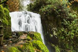
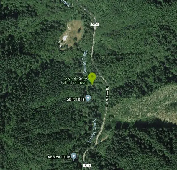
Sweet Creek Falls
Mapleton, Oregon
| Address: | 85520 Sweet Creek Rd, Mapleton, OR 97453, USA |
| GPS: |
43°57'28.8"N 123°54'7.8"W Maps | Directions |
| State: | Oregon |
| Trails/Routes: | 1.9 mi |
Hike
Superbly family friendly, this collection of small waterfalls enhances a shady hiking trail with fun bridges and metal walkways skirting the creek. Delightful year-round!Courtesy of eugenecascadescoast.org
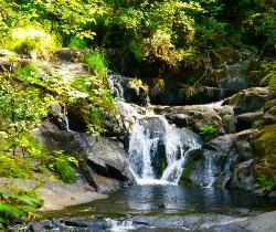
In this Coast Range valley, the Sweet Creek Falls Trail follows the scenic cascading waters of Sweet Creek. Hikers will encounter 11 waterfalls in all, each framed by mossy rocks and ferns and under a canopy of Douglas-fir, Alder and Big leaf maple. There are no bridge crossings of Sweet Creek. This trail consists of four segments. The Homestead Trailhead to Sweet Creek Falls is 1.1 miles. The Sweet Creek Falls Trailhead to Sweet Creek Falls is 0.4 mile. Sweet Creek Falls to the Wagon Road Trailhead is 0.8 mile. Wagon Road Trailhead to Beaver Creek Falls is 0.6 mile. Beaver Creek Falls is a 0.1 mile from the Beaver Creek Trailhead.Courtesy of fs.usda.gov
In the spring, the creek gushes powerfully with water, particularly after a rainy winter. Visit later in the summer, and you’ll get to climb down to the creek bed and hop along the rocks, searching for salamanders and crayfish.Courtesy of modernhiker.com
Google has walked and, much like street view has given us this interactive trail view.
More Information
Be courteous, informed, and prepared. Read trailhead guidelines, stay on the trail, and don't feed the wildlife.
Read More- Plan Ahead and Prepare
- Travel & camp on durable surfaces
- Dispose of waste properly
- Leave what you find
- Minimize campfire impacts
- Respect wildlife
- Be considerate of other visitors
Directions
From Mapleton, Oregon
- Head southeast on OR-36 W toward OR-126 E (30 ft)
- Turn left onto OR-126 E/State Hwy 126 E (0.2 mi)
- Turn right onto S Bank Mapleton West Rd/Sweet Creek RdContinue to follow Sweet Creek RdDestination will be on the right(10.2 mi)
 Upper Sweet Creek Waterfalls Oregon courtesy of Bonnie Moreland↗

 Along Sweet Creek Trail 2 courtesy of Rick Obst↗
 Sweet Creek Falls Trail Bridge courtesy of Rick Obst↗
 Sweet Creek Waterfalls Oregon courtesy of Bonnie Moreland↗
 Along Sweet Creek Trail courtesy of Rick Obst↗
 Along Sweet Creek Trail 3 courtesy of Rick Obst↗

Trails
Distance ?
1.9 miles Round TripElevation Gain ?
-311 feetReal Ascent ?
188 feetReal Descent ?
499 feetAvg Grade (-4°)
-6%Grade (-52° to 29°)
-129% to 55%Elevation differences are scaled for emphasis. While the numbers are accurate, the cut-away shown here is not to scale.
Other Hiking Trails Nearby
Beaver Creek Falls
Mapleton, Oregon
1.2 miles SEThe Beaver Falls Trail is one of these rare spots for an outing in Columbia County. On the way, you can also visit Upper Beaver Falls, not spectacular, but a very pretty roadside attraction. As you...
Hike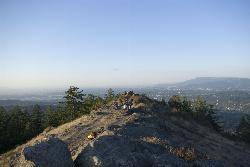
Spencer Butte
Eugene, Oregon
40.1 miles EIn need of a nearby hiking fix? Spencer Butte is the perfect place to get away from the city of Eugene and into the forest. Spencer Butte is a prominent landmark in Lane County, Oregon. It is...
Hike
Mount Pisgah
Eugene, Oregon
45.9 miles EMount Pisgah is a summit in Willamette Valley. It is a popular place for hiking, walking, and trail running because of how close it is to the city of Eugene and Springfield. The non-profit...
Hike


