Refine Search
- hike 8
- swim 2
- kayak 2
- horseback 2
- camp 2
- backpack 2
- sled 1
- canoe 1
- mountain bike 1
- cross-country ski 1
- snowshoe 1
- cave 1

Fall Creek Falls
Swan Valley, Idaho
2.1 miles SW of Swan Valley, IdahoFalls Campground is located next to the Snake River near beautiful Swan Valley, only 45 miles east of Idaho Falls, Idaho. Mixed growth cottonwood trees provide partial shade, and grassy meadows with summer wildflowers dot the area. Wildlife is plentiful in the river bottom; eagles, osprey, moose, and deer are frequently spotted. Fall Creek Falls is about 1/4 mile from the campground. The Snake River offers excellent trout fishing, canoeing, rafting, and kayaking. Spring Creek and Conant Boat Ramps, open to the public, are nearby. Palisades Reservoir is less than 20 miles from Falls Campground, with great boating, waterskiing, canoeing, fishing, and swimming.
Glacier Point
Yosemite National Park
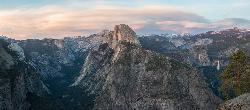
9.6 miles S of Yosemite National ParkLocated in Yosemite National Park, Glacier Point gives a birds-eye-view of the park you can't find anywhere else. It can be accessed by both hiking and driving through the park, though the roads may be closed until early to late May due to snow. Glacier Point towers over Yosemite Valley, sitting at 7,214 ft compared to the 4,000 ft valley floor.
From Glacier Point visitors are able to see the famous Half Dome, Vernal Falls, Nevada Falls, Yosemite Falls, El Capitan, and the Yosemite High Country. Each season offers a different view and feel for visitors. Come in the winter and you will see a snow covered Half Dome and High Country. Spring comes with the promise of new green leaves and roaring, snowmelt fed waterfalls. The summer still offers plenty of views, though a lot of tourists will be visiting. Fall brings a change of leaves throughout the park, and so it provides a beautiful contrast to the granite cliffs all around.
The trails to get to Glacier Point are the Four Mile Trail and the Panoramic Trail. The Four Mile Trail starts at the valley floor and like the name says, it is about 4.7 miles one way. Hiking up to Glacier Point has a significant level of elevation gain (Valley Floor is 4,000 ft and Glacier Point is 7,214 ft). The trail offers views of the Yosemite Valley that belong in a postcard. Those who hike to the top can enjoy an ice cream at the general store, while taking in the views. On the way down, hikers will see Yosemite Falls constantly in front of them, while the other sights of the valley floor come into view as the trail descends.
The Panoramic Trail is an alternative for going down from Glacier Point. Many hikers alternate between taking the Four Mile Trail up and the Panormaic Trail down (or vice versa). While the sights of the Four Mile Trail include many of the valley floor sights, the Panoramic Trail offers views of Illilouette, Nevada, and Vernal Falls. The trail ends at a different point than the Four Mile Trail, but hikers can take one of the free shuttles throughout the park.
Jenny Lake Trail
Jackson Hole, Wyoming
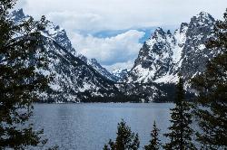
19.7 miles N of Jackson Hole, WyomingOne of the most popular trails to visit in Grand Teton is the Jenny Lake Trail. The Jenny Lake Trail, located near Moose, Wyoming, is an easy trail that loops around the lake. Along with the sheer beauty of Jenny Lake and surrounding mountains, some of the main attractions on this hike are Hidden Falls and Inspiration Point.
The trail underwent significant changes in 2018 after a fissure opened up and rock slides became an issue. The temporary changes made at that time, including trail reroutes and closures, have been undone and the lower trail is now open again taking onlookers all the way to Hidden Falls once again. The trail has been well built including hundreds of nicely placed stone stairs that keep the trail solid and provide great footing where you need it most.
Wildlife is common on the trails, including plenty of chipmunks, marmots, moose, deer, elk, and even an occasional bear. The best spot to see a moose or bear is often the overlook down to the Moose Pond Trail. You'll see a sign for the trail off to the left just a little ways before you get to the overlook. Even if you don't see any wildlife there though, the view of the ponds and Teewinot rising above is worth taking a break for. Other than this little jaunt over to the overlook and the hike up to Hidden Falls and Inspiration Point, the trail follows along the river for most of the way making any break you take a picturesque scene to enjoy.
The sunrise and sunset at Jenny Lake are incredible with radiant colors and exciting reflections off the water. Take a dip in Jenny Lake to cool off during summer months but remember that this is pretty fresh snow runoff so it may be colder than you think. For a little warmer swim, check out String Lake just to the North.
Between the soaring Tetons above, the falls above the trail, the raging river below the trail, and the expansive view of the lake and valley, there are plenty of great views to take in whether you see any wildlife or not.
Egin Lakes
Saint Anthony, Idaho
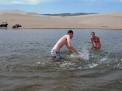
8.9 miles W of Saint Anthony, IdahoEgin Lakes is one of the favorite gateways to the St. Anthony Sand Dunes. The lakes themselves are unusually shallow and where you'll actually find a lake depends greatly on what time of the summer you go. The earlier in the year, the larger the lake. If you do find a lake, you'll find plenty of shallow areas for water games. The 2-3 feet deep areas are great for tackle football, ultimate frisbee, volleyball, or any other running game you want to take to the water. If you come early in the summer you'll find the lake extended pretty far east into the sandiest parts. It's the closest you'll find to a real beach in Southeast Idaho.
There is a $5 per vehicle access fee which gets you into a great parking lot, parts store, showers. The Egin Lakes Campground also offers a potable water system, RV dump station and 48 improved camp units, including electrical service. If you do ride ATVs at the dunes, be sure to take all proper precautions, including a flag for visibility.
Cress Creek Nature Trail
Rexburg, Idaho
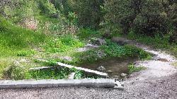
11.9 miles S of Rexburg, IdahoMeandering along the scenic South Fork of the Snake River, the beautiful 1¼ mile Cress Creek Nature Trail will lead you on a journey through sagebrush-grass communities, over juniper covered slopes, and along a lush perennial creek. Cress Creek derives its name from the watercress plant, a favorite food of the moose that live in this area. With clear skies, prepare for an expansive view of the Snake River, volcanoes and farmland. The site offers ample parking, restrooms and trail accessibility, which attract a wide spectrum of trail users to the area. You will become familiar with life in the Cress Creek area as it is now and as it was long ago. If you hike quietly you may see deer, rabbits, small lizards, or possibly an eagle or a moose. The nature trail is self-guided with many beautiful interpretive signs posted along the way to assist you. The first half-mile of the trail is accessible by wheelchair.
On the northeastern corner of the trail, there's an overlook trail. Parts of it are pretty nice like the rest of the loop but some is barely recognizable as a trail. Parts of the trail are steep and parts of it go over some pretty loose rock. It goes for about a ½ mile all the way to the top of the hill. Just below the rim, there are several really cool caves. From the top, you can see from Rexburg to Idaho Falls.
Herbert Idaho Ghost Town
Ririe, Idaho
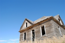
7.8 miles NE of Ririe, IdahoHerbert is a small ghost town that was operated until the 40s, but with the invention of the automobile, it was much more convenient to live in Rexburg or Rigby than in Herbert. At one point, it's been said that as many as 150 people lived here, mostly farmers or those who worked in the mines. The old house was tragically burned down by vandals in or around 2017.
Big Elk Creek
Irwin, Idaho
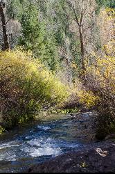
11.0 miles SE of Irwin, IdahoBig Elk Creak Campground is a very versitile campground with plenty of activities to keep busy. Campgrounds are available, with three group sites that include picnic tables and campfire rings. There is also a site with a covered picnic area available to reserve. Sites are reserved on a first come first serve basis.
Activities include fishing, hiking, horseback riding, kayaking, and more. On the drive into the camp you pass a small lake that is perfect for a more secluded lake experience if you don't want to go out onto Lake Palisade. About five minutes before reaching the campgrounds you will see the boat launch for the small dammed lake outside of the main Palisade Resevoir. From the campgrounds, you can float or kayak down the river to reach the lake. There is plenty of fishing in this small lake, however this lake DOES NOT provide access to the main Palisade Reservoir.
Towards the back end of the campground is the trailhead for the Big Elk Creek Trail. Following this trail will take you up into the mountains of the Caribou-Targhee National Forest, and over into Wyoming. It is perfect for backpacking as well as horseback riding along the trail. In the fall the Aspen trees are changing colors and the Douglas-Fir add some nice contrast in the mountains. The trail is a designated Leave No Trace zone, so please pack out all garabage and anything else you brought with you. The fall is a beautiful time to go, just remember to bring layers because the nights and early mornings get chilly.
Plenty of wildlife to see from mountain goats to squirrels, so just exercise caution while out there. There are bears in the area, so be sure to grab some bear spray and remember to lock up food in bear safes or practice different hanging methods so your food doesn't go missing.
Fees for use (as of 4/28/17)
$12/Night single sites
$24/Night double sites
Group sites are $50/night up to 35 people, $1/person thereafter
$6/night extra vehicle, $6/Day for Day Use Fee
Harriman State Park
Island Park, Idaho
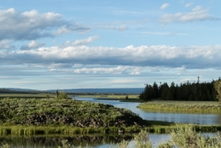
8.3 miles SW of Island Park, IdahoHarriman State Park is found 38 miles from Yellowstone along Henry's Fork. This 11,000-acre wildlife refuge is open year round for most activities. In addition to having beautiful scenery and wildlife, the area also has several houses that were built when the park was a privately owned ranch. The area is home to one of the best fly-fishing streams in the country, an eight mile portion of Henry's Fork river. There are many activities here including horseback riding, hiking, tours of the ranch, and fly-fishing.
During the summer, the trails through Harriman are a great place to hike and explore. There are plenty of wildflowers growing and the lakes and rivers flow nicely. Visitors will be able to see plenty of small wildlife, including swans on Silver lake, and there might even be a chance to see a moose or a bear. Part of the park crosses into the Caribou-Targhee National Forest. Along the river, there are beautiful views of the Tetons and the Yellowstone Plateau.
In the winter, the park is home to more than 24 miles of Nordic ski trails. The trails all vary in level of difficulty and distance. Most of the trails will go around Silver Lake and loop back towards the ranch houses. Other winter activites include fat biking and snowshoeing. The ranch houses are great in the winter because several have large fireplaces to warm up by.
The ranch houses can be rented out by visitors and have different accommodations for each house. Some of the houses include large gathering areas great for large groups of people. During different seasonns of the year the park offers events for the general public including star gazing and music camps.
This is an Idaho State Park and there are day use fees. Passes have reciprocity with Mesa Falls State Park which is only about 20 minutes away.
Mist Trail
Yosemite National Park
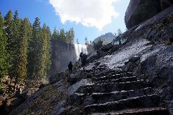
9.2 miles S of Yosemite National ParkThe mist trail is a small breakoff from the John Muir Trail through Yosemite National Park. It's called the mist trail because of the heavy amount of mist that hikers walk through as Vernal and Nevada Falls crash hundreds of feet below. The hike is short as for horizontal distance traveled but the incline will give you a run for your money. You'll ascend 639 stone stairs to reach the top of Vernal Falls. There's a waterfall in between the two that is a sight all it's own but is often forgotten because of the behemoths on either side. The hike between the falls is a nice break as it is fairly flat relative to the rest of the trail. Once you get to the base of Nevada Falls, you'll have to take switchbacks up the giant cliffs to the top.
These waterfalls are usually the last to dry up around Yellowstone Village. Whether you just love waterfalls or you want a closer view of Halfdome, Whitecap, or Mt. Broderick, the Mist Trail definitely offers world class views. There are bathroom facilities just above Vernal Falls and water just before you start to ascend the stairs. There's another trail that is less steep but that skips Vernal Falls.
Distances (one-way):
| Hike | Distance | Elevation Gain |
|---|---|---|
| Vernal Fall Bridge | 0.8 miles | 400 ft |
| Top of Vernal Falls | 1.5 miles | 1100 ft |
| Top of Nevada Falls | 3.4 miles | 2230 ft |


