


174.8K Little River Canyon Swimming Holes by freearenas
first prev 1 next lastEmerald-green swimming holes in the Little River Canyon National Preserve near Fort Payne, Alabama, one of the deepest gorges east of the Mississippi, from the iconic 45-foot Little River Falls to the famous Little Falls (Martha's Falls / Hippie Hole).
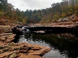
Martha's Falls
Fort Payne, Alabama
6.9 miles SE of Fort Payne, AlabamaMartha's Falls, also called Little Falls and known to locals as the "Hippie Hole," is the most beloved swimming hole in the Little River Canyon National Preserve near Fort Payne, Alabama, and one of the most photographed spots in the state. It is not a tall waterfall but a wide one: the Little River slides over a broad, low shelf of sandstone into a generous pool whose water glows an almost unreal emerald green. That color is the tell of a sky-fed river running clear over pale stone, and the pool has been carved into the canyon floor over thousands of years, deep enough in the middle for real swimming and shallow at the edges for kids and waders.
The low ledge is made for sliding and small jumps, and the rock walls around the pool give bolder swimmers a range of higher launch points, though how high is safe changes with the water level. On a hot Alabama afternoon it fills with families, teenagers and out-of-towners; international "best swimming holes" lists have found it in recent years, and summer weekends can be genuinely busy, so an early start or a weekday visit buys you more of the canyon to yourself.
Reaching the water is the price of admission. Parking is a lot off Highway 35 near County Road 861, and the trail down is close to a mile. It begins gently, an easy five-minute walk along a gravel service road, then turns left onto a rooted footpath and drops steeply over the last hundred yards of rocky ground to the canyon floor. The park has added stone steps on the steepest section, which helps, but the trail is still rated moderate-to-strenuous and can be slick when wet, and the climb back out in the heat is the hard part.
Facilities are deliberately minimal: there are no picnic tables and no trash service down at the water, dogs are welcome on a six-foot leash, and alcohol is not permitted anywhere in the preserve. The biggest thing to respect is the river itself. Levels and current rise fast after rain, the smooth rock gets slippery, and what looks like a calm pool can develop real pull, so it pays to look before you leap and to check conditions after a storm.
Late spring through early fall is the swimming season, midsummer the warmest and most crowded, the shoulder weeks quieter and cooler. Martha's Falls sits partway down the gorge from Little River Falls at the head of the canyon, so it pairs naturally with a stop at the falls overlook and a drive along the 22-mile Little River Canyon Rim Parkway. For clear green water in a rugged sandstone canyon, earned by a short, sweaty hike, it is hard to beat in the Southeast.
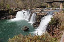
Little River Falls
Fort Payne, Alabama
6.5 miles SE of Fort Payne, AlabamaLittle River Falls is the dramatic centerpiece at the head of the Little River Canyon National Preserve near Fort Payne, Alabama, on the line between DeKalb and Cherokee counties. Here the Little River, one of the very few rivers in the country that flows almost its entire length along the top of a mountain, reaches the edge of Lookout Mountain and plunges roughly 45 feet over a sandstone lip before beginning its rush into the deep gorge below. It is very likely the most accessible large waterfall in Alabama: a paved overlook and a short boardwalk deliver you right to the brink with almost no walking, which makes it the busiest and most photographed stop in the preserve.
The falls are at their most thunderous in late winter and spring, when rain and snowmelt swell the river and the whole ledge turns into a curtain of whitewater; by midsummer the flow drops and the character shifts from spectacle to swimming hole. Above and below the lip the river spreads across broad slabs of slickrock and gathers into pools that draw waders, sunbathers and swimmers on hot days. The rock is inviting but genuinely slick, and the water right at the falls is powerful, so the Park Service asks people to stay well back from the edge; most swimming happens in the calmer pools away from the drop, and this is a place where underestimating the current has gotten people into serious trouble, especially after rain.
From the falls, the 22-mile Little River Canyon Rim Parkway runs south along the west rim past a string of overlooks into one of the deepest canyons east of the Mississippi, a gorge of pale sandstone, hardwood forest and hidden pools. The preserve anchors a cluster of famous Lookout Mountain waterfalls: Grace's High Falls, among the tallest in Alabama, drops seasonally from a side canyon a few miles down the parkway, and DeSoto Falls sits a short drive north, so a single day can easily string together several of the state's best.
Practical notes are simple. The main overlook and boardwalk are open year-round and free, with parking right off Highway 35 just east of the bridge over the Little River. There is a picnic area nearby, and the Little River Canyon Center on Highway 35 makes a good first stop for current conditions and trail information. The best light for photos is morning, and the best show is any time after a good rain. Whether you come to stand at the brink of a 45-foot waterfall with no effort at all or to wade the pools on a summer afternoon, Little River Falls is the easy, iconic introduction to the canyon before the wilder swimming holes downstream.


